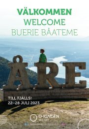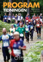
O-Ringen Magazine, nr 1 2024
The worlds biggest orienteering adventure. Oskarshamn, Smålandskusten, July 21st to 27 th 2024.
The worlds biggest orienteering adventure. Oskarshamn, Smålandskusten, July 21st to 27 th 2024.

You also want an ePaper? Increase the reach of your titles
YUMPU automatically turns print PDFs into web optimized ePapers that Google loves.
When there is<br />
so much rock<br />
detail, try to<br />
see through it<br />
and focus on the<br />
contours<br />
Lena – what would you say are the three<br />
most important orienteering skills?<br />
1. Taking a compass bearing out from the<br />
control to your first collecting feature<br />
2. Keep reading the map as you go<br />
3. Using the contour features<br />
Jakob – what would you say are the three<br />
most important orienteering skills?<br />
1. Choosing clear collecting features that<br />
you’re confident of being able to see<br />
2. Checking your compass frequently<br />
between these features<br />
3. The discipline to stop when you’re unsure<br />
and make sure you relocate before you<br />
continue. Parallel mistakes are easy to make!<br />
Training and preparation<br />
For those who don’t run WOC or the<br />
Swedish Championships, O-<strong>Ringen</strong> is often<br />
high on every orienteer’s list of events they<br />
would like to run well at. It doesn’t need to<br />
be about the podium – for many people,<br />
success means five stable races that you’re<br />
happy with afterwards. For some people, the<br />
challenge is physical and a case of whether<br />
your body will get round the five days and<br />
for others it’s mainly the technical orienteering<br />
that’s a challenge. Regardless of what<br />
your goals are, it’s important to arrive well<br />
prepared for the competitions. The better<br />
your training and preparation, the better<br />
your O-<strong>Ringen</strong> week.<br />
What would you recommend as extra<br />
training to prepare for O-<strong>Ringen</strong> <strong>2024</strong>?<br />
– Training to read the contours, to follow<br />
the hill shapes and even run up on top of<br />
the hills. When there is so much rock detail,<br />
try to look through it and focus on the contours,<br />
says Lena.<br />
– You could train on areas with lots of<br />
contour detail and small hill shapes, for<br />
example. If you don’t have these near you,<br />
2<br />
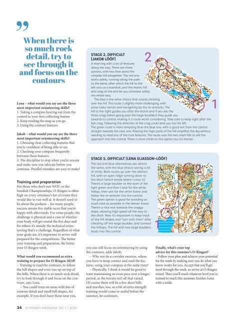
STAGE 2, DIFFICULT<br />
(JAKOB LÖÖF)<br />
A short leg with a lot of features<br />
along the way. There are three<br />
options, with two that avoid the<br />
complex hill altogether. The red one<br />
starts safely, running along the path<br />
to the bend, after which the hill to the<br />
left acts as a handrail, and the marsh, hill<br />
and crag at the end let you orienteer safely<br />
the whole way.<br />
The blue is the other choice that avoids climbing<br />
over the hill. This route is slightly more challenging, with<br />
some rocky terrain and navigating by the re-entrants. The<br />
hill to the right guides you after the marsh and if you see the<br />
three crags (when going past the large boulders) they guide you<br />
towards to control, making it a route worth considering. Take care to keep right after the<br />
last crag, following the direction of the crag could lead you too far left.<br />
The green route is more tempting than the blue one, with a good exit from the control<br />
straight towards the next one. Passing the high point of the hill simplifies the leg without<br />
needing to read any of the rock features. The route uses the two small hills to aid the<br />
approach into the control. There is more climb on this option but it’s shorter.<br />
STAGE 5, DIFFICULT (LENA ELIASSON-LÖÖF)<br />
The red and blue alternatives are almost<br />
the same, with the blue choice saving a bit<br />
of climb. Both routes go over the distinct<br />
hill, with an open ridge running down to<br />
the ditch (which bends where I cross it).<br />
There’s a large boulder at the start of the<br />
light green and then I look for the white<br />
hilltop, then aim for the white forest and<br />
follow the re-entrant into the control.<br />
The green option is good for avoiding as<br />
much rock as possible in the denser forest.<br />
There’s a nice exit towards the craggy<br />
slope, allowing high speed all the way to<br />
the ditch. Now it’s important to keep track<br />
of the hill shapes and “turn with them” after<br />
checking off the large boulder, and connect<br />
the hilltops. The hill with two large boulders<br />
leads into the control.<br />
you can still focus on orienteering by using<br />
the contours, adds Jakob.<br />
– Why not do a corridor exercise, where<br />
you have to keep contact and read the features,<br />
using your compass at the same time?<br />
– Physically, I think it would be good to<br />
train maintaining an even pace over a longer<br />
period, as the terrain isn’t all that varied.<br />
Of course there will be a few short hills<br />
and marshes, too, so a bit of extra strength<br />
training would come in useful before the<br />
summer, he continues.<br />
1<br />
2<br />
1<br />
Finally, what’s your top<br />
advice for this summer’s O-<strong>Ringen</strong>?<br />
– Follow your plan and achieve your potential<br />
for the week by making sure you do what you<br />
know works for you. Accept that you’ll get<br />
tired through the week, so arrive at O-<strong>Ringen</strong><br />
rested. Then you’ll reach whatever level you’ve<br />
trained to reach this summer, finishes Lena<br />
with a smile.<br />
STAGE 5, MODERATE (LENA ELIASSON-LÖÖF)<br />
The green option uses mostly paths and areas where it’s easier<br />
to run. However, it’s important to keep track of distance and<br />
features, since the path is small. It’s good to have a clear point to<br />
leave the path, in this case the open area. From there, a careful<br />
bearing is needed towards the field, then the open hill, then<br />
you have to find the white forest with minimal running in denser<br />
areas. Use the distinct hilltop as your attack point.<br />
The red route is for those who feel confident in their contour<br />
reading. It’s important to take a good bearing and check off the<br />
larger collecting features like the hill formation on the other side<br />
of the path, the greener, marshier forest and the smaller hills<br />
in the more open forest. There, it’s important to notice the ride<br />
crossing the stream, taking you up onto the hill. Now it’s sticking<br />
to your bearing, then picking up the ditch bend going into the<br />
denser area. The large boulders where the control is should come<br />
into view when the forest opens up again.<br />
The blue option involves less map-reading in the middle of the<br />
leg, with path running until the large, distinctive boulder where<br />
you turn off. The way to the track requires a clear direction to<br />
optimise your lines near the corner of the open and the ditch<br />
crossing. Leave the track at the bend and the distinct hilltops.<br />
Look for the large boulders and from there, follow a careful<br />
bearing to the edge of the green forest, down to the marshy area<br />
with the ditch bend and then out into the open terrain to avoid<br />
approaching the control through dense forest.<br />
1<br />
2<br />
34 O-RINGEN MAGAZINE NO. 1 • <strong>2024</strong> O-RINGEN MAGAZINE NO. 1 • <strong>2024</strong> 35