

(CRAM) For Wetlands User's Manual Version 5.0.2
(CRAM) For Wetlands User's Manual Version 5.0.2
(CRAM) For Wetlands User's Manual Version 5.0.2

You also want an ePaper? Increase the reach of your titles
YUMPU automatically turns print PDFs into web optimized ePapers that Google loves.
California Rapid Assessment Method for <strong>Wetlands</strong> v. <strong>5.0.2</strong> – Chapter 3<br />
The best achievable condition of a project might be unavoidably constrained by adjacent or<br />
nearby land uses. In these situations, the expected or target level of performance of a project<br />
might be adjusted for the land use constraints. In other words, although a project is assessed<br />
relative to the best achievable conditions for its wetland type throughout the State, what is<br />
expected or deemed acceptable for any particular project might reflect its land use setting. <strong>For</strong><br />
example, stream restoration projects in urban landscapes need not be held to the same standards<br />
of high performance as projects in rural or non-developed landscapes. As <strong>CRAM</strong> scores<br />
accumulate throughout the State, their relationship to land use setting can be analyzed to guide<br />
local adjustments in project performance criteria that are based on <strong>CRAM</strong>.<br />
3.6 Step 6: Conduct Initial Office Assessment of Condition Metrics and Stressors<br />
<strong>For</strong> each <strong>CRAM</strong> assessment, there is initial office work to acquire the site imagery, plan logistics<br />
for the site visit, and to assemble information about the management of the site and its possible<br />
stressors. Preliminary scores can be developed for some metrics, based on existing<br />
documentation (e.g., aerial photography, reports, etc.), prior to conducting any fieldwork. Such<br />
preliminary scoring is not necessary, however, and any preliminary scores must be verified<br />
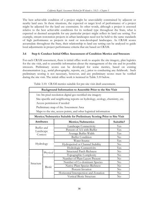
during the site visit. The initial office work is itemized in Table 3.10 below.<br />
Table 3.10: <strong>CRAM</strong> metrics suitable for pre-site visit draft assessment.<br />
Background Information to Assemble Prior to the Site Visit<br />
1m-3m pixel resolution digital geo-rectified site imagery<br />
Site-specific and neighboring reports on hydrology, ecology, chemistry, etc.<br />
Access permission if needed<br />
Preliminary map of the Assessment Area<br />
Maps to the site, access points, and other logistical information<br />
Metrics/Submetrics Suitable for Preliminary Scoring Prior to Site Visit<br />
Attributes Metrics/Submetrics Suitable?<br />
Buffer and<br />
Landscape<br />
Context<br />
Hydrology<br />
Structure<br />
Physical<br />
Biotic<br />
Landscape Connectivity Yes<br />
Percent of AA with Buffer Yes<br />
Average Buffer Width Yes<br />
Buffer Condition No<br />
Water Source Yes<br />
Hydroperiod or Channel Stability No<br />
Hydrologic Connectivity Yes<br />
Structural Patch Richness No<br />
Topographic Complexity No<br />
Number of Plant Layers Present No<br />
Number of Co-dominant Species No<br />
Native Plant Species Richness No<br />
Percent Invasion No<br />
Horizontal Interspersion and Zonation No<br />
Vertical Biotic Structure No<br />
36


