

(CRAM) For Wetlands User's Manual Version 5.0.2
(CRAM) For Wetlands User's Manual Version 5.0.2
(CRAM) For Wetlands User's Manual Version 5.0.2

You also want an ePaper? Increase the reach of your titles
YUMPU automatically turns print PDFs into web optimized ePapers that Google loves.
California Rapid Assessment Method for <strong>Wetlands</strong> v. <strong>5.0.2</strong> – Chapter 4<br />
4.4.2 Horizontal Interspersion and Zonation<br />
A. Definition: Horizontal biotic structure refers to the variety and interspersion of plant<br />
“zones.” Plant zones are plant monocultures or obvious multi-species associations that are<br />
arrayed along gradients of elevation, moisture, or other environmental factors that seem to affect<br />
the plant community organization in plan view. Interspersion is essentially a measure of the<br />
number of distinct plant zones and the amount of edge between them.<br />
B. Rationale: The existence of multiple horizontal plant zones indicates a well-developed plant<br />
community and predictable sedimentary and bio-chemical processes. The amount of<br />
interspersion among these plant zones is indicative of the spatial heterogeneity of these<br />
processes. Richer native communities of plants and animals tend to be associated with greater<br />
zonation and more interspersion of the plant zones.<br />
C. Seasonality: This metric is not sensitive to seasonality.<br />
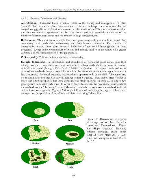
D. Field Indicators: The distribution and abundance of horizontal plant zones, plus their<br />
interspersion, are combined into a single indicator. <strong>For</strong> large wetlands, the prominent zonation<br />
is evident in aerial photographs of scale 1:24,000 or smaller. <strong>For</strong> vernal pools and other<br />
depressional wetlands that are essentially round in plan form, the plant zones might be more or<br />
less concentric. <strong>For</strong> small wetlands, the zonation is apparent only in the field. The zones may<br />
be discontinuous and they can vary in number within a wetland. Plant zones often consist of<br />
more than one plant species, but some zones may be mono-specific. In some cases, one or two<br />
plant species dominates each zone. In order to score this metric, the practitioner must evaluate<br />
the wetland from a "plan view," i.e., as if the observer was hovering above the wetland in the air<br />
and looking down upon it. Figure 4.7 through 4.10 can aid evaluating the degree of horizontal<br />
interspersion (adapted from Mack 2001), which is rated using Table 4.19a-c.<br />
Low Low<br />
Medium<br />
Medium<br />
High High<br />
83<br />
Figure 4.7: Diagram of the degrees<br />
of interspersion of plant zones for<br />
Lacustrine, Depressional, Playas,<br />
and Slope wetlands. Hatching<br />
patterns represent plant zones<br />
(adapted from Mack 2001). Each<br />
zone must comprise at least 5% of<br />
the AA.


