

(CRAM) For Wetlands User's Manual Version 5.0.2
(CRAM) For Wetlands User's Manual Version 5.0.2
(CRAM) For Wetlands User's Manual Version 5.0.2

Create successful ePaper yourself
Turn your PDF publications into a flip-book with our unique Google optimized e-Paper software.
California Rapid Assessment Method for <strong>Wetlands</strong> v. <strong>5.0.2</strong> – Chapter 4<br />
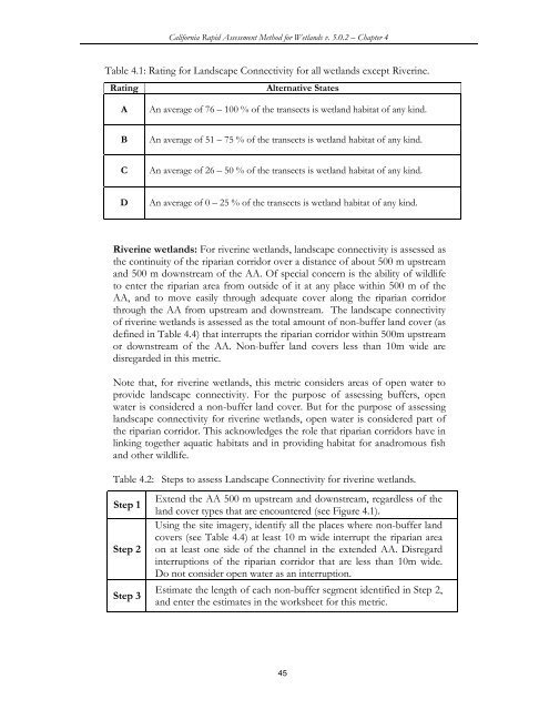
Table 4.1: Rating for Landscape Connectivity for all wetlands except Riverine.<br />
Rating Alternative States<br />
A An average of 76 – 100 % of the transects is wetland habitat of any kind.<br />
B An average of 51 – 75 % of the transects is wetland habitat of any kind.<br />
C An average of 26 – 50 % of the transects is wetland habitat of any kind.<br />
D An average of 0 – 25 % of the transects is wetland habitat of any kind.<br />
Riverine wetlands: <strong>For</strong> riverine wetlands, landscape connectivity is assessed as<br />
the continuity of the riparian corridor over a distance of about 500 m upstream<br />
and 500 m downstream of the AA. Of special concern is the ability of wildlife<br />
to enter the riparian area from outside of it at any place within 500 m of the<br />
AA, and to move easily through adequate cover along the riparian corridor<br />
through the AA from upstream and downstream. The landscape connectivity<br />
of riverine wetlands is assessed as the total amount of non-buffer land cover (as<br />
defined in Table 4.4) that interrupts the riparian corridor within 500m upstream<br />
or downstream of the AA. Non-buffer land covers less than 10m wide are<br />
disregarded in this metric.<br />
Note that, for riverine wetlands, this metric considers areas of open water to<br />
provide landscape connectivity. <strong>For</strong> the purpose of assessing buffers, open<br />
water is considered a non-buffer land cover. But for the purpose of assessing<br />
landscape connectivity for riverine wetlands, open water is considered part of<br />
the riparian corridor. This acknowledges the role that riparian corridors have in<br />
linking together aquatic habitats and in providing habitat for anadromous fish<br />
and other wildlife.<br />
Table 4.2: Steps to assess Landscape Connectivity for riverine wetlands.<br />
Step 1<br />
Step 2<br />
Step 3<br />
Extend the AA 500 m upstream and downstream, regardless of the<br />
land cover types that are encountered (see Figure 4.1).<br />
Using the site imagery, identify all the places where non-buffer land<br />
covers (see Table 4.4) at least 10 m wide interrupt the riparian area<br />
on at least one side of the channel in the extended AA. Disregard<br />
interruptions of the riparian corridor that are less than 10m wide.<br />
Do not consider open water as an interruption.<br />
Estimate the length of each non-buffer segment identified in Step 2,<br />
and enter the estimates in the worksheet for this metric.<br />
45


