- Page 1 and 2: Compendio de Trabajos de Investigac
- Page 3 and 4: Al realizar las climatologías espa
- Page 5 and 6: Variación Mensual (Figura 4a, b) E
- Page 7 and 8: Variabilidad Espacio-Temporal de la
- Page 9 and 10: Variabilidad Espacio-Temporal de la
- Page 11 and 12: Variabilidad Espacio-Temporal de la
- Page 13 and 14: el rango de -0,5ºC y -1,0ºC y fre
- Page 15 and 16: Niñas Áreas Variabilidad Espacio-
- Page 17 and 18: afloramiento en la región), y se o
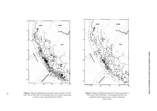
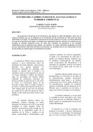
- Page 19 and 20: A. Cahuari Kanamori, 1979), han est
- Page 21 and 22: A. Cahuari A fin de analizar las ca
- Page 23: A. Cahuari 4. La distribución espa
- Page 27 and 28: Mo dinas.cm A. Cahuari Mo dinas.cm
- Page 29 and 30: Mo dinas.cm Mo dinas.cm Mo dinas.cm
- Page 31 and 32: A. Cahuari 2.82E+25 dinas.cm, y que
- Page 33 and 34: Compendio de Trabajos de Investigac
- Page 35 and 36: CLASIFICACIÓN DE LOS MICROTREMORES
- Page 37 and 38: predominantes superiores a 0.2 segu
- Page 39 and 40: debido a su bajo costo y simplicida
- Page 41 and 42: un arrays, hasta el cálculo del mo
- Page 43 and 44: para estudios de microzonificación
- Page 45 and 46: Omori, F. On microtremors. Boletín
- Page 47 and 48: L. Arredondo 58 En la Figura 1 se m
- Page 49 and 50: L. Arredondo estarían asociados pr
- Page 51 and 52: L. Arredondo Figura 4. Perfiles per
- Page 53 and 54: L. Arredondo (NEIC), la magnitud en
- Page 55 and 56: L. Arredondo De acuerdo a la Figura
- Page 57 and 58: L. Arredondo 58 En la Figura 1 se m
- Page 59 and 60: L. Arredondo estarían asociados pr
- Page 61 and 62: L. Arredondo Figura 4. Perfiles per
- Page 63 and 64: L. Arredondo (NEIC), la magnitud en
- Page 65 and 66: L. Arredondo De acuerdo a la Figura
- Page 67 and 68: F. Rosado sobre la aplicación de e
- Page 69 and 70: F. Rosado fuente sísmica y del cam
- Page 71 and 72: F. Rosado Método de Pujades (1987)
- Page 73 and 74: F. Rosado Modelo de flujo de energ
- Page 75 and 76:
F. Rosado - Regionalización de cod
- Page 77 and 78:
F. Rosado western Anatolia (Turkey)
- Page 79 and 80:
Compendio de Trabajos de Investigac
- Page 81 and 82:
u x ∂ϕ ∂ψ = − , ∂x ∂z s
- Page 83 and 84:
ξ ≈ 0. 8475 y η ≈ 0. 3933 y c
- Page 85 and 86:
teniendo en cuenta su desplazamient
- Page 87 and 88:
Compendio de Trabajos de Investigac
- Page 89 and 90:
parte de la Red Sísmica Nacional d
- Page 91 and 92:
frecuencias dos veces mayor que las
- Page 93 and 94:
acoplador movimiento del árbol a l
- Page 95 and 96:
Para lograr el filtrado de los regi
- Page 97 and 98:
locales son los dados por los cambi
- Page 99 and 100:
Compendio de Trabajos de Investigac
- Page 101 and 102:
Sismicidad Alta Toma en cuenta a lo
- Page 103 and 104:
I II Zonificación sísmica Prelimi
- Page 105 and 106:
Los departamentos de Amazonas, Apur
- Page 107 and 108:
MAPA DE LA ZONIFICACION DEL PERU Zo
- Page 109 and 110:
Compendio de Trabajos de Investigac
- Page 111 and 112:
Por lo tanto, “inestabilidad” e
- Page 113 and 114:
Adaptación conjugada simultánea d
- Page 115 and 116:
Tabla 1. Parámetros “S” medido
- Page 117 and 118:
Diseño de las redes de adaptación
- Page 119 and 120:
muestra en el punto “P” de la F
- Page 121 and 122:
Figura 13. Frecuencia central de am
- Page 123 and 124:
Worcester Polytechnic Institute. Pa
- Page 125 and 126:
J. Espinoza Fase1: Pre-Calentamient
- Page 127 and 128:
J. Espinoza pin RB3 estará configu
- Page 129 and 130:
J. Espinoza La Ec. diferencial que
- Page 131 and 132:
J. Espinoza Programa del microcontr
- Page 133 and 134:
J. Espinoza 136 INICIO CONFIGURACIO
- Page 135 and 136:
J. Espinoza La implementación de u
- Page 137 and 138:
F. Galindo Figura 1. Ecos de meteor
- Page 139 and 140:
F. Galindo Figura 4. El proceso de
- Page 141 and 142:
F. Galindo utiliza las característ
- Page 143 and 144:
F. Galindo Dyrud, L. M. Oppenheim,
- Page 145 and 146:
F. Galindo Figura 1. Ecos de meteor
- Page 147 and 148:
F. Galindo Figura 4. El proceso de
- Page 149 and 150:
F. Galindo utiliza las característ
- Page 151 and 152:
F. Galindo Dyrud, L. M. Oppenheim,
- Page 153 and 154:
R. Quispe PB : es la línea que se
- Page 155 and 156:
R. Quispe Software Usados para la R
- Page 157 and 158:
R. Quispe 152 DATOS NO FILTRADOS en
- Page 159 and 160:
R. Quispe 154 Tablas DATOS FILTRADO
- Page 161 and 162:
R. Quispe AGRADECIMIENTOS Hago lleg
- Page 163 and 164:
A. Quispe la imagen de la UNICA-IGP
- Page 165 and 166:
A. Quispe N ú m e r o I n t e r n
- Page 167 and 168:
A. Quispe SUNPOTS DATA 162 Tabla02.
- Page 169 and 170:
Compendio de Trabajos de Investigac
- Page 171 and 172:
ángulo de posición del extremo No
- Page 173 and 174:
Ejemplo: El día 27 de febrero del
- Page 175 and 176:
Dia Juliano P 2470000 2460000 24500
- Page 177 and 178:
Japón por el asesoramiento en la e
- Page 179 and 180:
A. Taco modelos de elevación digit
- Page 181 and 182:
A. Taco pendientes suaves y vicever
- Page 183 and 184:
A. Taco fotografías aéreas a esca
- Page 185 and 186:
A. Taco donde ; 182 , y La determin
- Page 187 and 188:
A. Taco elementos estructurales se
- Page 189 and 190:
A. Taco operador difuso OR (máximo
- Page 191 and 192:
A. Taco posibilidad de ser aplicada
- Page 193 and 194:
Compendio de Trabajos de Investigac
- Page 195 and 196:
Donde: Uso de los SIG en el anális
- Page 197 and 198:
C. Cereceda Modelo SINMAP El cálcu
- Page 199 and 200:
en las diferentes condiciones de pr
- Page 201 and 202:
Uso de los SIG en el análisis de s
- Page 203:
Lana, H.X., C.H. Zhou, L.J. Wang, H