THÃS EE - CESBIO - Université Toulouse III - Paul Sabatier
THÃS EE - CESBIO - Université Toulouse III - Paul Sabatier
THÃS EE - CESBIO - Université Toulouse III - Paul Sabatier
Create successful ePaper yourself
Turn your PDF publications into a flip-book with our unique Google optimized e-Paper software.
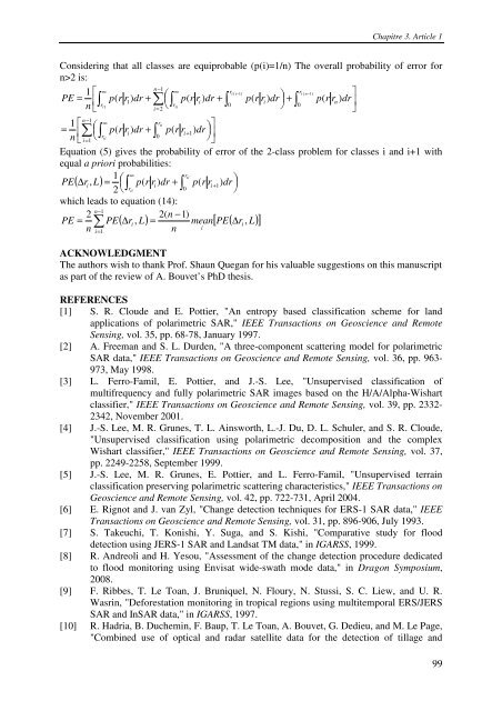
Chapitre 3. Article 1Considering that all classes are equiprobable (p(i)=1/n) The overall probability of error forn>2 is:⎡⎤=1 ∞n−1∞rt( i−1)rt( n−1PE ⎢ + ⎜⎛ +⎟⎞∫ p(r r1) dr ∑+⎥⎣⎝∫p(r r ) ∫ ( )0 ⎠ ∫)i( )r 1ridr p r r dr p r r0ndrn ttii=2⎦n−11 ⎡ ∞rti⎤= ⎢ ⎜⎛ +⎟⎞∑⎥⎣ ⎝∫p(r ri) dr ∫ p(r ri+ 1)drn rti0i=1⎠⎦Equation (5) gives the probability of error of the 2-class problem for classes i and i+1 withequal a priori probabilities:1 ∞rtiPE( ∆r) = ⎜⎛ +⎟⎞i,L⎝∫ p r ridr ∫ p r ri+ 1dr2( ) ( )rti0 ⎠which leads to equation (14):n2 1 2( n −1)PE = ∑ − PE( ∆ri , L) = mean[ PE( ∆ri, L)]nn i= 1iACKNOWLEDGMENTThe authors wish to thank Prof. Shaun Quegan for his valuable suggestions on this manuscriptas part of the review of A. Bouvet’s PhD thesis.REFERENCES[1] S. R. Cloude and E. Pottier, "An entropy based classification scheme for landapplications of polarimetric SAR," I<strong>EE</strong>E Transactions on Geoscience and RemoteSensing, vol. 35, pp. 68-78, January 1997.[2] A. Freeman and S. L. Durden, "A three-component scattering model for polarimetricSAR data," I<strong>EE</strong>E Transactions on Geoscience and Remote Sensing, vol. 36, pp. 963-973, May 1998.[3] L. Ferro-Famil, E. Pottier, and J.-S. Lee, "Unsupervised classification ofmultifrequency and fully polarimetric SAR images based on the H/A/Alpha-Wishartclassifier," I<strong>EE</strong>E Transactions on Geoscience and Remote Sensing, vol. 39, pp. 2332-2342, November 2001.[4] J.-S. Lee, M. R. Grunes, T. L. Ainsworth, L.-J. Du, D. L. Schuler, and S. R. Cloude,"Unsupervised classification using polarimetric decomposition and the complexWishart classifier," I<strong>EE</strong>E Transactions on Geoscience and Remote Sensing, vol. 37,pp. 2249-2258, September 1999.[5] J.-S. Lee, M. R. Grunes, E. Pottier, and L. Ferro-Famil, "Unsupervised terrainclassification preserving polarimetric scattering characteristics," I<strong>EE</strong>E Transactions onGeoscience and Remote Sensing, vol. 42, pp. 722-731, April 2004.[6] E. Rignot and J. van Zyl, "Change detection techniques for ERS-1 SAR data," I<strong>EE</strong>ETransactions on Geoscience and Remote Sensing, vol. 31, pp. 896-906, July 1993.[7] S. Takeuchi, T. Konishi, Y. Suga, and S. Kishi, "Comparative study for flooddetection using JERS-1 SAR and Landsat TM data," in IGARSS, 1999.[8] R. Andreoli and H. Yesou, "Assessment of the change detection procedure dedicatedto flood monitoring using Envisat wide-swath mode data," in Dragon Symposium,2008.[9] F. Ribbes, T. Le Toan, J. Bruniquel, N. Floury, N. Stussi, S. C. Liew, and U. R.Wasrin, "Deforestation monitoring in tropical regions using multitemporal ERS/JERSSAR and InSAR data," in IGARSS, 1997.[10] R. Hadria, B. Duchemin, F. Baup, T. Le Toan, A. Bouvet, G. Dedieu, and M. Le Page,"Combined use of optical and radar satellite data for the detection of tillage and99


