


Create successful ePaper yourself
Turn your PDF publications into a flip-book with our unique Google optimized e-Paper software.
GUEST PAPER<br />
This experimental study represent a<br />
proposal to integrate geographic datasets<br />
that are usually used in other application<br />
fields and for very different purpose.<br />
One of the target of this project is<br />
to suggest how is a possible way to best<br />
integrate ISTAT geographic dataset that<br />
rarely are used as land/cover data.<br />
There are a lot of benefits derived from<br />
the use of LANDSAT images; first of all<br />
they are free and then they cover, for<br />
the areas of overlapping scenes, large<br />
territorial portions every eight days. To<br />
use ISTAT data gives a great advantage<br />
overall in evaluation of ‘urban sprawl’<br />
phenomenon; in fact from ISTAT enumeration<br />
parcels layer can be extracted<br />
little urban agglomerations that are<br />
cancelled in medium scale cartography,<br />
and this fact generate an error in quantification<br />
of land cover/use classes.<br />
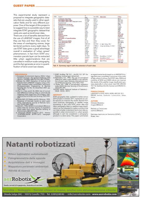
Tab. 4 - Summary report with the extension of each class.<br />
BIBLIOGRAFIA<br />
1. European Environment Agency (EEA): Urban<br />
Sprawl in Europe - the ignored challenge, EEA<br />
report n. 10/2006. ISBN 92-9167-887-2 (2006)<br />
2.Hanqiu Xu, 2007. Extraction of built-up land<br />
features from LANDSAT imagery using a thematic<br />
oriented index combination technique.<br />
Photogrammetric Engineering & Remote<br />
Sensing, Vol. 73, No. 12, December 2007, pp.<br />
1381–1391<br />
3. Zha, Y., J. Gao, and S. Ni, 2003. Use of normalized<br />
difference built-up index in automatically<br />
mapping urban areas from TM imagery, International<br />
Journal of Remote Sensing, 24(3):583–<br />
594<br />
4.Cibula, W.G., E.F. Zetka, and D.L. Rickman, 1992.<br />
Response of thematic bands to plant water<br />
stress, International Journal of Remote Sensing,<br />
13(10):1869–1880<br />
5.Gao, B.C., 1996. NDWI–A normalized difference<br />
water index for remote sensing of vegetation<br />
liquid water from space, Remote Sensing of<br />
Environment, 58(3):257–266<br />
6. Intergraph ERDAS Imagine® 2013 - Version<br />
13.00.0002.00598 ©1991-2013 Intergraph<br />
Corporation<br />
7. ESRI® ArcMap TM 10.1 – ArcGIS 10.1 SP1 for<br />
Desktop, License type: Advanced<br />
8. McFeeters, S.K., 1996. The use of normalized<br />
difference water index (NDWI) in the <strong>del</strong>ineation<br />
of open water features, International Journal<br />
of Remote Sensing, 17(7):1425–1432<br />
9. Huete, A.R., 1988. A soil-adjusted vegetation<br />
index (SAVI), Remote Sensing of Environment,<br />
25(3):295–309<br />
10.ISTAT (Italian National Institute of Statistics) –<br />
DIQR – DCIQ – INT/C<br />
ABSTRACT<br />
ISTAT geographic data, updated to realize census<br />
2010 project in October 2011, represents an useful<br />
resource to improve the results derived from<br />
Land cover/use cartography or satellite image<br />
processing. In fact, both ISTAT vector data and<br />
other cartography data (i.e. satellite image classification)<br />
can be integrated to realize a product that<br />
can help to better understand land cover data especially<br />
in urban environment (i. e. urban sprawl),<br />
although it can’t be considered a cartography<br />
product in a strict sense. This paper summarizes<br />
an experimental study based on a LANDSAT 8 image<br />
that cover completely 5 provinces in the north<br />
of Italy, where it’s shown that ISTAT data, DEM and<br />
combine of NDVI and NDBI indices can improve<br />
the results of the satellite image classification process,<br />
especially in urban areas. Used SW: ARCGIS<br />
10.1 for desktop (ArcInfo license) and ERDAS Imagine.<br />
PAROLE CHIAVE<br />
LANDSAT 8; ISTAT; NDVI; NDBI; ARCGIS 10.1;<br />
ERDAS Imagine; Supervised classification; Urban<br />
sprawl<br />
AUTORE<br />
Stefano Mugnoli<br />
mugnoli@istat.it<br />
Raffaella Chiocchini<br />
rachiocc@istat.it<br />
National Institute of Statistics (ISTAT),<br />
Rome, Italy<br />
• Rilievi batimetrici automatizzati<br />
• Fotogrammetria <strong>del</strong>le sponde<br />
• Acquisizione dati e immagini<br />
• Mappatura parametri ambientali<br />
• Attività di ricerca<br />
Vendita – Noleggio - Servizi chiavi in mano, anche con strumentazione cliente<br />
46 GEOmedia n°5-2014


