

Archeomatica 4 2022 - Landscape Visibility

Create successful ePaper yourself
Turn your PDF publications into a flip-book with our unique Google optimized e-Paper software.
Tecnologie per i Beni Culturali<br />
25<br />
In topographic surveying, a simple formula (referred to the<br />
so called “lighthouse problem”) allows us to calculate with<br />
enough approximation the maximum visibility distance at<br />
the sea surface level given the terrestrial curvature ray,<br />
the observer height and the atmospheric refraction parameter.<br />
With a simple extension of the formula, it is also possible<br />
to compute the maximum visibility distance between<br />
two points at different height over the sea level, because<br />
of the (pseudo)spherical shape of the earth. Applying<br />
these formulations, the maximum visibility distance value,<br />
to which Egeria could have seen the landscape around the<br />
top of Mount Sinai, has been computed. For instance, at<br />
the height of Gebel Musa (2285 m. a.s.l.), with air refraction<br />
conditions relative to the roman “Hora quarta<br />
diei” (between 9 AM and 10AM solar time), i.e. the time in<br />
which Egeria reached the top of Mount Sinai, for a<br />
terrestrial curvature ray equal to 6378 Km, a visibility<br />
maximum distance of 184 Km can be obtained.<br />
Applying the same formula for the top of S. Caterina<br />
Mount height, at 2629 m a.s.l., very near to Gebel<br />
Musa, the maximum distance of visibility at the sea<br />
surface level increases to 197 Km. .<br />
Let us now consider observation directions without visibility<br />
obstacles, so as not to interfere with the line of sight<br />
corresponding to the maximum visibility distance. Egeria<br />
climbed Mount Sinai in December 383 AD, according to P.<br />
Devos and P. Maraval, (“Egeria”, Journal of voyage, ed. P.<br />
Maraval, Paris, 1982). On a clear winter day, because of<br />
the earth shape curvature, it is possible to see the Egyptian<br />
territory, the Negev hills, the Read See and the land<br />
of the Saracens (Arabia), mentioned by Egeria in her book.<br />
On the contrary, it is not possible to affirm that Egeria<br />
could see the Parthenion Sea (the Mediterranean), which<br />
is approximately 270 km from Gebel Musa. It is clear that<br />
this distance would persuade the observer to imagine seeing<br />
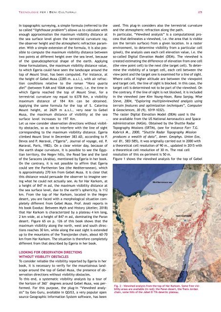
what he could not actually see. As for Har Karkom, at<br />
a height of 847 m asl, the maximum visibility distance at<br />
the sea surface level, due to the earth’s sphericity, is 112<br />
km. From the top of Har Karkom, located in the Negev<br />
desert, you are faced with a morphological situation completely<br />
different from Gebel Musa. Prof. Anati reports in<br />
his book Exodus: Between Myth and History (Atelier, 2018)<br />
that Har Karkom is characterized by a plateau 4 km long,<br />
2 km wide, at a height of 847 m asl, dominating the Paran<br />
desert. Figure 65 on p. 126 of this book shows that the<br />
maximum visibility along the north, west and south directions<br />
reaches 30 km, while along the east sight is extended<br />
up to the mountains of the Transjordan chain, about 60-70<br />
km from Har Karkom. The situation is therefore completely<br />
different from that described by Egeria in her book.<br />
LOOKING FOR OBSERVATION DIRECTIONS<br />
WITHOUT VISIBILITY OBSTACLES<br />
To consider reliable the visibility reported by Egeria in her<br />
book, it is necessary to verify for the mountainous landscape<br />
around the top of Gebel Musa, the presence of observation<br />
directions without visibility obstacles.<br />
To this end, a systematic visibility analysis by a tour of<br />
the horizon of 360° degrees around Gebel Musa, was performed.<br />
For this purpose, the plug-in “Viewshed analysis”<br />
by Geo Guru, available in QGIS3, a very popular open<br />
source Geographic Information System software, has been<br />
used. This plug-in considers also the terrestrial curvature<br />
and the atmospheric refraction along the path.<br />
In particular, “Viewshed analysis” is a computational process<br />
that delineates a viewshed, i.e. the area that is visible<br />
(on the terrain surface) from a given location. In a raster<br />
environment, to determine visibility from a particular cell<br />
(pixel), the analysis uses each cell elevation value, i.e. the<br />
so-called Digital Elevation Model (DEM). The viewshed is<br />
created estimating the difference of elevation from one cell<br />
(the view point cell) to the next (the target cell). To determine<br />
the visibility of a target cell, each cell between the<br />
view point and the target one is examined for a line of sight.<br />
Where cells of higher altitude are between the viewpoint<br />
and target cell, the line of sight is blocked. In this case, the<br />
target cell is determined not to be part of the viewshed. On<br />
the contrary, if the line of sight is not blocked, it is included<br />
in the viewshed (see Kim Young-Hoon, Rana Sanjay, Wise<br />
Steve, 2004, “Exploring multipleviewshed analysis using<br />
terrain features and optimization techniques”, Computer<br />
& Geosciences, 30 (9), 1019-1032).<br />
The raster Digital Elevation Model (DEM) used is the<br />
one available from the US National Aeronautics and Space<br />
Administration (NASA). Obtained by the Shuttle Radar<br />
Topography Missions (SRTM), (see for instance Farr T.G.<br />
Kobrick M., 2000, “Shuttle Radar Topography Mission<br />
produces a wealth of data”, Amer. Geophys. Union Eos,<br />
vol 81, 583-585), it was originally carried out in 2000 with<br />
a theoretical cell resolution of 90 m., updated in 2015 with<br />
a theoretical cell resolution of 30 m. The real cell<br />
resolution of this ex-periment is 50 m.<br />
Figure 1 shows the viewshed analysis for the top of Gebel<br />
Fig. 2 - Viewshed analysis from the top of Har Karkom. Some free visibility<br />
areas are available (in red): the Paran desert, the Trans Jordan<br />
chain, some hills of the Jebel El Tih desertic plateau.


