Archeomatica 4 2022 - Landscape Visibility

Create successful ePaper yourself
Turn your PDF publications into a flip-book with our unique Google optimized e-Paper software.
Musa (view point) extended up a the distance of 180 Km. As<br />
it is possible to see, despite the mountainous morphology of<br />
this area, there exist some directions of free visibility.<br />
In particular, some directions towards the Gulf of Suez and<br />
the Egyptian coast, the northern part of the Gulf of Aqaba<br />
and the Jordan coast, the Red Sea and part of Arabia in the<br />
south- western direction from Gebel Musa have free visibility,<br />
satisfying that reported in the book of Egeria.<br />
Furthermore, from Figure 1 it is possible to note some limited<br />
visibility areas in correspondence of the hills of the Negev<br />
desert, in the direction of Har Karkom. It is noteworthy<br />
that then, the visibility along the North direction from<br />
Gebel Musa allows seeing the Jebel El Tih desertic<br />
plateau, char-acterizing the central part of the Sinai<br />
Peninsula. Of course, Egeria could not see the Parthenion<br />
Sea (Mediterranean), 270 Km from Gebel Musa.<br />
Moving on to the Har Karkom, we are faced with a completely<br />
different situation. Figure 2 shows that from the top<br />
of Har Karkom it is possible to have a wide vision of the<br />
Paran desert, located at the south- southeast of Har Karkom.<br />
Also the mountains of the Trans-Jordan chain, placed<br />
east of the Aravà valley, are visible, from the Gulf of Aqaba<br />
until the Dead Sea.<br />
Furthermore, from Har Karkom there is a good visibility of<br />
the hills of the Jebel El Tih desertic plateau, in the central<br />
part of the Sinai Peninsula. The visibility situation is<br />
therefore completely different from what reported in the<br />
Egeria’s book.<br />
CONCLUSIONS<br />
According to the results, it clearly emerges that the<br />
mountain climbed by Egeria is Gebel Musa and not Har Karkom,<br />
an assumption that can be scientifically hown considering<br />
the landscape visibility from the top described by Egeria.<br />
However, it cannot be said from the other descriptions<br />
offered by the pilgrim about the approach to the mountain,<br />
its climb and descent, that have induced some to think that<br />
Egeria, in reality, did not climbed Gebel Musa.<br />
In any case, some descriptions of the climbing to the top of<br />
mount Sinai by Egeria are analogous to those reported by frà<br />
Niccolò da Poggibonsi, an italian Franciscan of the XIV century,<br />
who travelled to Holy Land in the years 1345-1350 and<br />
that had the opportunity to climb the top of Gebel Musa and<br />
and Mount S. Caterina. The story of his travel was reported<br />
in the “Libro d’Oltremare”, written by the friar after his<br />
return to Italy and subsequently published by Alberto Bacchi<br />
della Lega, in Bologna in 1881. In reference to the landscape<br />
visibility from the top of the mount S. Caterina, frà Niccolo<br />
writes in his book “From this place you can see Mount Sinai,<br />
and also the Red Sea, where the people of Israel passed and<br />
where the Pharaoh and his army were submerged; and also<br />
Arabia and the land of Egypt. On the top of the mountain we<br />
sang aloud: Salve Regina.<br />
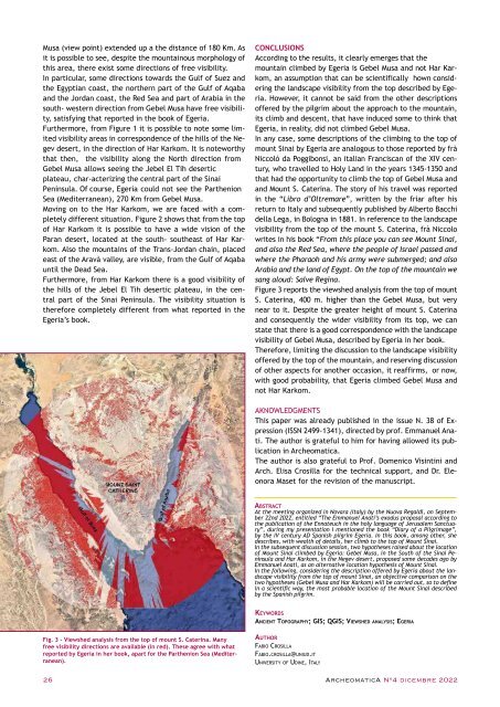
Figure 3 reports the viewshed analysis from the top of mount<br />
S. Caterina, 400 m. higher than the Gebel Musa, but very<br />
near to it. Despite the greater height of mount S. Caterina<br />
and consequently the wider visibility from its top, we can<br />
state that there is a good correspondence with the landscape<br />
visibility of Gebel Musa, described by Egeria in her book.<br />
Therefore, limiting the discussion to the landscape visibility<br />
offered by the top of the mountain, and reserving discussion<br />
of other aspects for another occasion, it reaffirms, or now,<br />
with good probability, that Egeria climbed Gebel Musa and<br />
not Har Karkom.<br />
AKNOWLEDGMENTS<br />
This paper was already published in the issue N. 38 of Expression<br />
(ISSN 2499-1341), directed by prof. Emmanuel Anati.<br />
The author is grateful to him for having allowed its publication<br />
in <strong>Archeomatica</strong>.<br />
The author is also grateful to Prof. Domenico Visintini and<br />
Arch. Elisa Crosilla for the technical support, and Dr. Eleonora<br />
Maset for the revision of the manuscript.<br />
Abstract<br />
At the meeting organized in Novara (Italy) by the Nuova Regaldi, on September<br />
22nd <strong>2022</strong>, entitled “The Emmanuel Anati’s exodus proposal according to<br />
the publication of the Ennateuch in the holy language of Jerusalem Sanctuary”,<br />
during my presentation I mentioned the book “Diary of a Pilgrimage”,<br />
by the IV century AD Spanish pilgrim Egeria. In this book, among other, she<br />
describes, with wealth of details, her climb to the top of Mount Sinai.<br />
In the subsequent discussion session, two hypotheses raised about the location<br />
of Mount Sinai climbed by Egeria: Gebel Musa, in the South of the Sinai Peninsula<br />
and Har Karkom, in the Negev desert, proposed some decades ago by<br />
Emmanuel Anati, as an alternative location hypothesis of Mount Sinai.<br />
In the following, considering the description offered by Egeria about the landscape<br />
visibility from the top of mount Sinai, an objective comparison on the<br />
two hypotheses (Gebel Musa and Har Karkom) will be carried out, so to define<br />
in a scientific way, the most probable location of the Mount Sinai described<br />
by the Spanish pilgrim.<br />
Keywords<br />
Ancient Topography; GIS; QGIS; Viewshed analysis; Egeria<br />
Fig. 3 - Viewshed analysis from the top of mount S. Caterina. Many<br />
free visibility directions are available (in red). These agree with what<br />
reported by Egeria in her book, apart for the Parthenion Sea (Mediterranean).<br />
Author<br />
Fabio Crosilla<br />
Fabio.crosilla@uniud.it<br />
University of Udine, Italy<br />
26 ArcheomaticA N°4 dicembre <strong>2022</strong>