
Sie wollen auch ein ePaper? Erhöhen Sie die Reichweite Ihrer Titel.
YUMPU macht aus Druck-PDFs automatisch weboptimierte ePaper, die Google liebt.
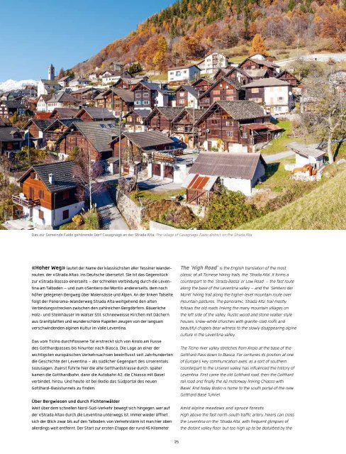
Das zur Gemeinde Faido gehörende Dorf Cavagnago an der Strada Alta. The village of Cavagnago, Faido district, on the Strada Alta.<br />
«Hoher Weg» lautet der Name der klassischsten aller Tessiner Wanderrouten,<br />
der «Strada Alta», ins Deutsche übersetzt. Sie ist das Gegenstück<br />
zur «Strada Bassa» einerseits – der schnellen Verbindung durch die Leventina<br />
am Talboden – und zum «Sentiero dei Monti» andererseits, dem noch<br />
höher gelegenen Bergweg über Maiensässe und Alpen. An der linken Talseite<br />
folgt der Panorama-Wanderweg Strada Alta weitgehend den alten<br />
Verbindungsstrecken zwischen den zahlreichen Bergdörfern. Bäuerliche<br />
Holz- und Steinhäuser im Walser Stil, schneeweisse Kirchen mit Dächern<br />
aus Granitplatten und wunderschöne Kapellen zeugen von der langsam<br />
verschwindenden alpinen Kultur im Valle Leventina.<br />
Das vom Ticino durchflossene Tal erstreckt sich von Airolo am Fusse<br />
des Gotthardpasses bis hinunter nach Biasca. Die Lage an einer der<br />
wichtigsten europäischen Verkehrsachsen beeinflusst seit Jahrhunderten<br />
die Geschichte der Leventina – als südlicher Gegenpart des Urserentals<br />
sozusagen. Zuerst führte hier die alte Gotthardstrasse durch, später<br />
kamen die Gotthardbahn, dann die Autobahn A2, die Chiasso mit Basel<br />
verbindet, hinzu. Und heute ist bei Bodio das Südportal des neuen<br />
Gotthard-Basistunnels zu finden.<br />
Über Bergwiesen und durch Fichtenwälder<br />
Weit über dem schnellen Nord-Süd-Verkehr bewegt sich hingegen, wer auf<br />
der «Strada Alta» durch die Leventina unterwegs ist. Immer wieder öffnet<br />
sich der Blick zwar bis auf den Talboden, von Verkehrslärm ist man hier oben<br />
allerdings weit entfernt. Der Start zur ersten Etappe der rund 45 Kilometer<br />
The 'High Road' is the English translation of the most<br />
classic of all Ticinese hiking trails, the 'Strada Alta'. It forms a<br />
counterpart to the 'Strada Bassa' or Low Road – the fast route<br />
along the base of the Leventina valley – and the 'Sentiero dei<br />
Monti' hiking trail along the higher-level mountain route over<br />
mountain pastures. The panoramic 'Strada Alta' trail mostly<br />
follows the old roads linking the many mountain villages on<br />
the left side of the valley. Rustic wood and stone Walser style<br />
houses, snow-white churches with granite-clad roofs and<br />
beautiful chapels bear witness to the slowly disappearing alpine<br />
culture in the Leventina valley.<br />
The Ticino river valley stretches from Airolo at the base of the<br />
Gotthard Pass down to Biasca. For centuries its position at one<br />
of Europe's key communication axes, as a sort of southern<br />
counterpart to the Urseren valley, has influenced the history of<br />
Leventina. First came the old Gotthard road, then the Gotthard<br />
rail road and finally the A2 motorway linking Chiasso with<br />
Basel. And today Bodio is home to the south portal of the new<br />
Gotthard Base Tunnel.<br />
Amid alpine meadows and spruce forests<br />
High above the fast north-south traffic artery, hikers can cross<br />
the Leventina on the 'Strada Alta', with frequent glimpses of<br />
the distant valley floor, but too high up to be disturbed by the<br />
25