Soil Management Handbook - Ministry of Agriculture and Lands
Soil Management Handbook - Ministry of Agriculture and Lands
Soil Management Handbook - Ministry of Agriculture and Lands
Create successful ePaper yourself
Turn your PDF publications into a flip-book with our unique Google optimized e-Paper software.
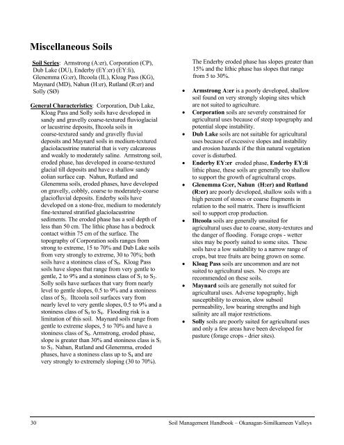
Miscellaneous <strong>Soil</strong>s<br />
<strong>Soil</strong> Series: Armstrong (A:er), Corporation (CP),<br />
Dub Lake (DU), Enderby (EY:er) (EY:li),<br />
Glenemma (G:er), Iltcoola (IL), Kloag Pass (KG),<br />
Maynard (MD), Nahun (H:er), Rutl<strong>and</strong> (R:er) <strong>and</strong><br />
Solly (SØ)<br />
General Characteristics: Corporation, Dub Lake,<br />
Kloag Pass <strong>and</strong> Solly soils have developed in<br />
s<strong>and</strong>y <strong>and</strong> gravelly coarse-textured fluvioglacial<br />
or lacustrine deposits, Iltcoola soils in<br />
coarse-textured s<strong>and</strong>y <strong>and</strong> gravelly fluvial<br />
deposits <strong>and</strong> Maynard soils in medium-textured<br />
glaciolacustrine material that is very calcareous<br />
<strong>and</strong> weakly to moderately saline. Armstrong soil,<br />
eroded phase, has developed in coarse-textured<br />
glacial till deposits <strong>and</strong> have a shallow s<strong>and</strong>y<br />
eolian surface cap. Nahun, Rutl<strong>and</strong> <strong>and</strong><br />
Glenemma soils, eroded phases, have developed<br />
on gravelly, cobbly, coarse to moderately-coarse<br />
glaci<strong>of</strong>luvial deposits. Enderby soils have<br />
developed on a stone-free, medium to moderately<br />
fine-textured stratified glaciolacustrine<br />
sediments. The eroded phase has a soil depth <strong>of</strong><br />
less than 50 cm. The lithic phase has a bedrock<br />
contact within 75 cm <strong>of</strong> the surface. The<br />
topography <strong>of</strong> Corporation soils ranges from<br />
strong to extreme, 15 to 70% <strong>and</strong> Dub Lake soils<br />
from very strongly to extreme, 30 to 70%; both<br />
soils have a stoniness class <strong>of</strong> S0. Kloag Pass<br />
soils have slopes that range from very gentle to<br />
gentle, 2 to 9% <strong>and</strong> a stoniness class <strong>of</strong> S1 to S2.<br />
Solly soils have surfaces that vary from nearly<br />
level to gentle slopes, 0.5 to 9% <strong>and</strong> a stoniness<br />
class <strong>of</strong> S2. Iltcoola soil surfaces vary from<br />
nearly level to very gentle slopes, 0.5 to 9% <strong>and</strong> a<br />
stoniness class <strong>of</strong> S0 to S4. Flooding risk is a<br />
limitation <strong>of</strong> this soil. Maynard soils range from<br />
gentle to extreme slopes, 5 to 70% <strong>and</strong> have a<br />
stoniness class <strong>of</strong> S0. Armstrong, eroded phase,<br />
slope is greater than 30% <strong>and</strong> stoniness class is S1<br />
to S3. Nahun, Rutl<strong>and</strong> <strong>and</strong> Glenemma, eroded<br />
phases, have a stoniness class up to S4 <strong>and</strong> are<br />
very strongly to extremely sloping (30 to 70%).<br />
The Enderby eroded phase has slopes greater than<br />
15% <strong>and</strong> the lithic phase has slopes that range<br />
from 5 to 30%.<br />
• Armstrong A:er is a poorly developed, shallow<br />
soil found on very strongly sloping sites which<br />
are not suited to agriculture.<br />
• Corporation soils are severely constrained for<br />
agricultural uses because <strong>of</strong> steep topography <strong>and</strong><br />
potential slope instability.<br />
• Dub Lake soils are not suitable for agricultural<br />
uses because <strong>of</strong> excessive slopes <strong>and</strong> instability<br />
<strong>and</strong> erosion hazards if the thin natural vegetation<br />
cover is disturbed.<br />
• Enderby EY:er eroded phase, Enderby EY:li<br />
lithic phase, these soils are generally too shallow<br />
to support the growth <strong>of</strong> agricultural crops.<br />
• Glenemma G:er, Nahun (H:er) <strong>and</strong> Rutl<strong>and</strong><br />
(R:er) are poorly developed, shallow soils with a<br />
high percent <strong>of</strong> stones or coarse fragments in<br />
relation to the soil matrix. There is insufficient<br />
soil to support crop production.<br />
• Iltcoola soils are generally unsuited for<br />
agricultural uses due to coarse, stony-textures <strong>and</strong><br />
the danger <strong>of</strong> flooding. Forage crops - wetter<br />
sites may be poorly suited to some sites. These<br />
soils have a low suitability to a narrow range <strong>of</strong><br />
crops, but tree fruits are being grown on some.<br />
• Kloag Pass soils are uncommon <strong>and</strong> are not<br />
suited to agricultural uses. No crops are<br />
recommended on these soils.<br />
• Maynard soils are generally not suited for<br />
agricultural uses. Adverse topography, high<br />
susceptibility to erosion, slow subsoil<br />
permeability, low bearing strengths <strong>and</strong> high<br />
salinity are all major restrictions.<br />
• Solly soils are poorly suited for agricultural uses<br />
<strong>and</strong> only a few areas have been developed for<br />
pasture (forage crops - drier sites).<br />
30 <strong>Soil</strong> <strong>Management</strong> <strong>H<strong>and</strong>book</strong> – Okanagan-Similkameen Valleys


