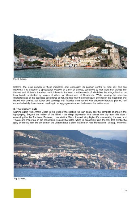
Fig. 6: Cetara. Salerno, the large number of these industries <strong>and</strong>, especially, its position central to road, rail <strong>and</strong> sea networks. It is placed in a spectacular location on a sort of plateau, contained by high walls that plunge into the sea <strong>and</strong> Molina in the river - which flows to the west - to the mouth of which lies the village Marina, on long beach, protected by towers of Albori, of Marina <strong>and</strong> of Crestarella. While treating the common characteristics of the countries considered so far, starting with the picturesque, perched in the most high <strong>and</strong> dotted with domes, bell tower <strong>and</strong> buildings with facades ornamented with elaborate baroque plaster, has exp<strong>and</strong>ed wildly downstream, resulting in an aggregate compact that covers the entire slope. 3. The western side Starting again from Amalfi Coast to the west of the section, we can easily see the complete change in the topography. Beyond the valley of the Blind - the deep depression that closes the city from this side - extending the five fractions, Pastena, Lone Vettica Minor, located atop high cliffs overlooking the sea, <strong>and</strong> Tovere <strong>and</strong> Pogerola, in the mountains. Except the latter, which is accessible from the trail that climbs the gully or directly from the city center, the villages have a plant in a line on road Maestra dei Villaggi, the most Fig. 7: Vietri. 1113
Fig. 8: Furore,Conca dei Marini <strong>and</strong> Tovere (Amalfi), plan. important medieval road this side, on which st<strong>and</strong> the greatest architectural episodes religious <strong>and</strong> civil [5]. The road winds with ramps, curbs <strong>and</strong> rare flat sections, complying as much as possible the lines of lower slope <strong>and</strong>, after crossing the maritime towns, shall be directed to Tovere <strong>and</strong> from there to Agerola. It brings together on steep routes, which cut perpendicular to contour lines, from the mountain <strong>and</strong> the coast, stretching up to the furthest reaches of the settlement. Even here, the plot is still legible traditional road, despite multiple impairments introduced by vehicular arteries, first of all, the Amalfi-Agerola, which penetrates Vettica Minor with straight line segments <strong>and</strong> curves. Those villages have mainly concentrated on the main road blocks <strong>and</strong> lower transverse or parallel in some cases, denoting the linear form is typical of this area. The first one, Conca dei Marini, repeats the same orography. Arranged according to an ancient chronicler, "on the face of a steep mountain", is bolted to the north by high cliffs, steep cliffs to the south <strong>and</strong> from east <strong>and</strong> west by deep valleys. The conformation fostered the creation of small groups scattered in the most hospitable (m 180-280 above sea level) <strong>and</strong> a tiny nucleus of the sea, where he was a natural harbor, until the mid nineteenth century among the few sheltered harbors near Amalfi [6]. The town assumed an elongated configuration on the edges of the road - now almost entirely made carriage - which, by accounting for the slope, through the whole municipal area from east to west, receiving from the upstream <strong>and</strong> downstream laborious steps, called "petigni" <strong>and</strong> touching around which the three parishes in the Middle Ages settled urban cores: St. Maria of Grado - be abolished <strong>and</strong> incorporated at the end of the seventeenth century in the conservatory of St. Rosa - St. Antonio <strong>and</strong> St. Michele Arcangelo. The walk, starting from the far east of Grado, placed in the highest, was heading west to Penna, bordering Furore. About half of the course, met the square of the Elm, the only open space l<strong>and</strong>, from which started the link with the largest settlement, extended on the promontory called "Vreca" <strong>and</strong> relating to the fourth parish, St. Pancrazio. From there, it branched off to the Cape, where later was erected the tower, Viceroy, <strong>and</strong> from the Navy. Fortunately, the Amalfi-Agerola interferes little with the villages, <strong>and</strong> remained almost as high, however, has made the village Grado, once the most isolated <strong>and</strong> inaccessible, accessible directly by car. Furore extends west, beyond the deep ravine where the stream flows Schiatro, which flows into the famous fiord, on which, in the late nineteenth century, was built the bold single-span bridge of today's SS. 163. The soil, which rises from the sea to share about 600 meters of the plateau of Agerola, is characterized by an exceptional southern exposure <strong>and</strong> a strong steepness, which makes it extremely difficult journey [7]. Despite the deep changes brought about by the Agerola-Amalfi, you can still recognize the old distribution scattered in small sets, which is associated with that of last century, set along the road <strong>and</strong> in the immediate vicinity, as far as possible in order to facilitate the approach [2]. From the few houses at the mouth, the steep staircase climbs the ridge to about 300 meters, after which it divides into two branches. The first goes north <strong>and</strong> then west to the houses surrounding the church of St. Elijah (about m 250 above sea level), continuing to the north with steep straight lines <strong>and</strong> zig zags, orthogonally facing the ascent to below Agerola. The second was the same way the slope, leading to the three villages belonging to the churches of St. James, St. Michael <strong>and</strong> St. Maria of Pieta, linked by narrow longitudinal parallel <strong>and</strong> continues up to the plateau. 1114
- Page 1 and 2: Archaeology and nature: hyblean cul
- Page 3 and 4: 2. Kaukana project: territorial reg
- Page 5 and 6: The main goal of the planning inter
- Page 7 and 8: The Time of Flight 3d laser scanner
- Page 9 and 10: Fig. 12-13: The archaeological land
- Page 11 and 12: Industrial heritage, collective ide
- Page 13 and 14: vertical reduction of market prices
- Page 15 and 16: Fig. 3: The mining site of Grottaca
- Page 17 and 18: Fig. 5: Laser scan 3D of the Pozzo
- Page 19 and 20: Fig. 6: Palazzo Pennisi. meanings,
- Page 21 and 22: Le tanneries di Barjols: uno spazio
- Page 23 and 24: Fig. 2 - Piano del quartiere delle
- Page 25 and 26: Fig. 4 - Sviluppo verticale anni ci
- Page 27 and 28: Riferimenti bibliografici [1] AA.VV
- Page 29 and 30: to compact settlements, in which th
- Page 31: Fig. 4: Maiori, plan 1848. Fig. 5:
- Page 35 and 36: Fig. 10: Positano. 4. The mountain
- Page 37 and 38: which the driving force derived fro
- Page 39 and 40: The urban development of the lower
- Page 41 and 42: Fig. 2: Roman time, overlap Paget h
- Page 43 and 44: Fig. 4: 3D model, a. Greek time, b.
- Page 45 and 46: Fig. 6: Acropolis of Cuma Overlappi
- Page 47 and 48: We think that 3D PDF could be an us
- Page 49 and 50: having an infrastructure in a certa
- Page 51 and 52: Cana le Pic. 3 Territorial context
- Page 53 and 54: Shape: 1. Bridge dimensions and sha
- Page 55 and 56: AUGÉ Marc. Nonluoghi - introduzion
- Page 57 and 58: productive landscape design restric
- Page 59 and 60: Tehran’s outskirt Fig.4, 5: Agric
- Page 61 and 62: Appropriate interaction among urban
- Page 63 and 64: Allotment garden: is designed for t
- Page 65 and 66: 5. Conclusion Restoration of biodiv
- Page 67 and 68: irrepressible expression of a cultu
- Page 69 and 70: The competition titled Pylons of th
- Page 71 and 72: Fig. 9: An iconographic repertory o
- Page 73 and 74: Camillo Sitte meets Robert Venturi
- Page 75 and 76: Fig. 1: Berlin southern beltway at
- Page 77 and 78: The design of sustainability in rel
- Page 79 and 80: To safeguard fertile, dynamic and a
- Page 81 and 82: “The loss of place, asserts Chris
- Page 83 and 84:
3. Sustainable morphology as integr
- Page 85 and 86:
In truth, we are witnessing today -
- Page 87 and 88:
Recognizing Cultural Heritage for S
- Page 89 and 90:
emember our past. The relationship
- Page 91 and 92:
State’s social offer (health, edu
- Page 93 and 94:
Besides, the achievements of this u
- Page 95 and 96:
evident the impact the park had on