Archaeology and nature: hyblean cultural landscape and territorial ...
Archaeology and nature: hyblean cultural landscape and territorial ...
Archaeology and nature: hyblean cultural landscape and territorial ...

You also want an ePaper? Increase the reach of your titles
YUMPU automatically turns print PDFs into web optimized ePapers that Google loves.
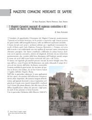
Fig. 8: Furore,Conca dei Marini <strong>and</strong> Tovere (Amalfi), plan.<br />
important medieval road this side, on which st<strong>and</strong> the greatest architectural episodes religious <strong>and</strong> civil [5].<br />
The road winds with ramps, curbs <strong>and</strong> rare flat sections, complying as much as possible the lines of lower<br />
slope <strong>and</strong>, after crossing the maritime towns, shall be directed to Tovere <strong>and</strong> from there to Agerola. It brings<br />
together on steep routes, which cut perpendicular to contour lines, from the mountain <strong>and</strong> the coast,<br />
stretching up to the furthest reaches of the settlement. Even here, the plot is still legible traditional road,<br />
despite multiple impairments introduced by vehicular arteries, first of all, the Amalfi-Agerola, which<br />
penetrates Vettica Minor with straight line segments <strong>and</strong> curves.<br />
Those villages have mainly concentrated on the main road blocks <strong>and</strong> lower transverse or parallel in some<br />
cases, denoting the linear form is typical of this area.<br />
The first one, Conca dei Marini, repeats the same orography. Arranged according to an ancient chronicler,<br />
"on the face of a steep mountain", is bolted to the north by high cliffs, steep cliffs to the south <strong>and</strong> from east<br />
<strong>and</strong> west by deep valleys. The conformation fostered the creation of small groups scattered in the most<br />
hospitable (m 180-280 above sea level) <strong>and</strong> a tiny nucleus of the sea, where he was a natural harbor, until<br />
the mid nineteenth century among the few sheltered harbors near Amalfi [6].<br />
The town assumed an elongated configuration on the edges of the road - now almost entirely made carriage<br />
- which, by accounting for the slope, through the whole municipal area from east to west, receiving from the<br />
upstream <strong>and</strong> downstream laborious steps, called "petigni" <strong>and</strong> touching around which the three parishes in<br />
the Middle Ages settled urban cores: St. Maria of Grado - be abolished <strong>and</strong> incorporated at the end of the<br />
seventeenth century in the conservatory of St. Rosa - St. Antonio <strong>and</strong> St. Michele Arcangelo. The walk,<br />
starting from the far east of Grado, placed in the highest, was heading west to Penna, bordering Furore.<br />
About half of the course, met the square of the Elm, the only open space l<strong>and</strong>, from which started the link<br />
with the largest settlement, extended on the promontory called "Vreca" <strong>and</strong> relating to the fourth parish, St.<br />
Pancrazio. From there, it branched off to the Cape, where later was erected the tower, Viceroy, <strong>and</strong> from the<br />
Navy. Fortunately, the Amalfi-Agerola interferes little with the villages, <strong>and</strong> remained almost as high,<br />
however, has made the village Grado, once the most isolated <strong>and</strong> inaccessible, accessible directly by car.<br />
Furore extends west, beyond the deep ravine where the stream flows Schiatro, which flows into the famous<br />
fiord, on which, in the late nineteenth century, was built the bold single-span bridge of today's SS. 163. The<br />
soil, which rises from the sea to share about 600 meters of the plateau of Agerola, is characterized by an<br />
exceptional southern exposure <strong>and</strong> a strong steepness, which makes it extremely difficult journey [7].<br />
Despite the deep changes brought about by the Agerola-Amalfi, you can still recognize the old distribution<br />
scattered in small sets, which is associated with that of last century, set along the road <strong>and</strong> in the immediate<br />
vicinity, as far as possible in order to facilitate the approach [2]. From the few houses at the mouth, the steep<br />
staircase climbs the ridge to about 300 meters, after which it divides into two branches. The first goes north<br />
<strong>and</strong> then west to the houses surrounding the church of St. Elijah (about m 250 above sea level), continuing<br />
to the north with steep straight lines <strong>and</strong> zig zags, orthogonally facing the ascent to below Agerola. The<br />
second was the same way the slope, leading to the three villages belonging to the churches of St. James, St.<br />
Michael <strong>and</strong> St. Maria of Pieta, linked by narrow longitudinal parallel <strong>and</strong> continues up to the plateau.<br />
1114