- Page 1 and 2:
Copyright by Nysha Chaderton 2009
- Page 3 and 4:
Sedimentation within the Tobago For
- Page 5 and 6:
Acknowledgements I would like to th
- Page 7 and 8:
Table of Contents List of Tables ..
- Page 9 and 10:
List of Tables Table 2.1: Latitudes
- Page 11 and 12:
Figure 2.14: Planar parallel lamina
- Page 13 and 14:
Figure 2.42: Coarse, cobble and peb
- Page 15 and 16:
Figure A.3a: Chalky Mount Ridge mea
- Page 17 and 18:
1. Development history of the south
- Page 19 and 20:
Formation. This interpretation requ
- Page 21 and 22:
DATA AND METHODOLOGY Extensive work
- Page 23 and 24:
DESCRIPTIVE METHODOLOGY Each sectio
- Page 25 and 26:
Two or more channel complexes stack
- Page 27 and 28:
These poorly sorted sands are later
- Page 29 and 30:
East Coast Road Although the East C
- Page 31 and 32:
succession of interlaminated siltst
- Page 33 and 34:
Mount All The beds of the Mount All
- Page 35 and 36:
Lobes are non-channelized bodies, 3
- Page 37 and 38:
Sandy units are the most resistant
- Page 39 and 40:
SUMMARY DEPOSITIONAL SETTING OF THE
- Page 41 and 42:
Chapter Three: Petrographic Analysi
- Page 43 and 44:
had not been buried deeply or long
- Page 45 and 46:
Feldspars Calcium Plagioclase Felds
- Page 47 and 48:
Authigenic Minerals Authigenic mine
- Page 49 and 50:
amounts of chlorite and kaolinite c
- Page 51 and 52:
Sample: WRA 16 This sample was take
- Page 53 and 54:
cementation is observed. A number o
- Page 55 and 56:
COMPARISON WITH PREVIOUS WORK Punch
- Page 57 and 58:
K feldspar preservation to slightly
- Page 59 and 60:
CONCLUSIONS 1. No quartz cementatio
- Page 61 and 62:
The highest point of the island, is
- Page 63 and 64:
STRATIGRAPHIC FRAMEWORK ONSHORE TO
- Page 65 and 66:
STRUCTURAL FRAMEWORK OF THE BARBADO
- Page 67 and 68:
Sandy material is primarily quartz
- Page 69 and 70:
esult of extension caused by flexur
- Page 71 and 72:
1994). The origin of the Oceanic Fo
- Page 73 and 74:
Oligocene-age sediments are deposit
- Page 75 and 76:
The observation of channel geometri
- Page 77 and 78:
Pudsey, (1982) interpreted smectite
- Page 79 and 80:
The interpretation of the Scotland
- Page 81 and 82:
Figure 1.2: Convergent margins arou
- Page 83 and 84:
NSF Study Lines Grenada St. Kitts S
- Page 85 and 86:
Figure 2.2: Generalized vertical se
- Page 87 and 88:
Figure 2.4: Detailed Geological map
- Page 89 and 90:
Figure 2.6: Photographs and illustr
- Page 91 and 92:
Figure 2.8: Bedsets on the channel
- Page 93 and 94:
S 50 m Figure 2.10: Photo-panorama
- Page 95 and 96:
Figure 2.13: Laminated silt and mud
- Page 97 and 98:
Figure 2.16a: Measured section at C
- Page 99 and 100:
Figure 2.16c: Measured section at C
- Page 101 and 102:
Figure 2.18: Correlation of section
- Page 103 and 104:
Figure 2.21: Parallel laminated sil
- Page 105 and 106:
Wach, Vincent and Chaderton March 2
- Page 107 and 108: Wach, Vincent and Chaderton March 2
- Page 109 and 110: Wach, Vincent and Chaderton March 2
- Page 111 and 112: Figure 2.24: Channel element identi
- Page 113 and 114: WRB S N Fresh rock face exposed by
- Page 115 and 116: Figure 2.28: Photograph of Diplocra
- Page 117 and 118: Figure 2.31: Conglomerate with eros
- Page 119 and 120: Figure 2.33: Thalassinoides trace f
- Page 121 and 122: Figure 2.35: Mount All measured str
- Page 123 and 124: Figure 2.37: Medium grained sand be
- Page 125 and 126: Figure 2.38b: Inner Turner’s Hall
- Page 127 and 128: Figure 2.38d: Inner Turner’s Hall
- Page 129 and 130: Figure 2.39: Spa Hill measured stra
- Page 131 and 132: Juniper Ridge, California Scotland
- Page 133 and 134: Figure 3.1: Fractured quartz grain
- Page 135 and 136: SGRF 1C SGRF 9C Figure 3.5: Measure
- Page 137 and 138: Figure 3.8: Photo of sample SGRF 11
- Page 139 and 140: Figure 3.10: Photo of sample SGRF 1
- Page 141 and 142: Figure 3.12: Photo of sample WRA 16
- Page 143 and 144: Figure 3.14: Photo of sample WRB 8
- Page 145 and 146: Figure 3.16: Photo of sample ITR 9
- Page 147 and 148: Figure 3.19: Photo of sample CMRA s
- Page 149 and 150: Figure 3. 23: Composition of Scotla
- Page 151 and 152: Figure 4.1: Base map showing seismi
- Page 153 and 154: Figure 4.3: Channels within Unit Fi
- Page 155 and 156: Figure 4.5: Seismic reflection prof
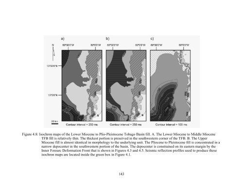
- Page 157: Figure 4.7 Isochron maps of the old
- Page 161 and 162: Figure 4.11: Illustration of Hypoth
- Page 163 and 164: necessary to clear a path. Keep to
- Page 165 and 166: 2006 Figure A.2a: Lidar Ridge measu
- Page 167 and 168: Figure A.3b: Chalky Mount Ridge mea
- Page 169 and 170: 2006 Figure A.4a: Chalky Mount Ridg
- Page 171 and 172: 2006 Figure A.4c: Chalky Mount Ridg
- Page 173 and 174: 2006 Figure A.6: Chalky Mount Ridge
- Page 175 and 176: Figure A.7b: Measured Section of Ch
- Page 177 and 178: 2006 Figure A.8a: Sleeping Giant Ri
- Page 179 and 180: 2006 Figure A.9: Sleeping Giant Rid
- Page 181 and 182: 2006 Figure A.11: Sleeping Giant Ri
- Page 183 and 184: Figure A.13a: Sleeping Giant Ridge
- Page 185 and 186: 2006 Figure A.14a: Coast Road Below
- Page 187 and 188: 2006 Figure A.14c: Coast Road Below
- Page 189 and 190: 2006 Figure A.14e: Coast Road Below
- Page 191 and 192: 2006 Figure A.14g: Coast Road Below
- Page 193 and 194: 2006 Figure A.15: Ermy Bourne Ridge
- Page 195 and 196: 2006 Figure A.17: Spa Hill Fold Mea
- Page 197 and 198: 2006 Figure A.19: Ermy Bourne Ridge
- Page 199 and 200: Figure A.20b: Walkers Ridge Measure
- Page 201 and 202: Figure A.21: Walkers Ridge Measured
- Page 203 and 204: Figure A.22b: Walkers Ridge Measure
- Page 205 and 206: 2007 Figure A.23b: Inner Turner’s
- Page 207 and 208: 2007 Figure A.23d: Inner Turner’s
- Page 209 and 210:
Framework grains Quartz Feldspar Ro
- Page 211 and 212:
CRIMES, T.P., 1977, Trace fossils o
- Page 213 and 214:
MONTGOMERY, S.L., BARKER, C.E., SEA
- Page 215 and 216:
RICHARDS, M., BOWMAN, M., and READI
- Page 217 and 218:
WEBER, J.C., DIXON, T.H., DEMETS, C