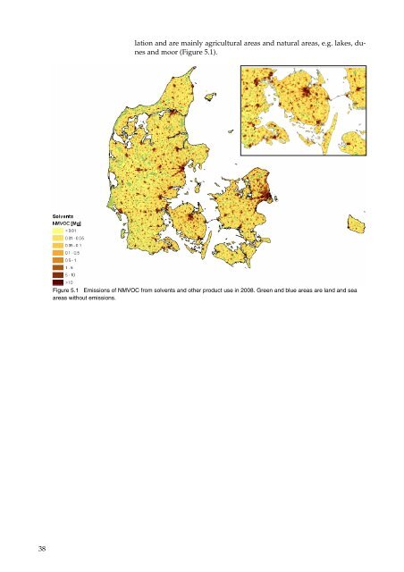
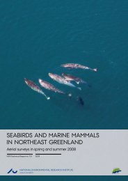
38 lation and are mainly agricultural areas and natural areas, e.g. lakes, dunes and moor (Figure 5.1). Figure 5.1 Emissions <strong>of</strong> NMVOC from solvents and o<strong>the</strong>r product use in 2008. Green and blue areas are land and sea areas without <strong>emissions</strong>.
6SDWLDO GLVWULEXWLRQ RI HPLVVLRQV IURP WKH $JULFXOWXUDO VHFWRU The Danish emission inven<strong>to</strong>ry for <strong>the</strong> agricultural sec<strong>to</strong>r covers five sub-sec<strong>to</strong>rs: 1. Enteric fermentation, which covers <strong>emissions</strong> <strong>of</strong> CH4 from animals’ digestion. 2. Manure management, which covers <strong>emissions</strong> <strong>of</strong> CH4, N2O, NH3 and PM from handling <strong>of</strong> manure in housings and during s<strong>to</strong>rage in slurry tanks and manure heaps. 3. Agricultural soils, which cover <strong>emissions</strong> <strong>of</strong> N2O from crop residues, N fixing crops, animal manure applied <strong>to</strong> soils, syn<strong>the</strong>tic fertiliser, leaching and run-<strong>of</strong>f, atmospheric deposition, N-excretion on pasture range and paddock, cultivation <strong>of</strong> his<strong>to</strong>sols and sludge applied <strong>to</strong> soils. Fur<strong>the</strong>r, agricultural soils cover NMVOC and NH3 from crops. 4. Field burning <strong>of</strong> agricultural residues covers <strong>emissions</strong> <strong>of</strong> all pollutants from field burning in <strong>the</strong> inven<strong>to</strong>ry system except CO2 as this is treated as biomass and HCB, which are not occurring. 5. O<strong>the</strong>r covers NH3 from sludge (including e.g. fruit juice and pota<strong>to</strong> juice e.g. from pota<strong>to</strong> flour plants). As <strong>the</strong> categorisation is different for UNFCCC and CLRTAP, emission from sludge is included in different categories in <strong>the</strong> two reporting formats; in Agricultural soils for UNFCCC and in O<strong>the</strong>r for CLRTAP. Prior <strong>to</strong> 2008 NH3 from sludge was allocated in <strong>the</strong> agricultural soils sub-sec<strong>to</strong>r in both reporting formats, but due <strong>to</strong> a shift <strong>to</strong> <strong>the</strong> new NFR categories from <strong>the</strong> 2008 reporting, <strong>the</strong> shift in sub-category was carried out. The emission inven<strong>to</strong>ry for <strong>the</strong> agricultural sec<strong>to</strong>r is using detailed methodologies and a large number <strong>of</strong> very detailed datasets, e.g. figures from Statistics Denmark, feedstuffs tables, normative feed consumption and nitrogen excretion figures, and data from <strong>the</strong> Central Husbandry Register (CHR) and <strong>the</strong> General Agriculture Register (GLR). The emission calculation is taking in<strong>to</strong> account a number <strong>of</strong> conditions related <strong>to</strong> e.g. animals, housings, manure management, litter, fodder, crops, use <strong>of</strong> fertiliser and sludge. The spatial <strong>distribution</strong> <strong>of</strong> <strong>emissions</strong> from agriculture is carried out separately for each source. The <strong>distribution</strong>s are based on a large amount <strong>of</strong> very detailed data, e.g. <strong>the</strong> CHR, GLR, <strong>the</strong> Land Parcel Identification System (LPIS) and <strong>the</strong> nitrogen accounts for each individual farmer. CHR holds information on <strong>the</strong> population and location <strong>of</strong> animals on a large number <strong>of</strong> animal-categories. GLR holds data on types <strong>of</strong> crops on field and farm level. LPIS hold <strong>the</strong> geographical location <strong>of</strong> all Danish agricultural soils. The land parcels are split by natural boundaries in <strong>the</strong> landscape, e.g. trenches, hedgerows and roads. Although one land parcels can cover one or more fields this dataset combined with GLR and CHR gives very detailed information on <strong>the</strong> location <strong>of</strong> fields, crops and animals. On average one land parcels covers approximately 11 hectares and includes three fields. 39