

Moose River Basin: geology and mineral potential - Geology Ontario
Moose River Basin: geology and mineral potential - Geology Ontario
Moose River Basin: geology and mineral potential - Geology Ontario

Create successful ePaper yourself
Turn your PDF publications into a flip-book with our unique Google optimized e-Paper software.
<strong>Moose</strong> <strong>River</strong> <strong>Basin</strong><br />
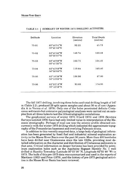
Drillhole<br />
Location<br />
Elevation<br />
(metres)<br />
Total Depth<br />
(metres)<br />
75-01<br />
85040'51"W<br />
50 0 21'43"N<br />
92.23<br />
45.73<br />
75-02<br />
82045'46"W<br />
500 35'27"N<br />
149.74<br />
130.18<br />
75-03<br />
82 048'08"W<br />
50041'35"N<br />
163.75<br />
134.45<br />
75-04<br />
820 43'03"W<br />
500 28'00"N<br />
119.64<br />
165.40<br />
75-05<br />
820 18'38"W<br />
500 10'05"N<br />
100.96<br />
87.80<br />
75-06<br />
82 0 23'13"W<br />
50 0 16'58"N<br />
93.66<br />
174.85<br />
The fall 1977 drilling, involving three holes <strong>and</strong> total drilling length of 147<br />
m (Table 2.2), produced 29 split spoon samples <strong>and</strong> about 50 m of core (Appen<br />
dix A in Verma et al. 1978). Only one of the holes penetrated definite Creta<br />
ceous sediments but extensive palynological analyses were carried out on sam<br />
ples from all three holes to test the lithostratigraphic correlations.<br />
The geophysical surveys of winter 1975 (Utard 1975) <strong>and</strong> 1976 (Scintrex<br />
Surveys Limited 1976) have had only limited value in interpretation of the Me<br />
sozoic stratigraphy. Perhaps of most use was the seismic profile obtained con<br />
currently with the winter 1975 drilling which indicated the approximate topog<br />
raphy of the Precambrian basement <strong>and</strong> overlying Paleozoic strata.<br />
In addition to this recently acquired data, a large body of geological inform<br />
ation has been generated by fossil fuel <strong>and</strong> industrial <strong>mineral</strong> exploration ac<br />
tivity in the <strong>Moose</strong> <strong>River</strong> <strong>Basin</strong> over the past 50 years. More than 400 boreholes<br />
have been drilled near Onakawana since the late 1920s, providing most de<br />
tailed information on the character <strong>and</strong> distribution of Cretaceous sediments in<br />
that area. Critical information on deeper horizons has been provided by petro<br />
leum exploration holes such as the Aquitaine Sogepet Hambly No. l well<br />
drilled in Hambly Township (Latitude 50015'16"N, Longitude 82035'48"W) in<br />
1973. The bulk of this pre-1975 data was summarized <strong>and</strong> used in the reports of<br />
Martison (1953) <strong>and</strong> Price (1978), <strong>and</strong> the history of pre-1975 geological activi<br />
ties in the <strong>Moose</strong> <strong>River</strong> <strong>Basin</strong> has been reviewed.<br />
26


