

Moose River Basin: geology and mineral potential - Geology Ontario
Moose River Basin: geology and mineral potential - Geology Ontario
Moose River Basin: geology and mineral potential - Geology Ontario

Create successful ePaper yourself
Turn your PDF publications into a flip-book with our unique Google optimized e-Paper software.
Mesozoic Stratigraphy<br />
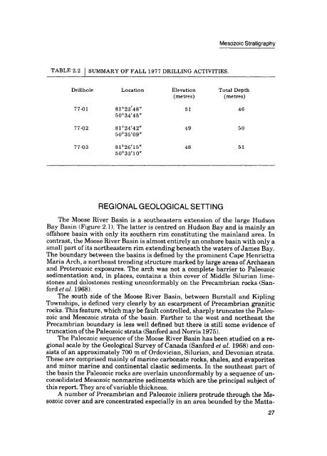
TABLE 2.2 l<br />
SUMMARY OF FALL 1977 DRILLING ACTIVITIES.<br />
Drillhole<br />
Location<br />
Elevation<br />
(metres)<br />
Total Depth<br />
(metres)<br />
77-01<br />
81 023'48"<br />
500 34'4B"<br />
51<br />
46<br />
77-02<br />
81 0 24'42"<br />
500 35'09"<br />
49<br />
50<br />
77-03<br />
81 0 26'15"<br />
500 33'10"<br />
48<br />
51<br />
REGIONAL GEOLOGICAL SETTING<br />
The <strong>Moose</strong> <strong>River</strong> <strong>Basin</strong> is a southeastern extension of the large Hudson<br />
Bay <strong>Basin</strong> (Figure 2.1). The latter is centred on Hudson Bay <strong>and</strong> is mainly an<br />
offshore basin with only its southern rim constituting the mainl<strong>and</strong> area. In<br />
contrast, the <strong>Moose</strong> <strong>River</strong> <strong>Basin</strong> is almost entirely an onshore basin with only a<br />
small part of its northeastern rim extending beneath the waters of James Bay.<br />
The boundary between the basins is defined by the prominent Cape Henrietta<br />
Maria Arch, a northeast trending structure marked by large areas of Archaean<br />
<strong>and</strong> Proterozoic exposures. The arch was not a complete barrier to Paleozoic<br />
sedimentation <strong>and</strong>, in places, contains a thin cover of Middle Silurian lime<br />
stones <strong>and</strong> dolostones resting unconformably on the Precambrian rocks (San<br />
ford et al. 1968).<br />
The south side of the <strong>Moose</strong> <strong>River</strong> <strong>Basin</strong>, between Burstall <strong>and</strong> Kipling<br />
Townships, is defined very clearly by an escarpment of Precambrian granitic<br />
rocks. This feature, which may be fault controlled, sharply truncates the Paleo<br />
zoic <strong>and</strong> Mesozoic strata of the basin. Farther to the west <strong>and</strong> northeast the<br />
Precambrian boundary is less well defined but there is still some evidence of<br />
truncation of the Paleozoic strata (Sanford <strong>and</strong> Norris 1975).<br />
The Paleozoic sequence of the <strong>Moose</strong> <strong>River</strong> <strong>Basin</strong> has been studied on a re<br />
gional scale by the Geological Survey of Canada (Sanford et al. 1968) <strong>and</strong> con<br />
sists of an approximately 700 m of Ordovician, Silurian, <strong>and</strong> Devonian strata.<br />
These are comprised mainly of marine carbonate rocks, shales, <strong>and</strong> evaporites<br />
<strong>and</strong> minor marine <strong>and</strong> continental clastic sediments. In the southeast part of<br />
the basin the Paleozoic rocks are overlain unconformably by a sequence of un<br />
consolidated Mesozoic nonmarine sediments which are the principal subject of<br />
this report. They are of variable thickness.<br />
A number of Precambrian <strong>and</strong> Paleozoic inliers protrude through the Me<br />
sozoic cover <strong>and</strong> are concentrated especially in an area bounded by the Matta-<br />
27


