

Moose River Basin: geology and mineral potential - Geology Ontario
Moose River Basin: geology and mineral potential - Geology Ontario
Moose River Basin: geology and mineral potential - Geology Ontario

You also want an ePaper? Increase the reach of your titles
YUMPU automatically turns print PDFs into web optimized ePapers that Google loves.
<strong>Moose</strong> <strong>River</strong> <strong>Basin</strong><br />
TABLE 3.1<br />
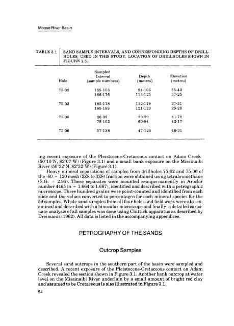
SAND SAMPLE INTERVALS, AND CORRESPONDING DEPTHS OF DRILL<br />
HOLES, USED IN THIS STUDY. LOCATION OF DRILLHOLES SHOWN IN<br />
FIGURE 1.3.<br />
Sampled<br />
Interval Depth Elevation<br />
Hole (sample numbers) (metres) (metres)<br />
75-02 125-153 94-106 55-43<br />
166-176 113-125 37-25<br />
75-03 165-178 112-119 37-31<br />
185-189 121-123 28-26<br />
75-05 26-39 20-29 81-72<br />
78-102 60-84 42-17<br />
75-06 57-138 47-126 46-31<br />
ing recent exposure of the Pleistocene-Cretaceous contact on Adam Creek<br />
(50 010'N, 82 007'W) (Figure 3.1) <strong>and</strong> a small bank exposure on the Missinaibi<br />
<strong>River</strong> (50 022'N, 82 032'W) (Figure 3.1).<br />
Heavy <strong>mineral</strong> separations of samples from drillholes 75-02 <strong>and</strong> 75-06 of<br />
the -60 -f 120 mesh (2Z8 to 3Z8) fraction were obtained using tetrabromethane<br />
(S.G. = 2.95). These separates were mounted semipermanently in Aroclor<br />
number 4465 (n = 1.664 to 1.667), identified <strong>and</strong> described with a petrographic<br />
microscope. Three hundred grains were point-counted <strong>and</strong> identified from each<br />
slide <strong>and</strong> the values converted to percentages for each <strong>mineral</strong> species for the<br />
59 samples. Whole s<strong>and</strong> samples from all four holes <strong>and</strong> field work were also ex<br />
amined <strong>and</strong> described with a binocular microscope <strong>and</strong> finally, a detailed carbo<br />
nate analysis of all samples was done using Chittick apparatus as described by<br />
Dreimanis (1962). All data is listed in the accompanying appendices.<br />
PETROGRAPHY OF THE SANDS<br />
Outcrop Samples<br />
Several s<strong>and</strong> outcrops in the southern part of the basin were sampled <strong>and</strong><br />
described. A recent exposure of the Pleistocene-Cretaceous contact on Adam<br />
Creek revealed the section shown in Figure 3.1. Another bank outcrop at water<br />
level on the Missinaibi <strong>River</strong> underlain by a small amount of bright red clay<br />
<strong>and</strong> assumed to be Cretaceous is also illustrated in Figure 3.1.<br />
54


