REVISTA ROMÃNÄ DE AUTOMATICÄ - IPA SA
REVISTA ROMÃNÄ DE AUTOMATICÄ - IPA SA
REVISTA ROMÃNÄ DE AUTOMATICÄ - IPA SA

You also want an ePaper? Increase the reach of your titles
YUMPU automatically turns print PDFs into web optimized ePapers that Google loves.
<strong>REVISTA</strong> ROMÂNĂ <strong>DE</strong> AUTOMATICĂ<br />
7<br />
Vulnerability indicates the level of damage<br />
caused by a certain phenomenon to humans<br />
and their assets. Risk means the probability of<br />
the humans and of their assets to be harmed<br />
by a phenomenon of a certain size. The<br />
elements that incur risk are the population,<br />
the properties, communications, and<br />
economical objectives in an area (3) .<br />
The causes of these hazards are the climatic<br />
changes, the seismic activity, but also the miss of<br />
the sustained actions for the maintenance and the<br />
modernization of the protection works as well as<br />
the miss of the environmental parameters<br />
monitoring systems.<br />
As a part of European Union, Romania must<br />
have a liability approach of the prejudice of<br />
environment with devastating consequences.<br />
National strategy for flood management risk,<br />
approved on December, 22, 2005, identifies<br />
activities specific to flood management risk:<br />
preventive activities, operational management<br />
activities, activities required to be made after<br />
floods occur; and requires: finding the right<br />
solutions, for applying the approved<br />
environment policies.<br />
The problematical of the environment<br />
protection in the sustainable development<br />
context concentrates on the natural disaster<br />
causes detection, the prevention of possible<br />
deteriorations, the global approach of the<br />
effects with consequences on socio-economic<br />
development on long and medium term.<br />
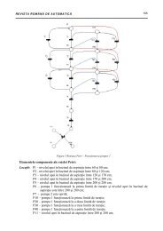
II. SYSTEM <strong>DE</strong>SCRIPTION<br />
A. System Purpose<br />
The project's aim is to elaborate technological<br />
support, necessary to environmental<br />
parameters acquisition in due time,<br />
evaluation, prognosis, follow evolutions and<br />
intelligent management of risk to flooding in<br />
an exposed area to hazard (2) .<br />
The purpose of the shown system is to<br />
contribute on the national effort of floods risk<br />
management by realization of an intelligent<br />
decisional support which will assess in real<br />
time the environmental parameters required<br />
by floods risk management in urban crowded<br />
places, on the basis of high technology like<br />
integrated mediums for historical data<br />
analysis, technology for modeling (1) and<br />
prognosis, GIS applications and mobile<br />
devices for operative activity coordination.<br />
The system will offer complex services.<br />
The system is meant to floods risk<br />
management and it permits online acquisition<br />
of environmental parameters; assures the<br />
introduction of data about this kind of<br />
hazards, into relational data base; uses a<br />
complex system of data analysis based on<br />
stochastic simulation, numerical method of<br />
evaluation and online analysis techniques of<br />
data storages for simulations, decisions and<br />
population information needful prognoses.<br />
The aim of the system is that of preventing and<br />
prealarming about the imminence of flooding<br />
occurrence in pilot zone. In this purpose, the<br />
system evaluates the real time evolution of the<br />
acquisitioned environmental parameters, on the<br />
basis of stochastic models and calculation<br />
procedure; realizes floodings prognosis that<br />
zone; generates the alerts to inform the decision<br />
factors; relieves the efficiency of consolidation<br />
measures; it informs and forms the staff from<br />
environmental domain.<br />
The project has the following scientific and<br />
technical goals:<br />
- building a real time data acquisition<br />
technological platform, analysis and<br />
decision taking - support of on-line<br />
monitorization of the parameters of the<br />
environment and the intelligent<br />
management of risk to floods;<br />
- implementation of analysis GIS support<br />
(hazard map and risk map of studied area);<br />
- implementation of services of risk<br />
management to floods;<br />
- operative information in due time the<br />
decision factors and population on static<br />
and mobile access devices;<br />
- the elaboration of prognosis solutions and<br />
evaluation of risk to flooding in<br />
determined areas and temporary intervals;<br />
- the evaluation of functioning of the<br />
hydromechanics installation operating<br />
in the dynamic regime to drain away<br />
large water flows;