

E book Field Guide.indd - Gold Country
E book Field Guide.indd - Gold Country
E book Field Guide.indd - Gold Country

Create successful ePaper yourself
Turn your PDF publications into a flip-book with our unique Google optimized e-Paper software.
SITE #090201<br />
GC1TWZ3<br />
GEOLOGICAL WONDERS<br />
Marble Canyon<br />
Written & Researched by Dominique Robillard<br />
Nearest Community:<br />
Parking:<br />
Geocache Location:<br />
Accuracy:<br />
Letterboxing Clues:<br />
SITE IDENTIFICATION<br />
UTM:<br />
Geocache altitude:<br />
Overall difficulty:<br />
Cache Creek, V0K 1H0<br />
N 50°50.329’<br />
W 121°42.048’<br />
N 50°50.034’<br />
W 121°41.865’<br />
10 meters<br />
Refer to letterboxing<br />
clues page<br />
East 0591702;<br />
North 5632161 10U<br />
823 m./2,699 ft.<br />
2<br />
2.5<br />
Terrain difficulty:<br />
(1=easiest; 5=hardest)<br />
Date Established: 1956<br />
Ownership: BC Provincial Park<br />
Access: • Highway<br />
• Year-round<br />
• Vehicle accessible<br />
• Detailed access<br />
infomation on next<br />
page.<br />
For more information or to report a problem<br />
with this site please contact:<br />
<strong>Gold</strong> <strong>Country</strong> Communities Society<br />
P.O. Box 933 Cache Creek, B.C. V0K 1H0<br />
Tel: 1-877-453-9467<br />
email: info@exploregoldcountry.com<br />
For more site pages go to:<br />
www.goldtrail.com or<br />
www.GeoTourismCanada.com<br />
Apply Sticker<br />
Here<br />
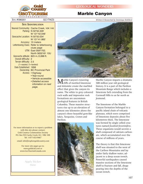
Marble Canyon’s towering<br />
cliffs of mottled limestone<br />
and dolomite create the marbled<br />
effect that gives the canyon its<br />
name. The white to grey coloured<br />
rock walls and impressive rock<br />
formations are uncommon<br />
geological features in British<br />
Columbia. These massive structures<br />
rise up to an elevation of<br />
almost one kilometre above the<br />
canyon’s three beautiful gem-like<br />
lakes, Turquoise, Crown and<br />
Pavilion.<br />
Marble Canyon imparts a dramatic<br />
500 million year old geological<br />
history. It is a part of the Pavilion<br />
Mountain Range which includes a<br />
limestone belt extending from the<br />
Cornwall Hills to as far north as<br />
Jesmond.<br />
The limestone of the Marble<br />
Canyon formation belonged to a<br />
pacific island chain of volcanic<br />
plateaus, which were comprised<br />
of limestone deposits about five<br />
kilometres thick. The limestone<br />
was formed by single celled creatures<br />
named fusulinid foraminifera.<br />
These organisms would secrete a<br />
shell composed of calcium carbonate,<br />
which accumulated over the<br />
course of millions of years.<br />
The theory is that this limestone<br />
shelf was situated to the west of<br />
the Cariboo Mountains and lay<br />
under fairly shallow water, adjacent<br />
to a deep ocean trench.<br />
Powerful earthquakes caused<br />
massive sections of the limestone<br />
shelf to fracture and fall, disappearing<br />
into the depths of the<br />
ocean trench.<br />
107


