

E book Field Guide.indd - Gold Country
E book Field Guide.indd - Gold Country
E book Field Guide.indd - Gold Country

Create successful ePaper yourself
Turn your PDF publications into a flip-book with our unique Google optimized e-Paper software.
SITE #120301<br />
GC1V20G<br />
VIEWS & VISTAS<br />
Stoyoma<br />
Written & Researched by Aline Lachapelle<br />
Nearest Community:<br />
Geocache Location:<br />
Accuracy:<br />
Letterboxing Clues:<br />
SITE IDENTIFICATION<br />
UTM:<br />
Merritt, V1K 1B8<br />
N 49°58.423’<br />
W 121°13.387’<br />
4 meters<br />
Refer to letterboxing<br />
clues page<br />
East 0627410;<br />
North 5537221 10U<br />
1,827 m./5,994 ft.<br />
1.5<br />
2 (road in 4)<br />
Geocache altitude:<br />
Overall difficulty:<br />
Terrain difficulty:<br />
(1=easiest; 5=hardest)<br />
n/a<br />
Crown Land<br />
Date Established:<br />
Ownership:<br />
Access:<br />
• Gravel Road<br />
• Seasonal<br />
• 4x4 Vehicle<br />
accessible<br />
• Detailed access<br />
information on next<br />
page.<br />
For more information or to report a problem<br />
with this site please contact:<br />
<strong>Gold</strong> <strong>Country</strong> Communities Society<br />
P.O. Box 933 Cache Creek, B.C. V0K 1H0<br />
Tel: 1-877-453-9467<br />
email: info@exploregoldcountry.com<br />
For more site pages go to:<br />
www.goldtrail.com or<br />
www.GeoTourismCanada.com<br />
Apply Sticker<br />
Here<br />
ne of the most rewarding<br />
Oadventures in the Merritt<br />
area is a trip up to Stoyoma<br />
Mountain. For many people, it<br />
begins by driving down into the<br />
Nicola Valley from Highway 97C<br />
and spotting a seemingly outof-place<br />
and often snowcapped<br />
peak. Once the descent into town<br />
is complete, the mountain is no<br />
longer visible. But if curiosity gets<br />
the best of you and you want to<br />
get an up-close look, then you<br />
will have to plan for a visit to the<br />
Cabin Lake Forest Recreation Site<br />
in the summer months of July,<br />
August and September.<br />
It is fascinating to watch the ecosystems<br />
change as the bunchgrass<br />
and Ponderosa pine dominated<br />
sites found along the Nicola River<br />
gradually shift to a more closed,<br />
Douglas-fir forest with scattered<br />
aspen and cottonwood trees<br />
along Spius Creek. At the higher<br />
elevation spruce and sub-alpine<br />
fir forests emerge as the road gets<br />
steeper and the elevation reaches<br />
up to 1,800 m near Cabin Lake,<br />
where the forest begins to<br />
transition to alpine.<br />
The last 3.5 km before the recreation<br />
site at Cabin Lake is not<br />
suitable for a low clearance, two<br />
wheel drive, camper-carrying or<br />
trailer-pulling vehicle, but can<br />
be driven in a 4x4 or on an ATV.<br />
Please note that other than driving<br />
on the Cabin Lake Road, there<br />
is no motor vehicle access allowed<br />
above 1,800 m in order to protect<br />
the sensitive alpine flora and<br />
fauna from the impacts of heavy<br />
ATV and dirt bike use.<br />
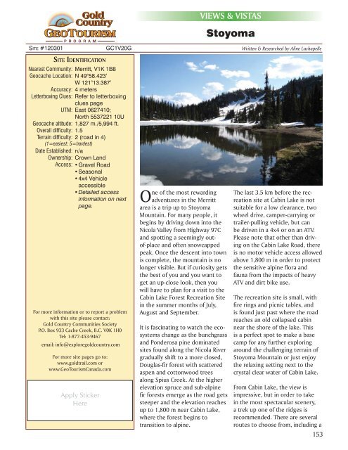
The recreation site is small, with<br />
fire rings and picnic tables, and<br />
is found just past where the road<br />
reaches an old collapsed cabin<br />
near the shore of the lake. This<br />
is a perfect spot to make a base<br />
camp for any further exploring<br />
around the challenging terrain of<br />
Stoyoma Mountain or just enjoy<br />
the relaxing setting next to the<br />
crystal clear water of Cabin Lake.<br />
From Cabin Lake, the view is<br />
impressive, but in order to take<br />
in the most spectacular scenery,<br />
a trek up one of the ridges is<br />
recommended. There are several<br />
routes to choose from, including a<br />
153


