

E book Field Guide.indd - Gold Country
E book Field Guide.indd - Gold Country
E book Field Guide.indd - Gold Country

Create successful ePaper yourself
Turn your PDF publications into a flip-book with our unique Google optimized e-Paper software.
Photo: Royal BC Museum, BC Archives, n o A-06160<br />
Further along from the park, past the second beach,<br />
one can again travel back several thousand years. On<br />
these great glacial rocks are the legends and drawings<br />
of the Salish people. These petroglyphs, prehistoric<br />
drawings on stone, are pictographs depicting the stories,<br />
values and culture of the inhabitants of the Nicola<br />
Valley thousands of years past.<br />
Monck Park is rich in geological history, an archaeological<br />
gold mine and a scenic glory, bearing a kingdom of<br />
wildlife. With Nicola Lake it is a picture perfect landscape,<br />
a shining jewel, in the heart of <strong>Gold</strong> <strong>Country</strong>.<br />
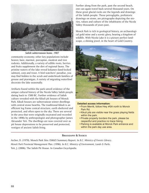
Salish subterranean home, 1907<br />
community economy; other key populations include<br />
beaver, hare, marmot, porcupine, muskrat and tree<br />
rodents. Additionally, a variety of edible roots, berries<br />
and fruits supplement the diet of regional fauna. The<br />
pristine waters of the lake reveal kokanee (land-locked<br />
salmon), carp and trout. A bird watchers’ paradise, you<br />
may find hidden in the scrub and underbrush families of<br />
grouse and ptarmigan. A variety of migrating waterfowl<br />
decorate the lake seasonally.<br />
Artifacts found within the park unveil evidence of the<br />
unique cultural history of the Nicola Valley Salish people<br />
dating back to 1500 BC. Further evidence of Salish<br />
culture revealed with the Kikuli pit houses of Monck<br />
Park. Kikuli houses are subterranean winter dwellings<br />
with central stone hearths. The traditional Kikuli is an<br />
efficient log frame conical structure, earth sheltered and<br />
protected, and often open to the sky. There are several<br />
in the area that were originally excavated and recorded<br />
in the 1890s by anthropologist and photographer James<br />
Alexander Teit. The dwellings are now covered over as<br />
pit house depressions to be preserved and protected,<br />
vestiges of ancient Salish living.<br />
Detailed access information:<br />
• From Merritt, follow Hwy #5A north to Monck<br />
Park Rd.<br />
• Kikuli pits are visible near the grass playing fields<br />
within the park.<br />
• Private property borders the park, please be<br />
respectful and practice no trace hiking.<br />
• Parking is available at Monck Park entrance and<br />
within the park day use area.<br />
BIBLIOGRAPHY & SOURCES<br />
Archer, D. (1970). Monck Park Site: EbRd3 Summary Report. In B.C. Ministry of Forests Library.<br />
Monck Park Provincial Management Plan. (1996). In B.C. Ministry of Environment, Lands & Parks.<br />
Teit, J. (2006). The Salish Pit House. In Canadian Encyclopedia.<br />
88


