

E book Field Guide.indd - Gold Country
E book Field Guide.indd - Gold Country
E book Field Guide.indd - Gold Country

You also want an ePaper? Increase the reach of your titles
YUMPU automatically turns print PDFs into web optimized ePapers that Google loves.
SITE #060201<br />
GC1TKWQ<br />
GEOLOGICAL WONDERS<br />
<strong>Gold</strong>pan Provincial Park<br />
Written & Researched by Peter McArthur<br />
Nearest Community:<br />
Location/Parking:<br />
Geocache Location:<br />
Accuracy:<br />
Letterboxing Clues:<br />
SITE IDENTIFICATION<br />
UTM:<br />
Geocache altitude:<br />
Overall difficulty:<br />
Lytton, V0K 1Z0<br />
N 50°20.991’<br />
W 121°23.371’<br />
N 50°20.743’<br />
W 121°23.374’<br />
4 meters<br />
Refer to letterboxing<br />
clues page<br />
East 0614582;<br />
North 5578310 10U<br />
214 m./701 ft.<br />
2<br />
2<br />
Terrain difficulty:<br />
(1=easiest; 5=hardest)<br />
Date Established: 1956<br />
Ownership: BC Provincial Park<br />
Access: • Highway<br />
• Year-round<br />
• Vehicle accessible<br />
• Located 10 km south<br />
of Spences Bridge<br />
on Hwy #1.<br />
• Located 28 km north<br />
of Lytton on Hwy #1.<br />
Note: Fishermen must<br />
check regulations for<br />
closures.<br />
For more information or to report a problem<br />
with this site please contact:<br />
<strong>Gold</strong> <strong>Country</strong> Communities Society<br />
P.O. Box 933 Cache Creek, B.C. V0K 1H0<br />
Tel: 1-877-453-9467<br />
email: info@exploregoldcountry.com<br />
For more site pages go to:<br />
www.goldtrail.com or<br />
www.GeoTourismCanada.com<br />
Apply Sticker<br />
Here<br />
<strong>Gold</strong>pan Provincial Park hosts<br />
14 campsites and a few day<br />
use picnic tables on 5 hectares,<br />
tucked between the Thompson<br />
River and the Trans Canada<br />
Highway. Scenery, semi-precious<br />
gems, wildlife, fishing, train<br />
watching, history and more make<br />
this park quite charming!<br />
The park road is part of the original<br />
Cariboo Wagon Road. Before<br />
the park was created, the <strong>Gold</strong>pan<br />
area was commonly used as a<br />
resting area and camping location.<br />
The Thompson River, through this<br />
stretch, is famous for its steelhead<br />
fishery and the nearby community<br />
of Spences Bridge contains several<br />
historic buildings over 100 years<br />
old. The Nlaka’pamux are the<br />
indigenous people of the area<br />
and you may discover arrowheads<br />
of chert and agate, remnant<br />
evidence of their traditional<br />
lifestyle. Most commonly found<br />
are small flakes of chert, showing<br />
where stone implements were<br />
made. Chert is an exceptionally<br />
hard, sedimentary rock that may<br />
contain fossils.<br />
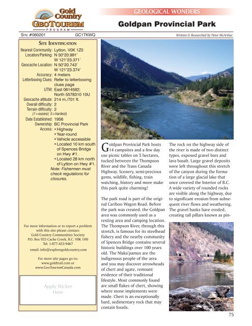
The rock on the highway side of<br />
the river is made of two distinct<br />
types, exposed gravel bars and<br />
lava basalt. Large gravel deposits<br />
were left throughout this stretch<br />
of the canyon during the formation<br />
of a large glacial lake that<br />
once covered the Interior of B.C.<br />
A wide variety of rounded rocks<br />
are visible along the highway, due<br />
to significant erosion from subsequent<br />
river flows and weathering.<br />
The gravel banks have eroded,<br />
creating tall pillars known as pin-<br />
75


