

E book Field Guide.indd - Gold Country
E book Field Guide.indd - Gold Country
E book Field Guide.indd - Gold Country

Create successful ePaper yourself
Turn your PDF publications into a flip-book with our unique Google optimized e-Paper software.
SITE #120102<br />
GC1V1YV<br />
PIONEERS & EARLY SETTLERS<br />
Brookmere<br />
Written & Researched by Angela Wynton<br />
Nearest Community:<br />
Location:<br />
Geocache Location:<br />
Accuracy:<br />
Letterboxing Clues:<br />
SITE IDENTIFICATION<br />
UTM:<br />
Merritt, V1K 1B8<br />
N 49°49.066’<br />
W 120°52.343’<br />
N 49°48.964’<br />
W 120°51.947’<br />
7 meters<br />
Refer to letterboxing<br />
clues page<br />
East 0653529;<br />
North 5520365 10U<br />
986 m./3,235 ft.<br />
1<br />
1<br />
Geocache altitude:<br />
Overall difficulty:<br />
Terrain difficulty:<br />
(1=easiest; 5=hardest)<br />
c 1909<br />
Crown Land<br />
Date Established:<br />
Ownership:<br />
Access:<br />
• Gravel Road<br />
• Year-round<br />
• Vehicle accessible<br />
• Take Coldwater exit<br />
256 off Hwy #5<br />
11 km to Brookmere.<br />
• Please respect the<br />
privacy of local<br />
residents.<br />
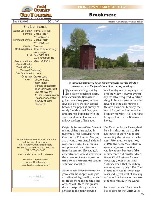
The last remaining Kettle Valley Railway watertower still stands in<br />
Brookmere, near the foundations of the railway buildings.<br />
High above the Voght Valley<br />
is a barely populated sleepy<br />
little community. Brookmere’s<br />
golden years long past, its heydays<br />
and glory are now nestled<br />
between the pages of history. At<br />
nearly four thousand feet, quiet<br />
Brookmere is brimming with the<br />
stories and tales of miners and<br />
railway workers of long ago.<br />
small mining towns popping up all<br />
over the valley. However, eventually<br />
the labour required to extract<br />
the gold became greater than the<br />
reward and the gold mining in<br />
the area dwindled. Recently, the<br />
search for gold and minerals has<br />
been revived with 17,114 hectares<br />
being explored in the Brookmere<br />
Project.<br />
For more information or to report a problem<br />
with this site please contact:<br />
<strong>Gold</strong> <strong>Country</strong> Communities Society<br />
P.O. Box 933 Cache Creek, B.C. V0K 1H0<br />
Tel: 1-877-453-9467<br />
email: info@exploregoldcountry.com<br />
For more site pages go to:<br />
www.goldtrail.com or<br />
www.GeoTourismCanada.com<br />
Apply Sticker<br />
Here<br />
Originally known as Otter Summit,<br />
mining claims were staked in<br />
numerous areas following Voght<br />
Creek to the Coldwater River, up<br />
and around the mountainside and<br />
numerous creeks. Small mining<br />
was prevalent in all directions<br />
from the summit. Elevated gold<br />
concentrations were discovered in<br />
the stream sediments, as well as<br />
there being multi-element stream<br />
sediment anomalies.<br />
As the Nicola Valley continued to<br />
grow with the copper, coal, gold<br />
and silver mining, so did the need<br />
for transporting the minerals and<br />
ores. As well, there was greater<br />
demand to provide goods and<br />
services to the many growing<br />
The Canadian Pacific Railway had<br />
built its railway tracks into the<br />
Kootneys but there was no line<br />
connecting the railway to the far<br />
west. After much competition,<br />
in 1910 the Kettle Valley Railway<br />
system began construction.<br />
And it was only because of the<br />
perseverance and constant direction<br />
of Chief Engineer Andrew<br />
McCullogh, lover of all things<br />
Shakespearean, that the railway<br />
was completed by July 1916. The<br />
construction was met with high<br />
costs and a great deal of hardship<br />
and would be known as the most<br />
expensive railway in the world.<br />
But it was the need for a branch<br />
line to connect the Kettle Valley<br />
145


