

E book Field Guide.indd - Gold Country
E book Field Guide.indd - Gold Country
E book Field Guide.indd - Gold Country

Create successful ePaper yourself
Turn your PDF publications into a flip-book with our unique Google optimized e-Paper software.
SITE #040303<br />
GC1V1V4<br />
VIEWS & VISTAS<br />
Red Rock<br />
Written & Researched by Wendy Fraser<br />
Nearest Community:<br />
Parking:<br />
Geocache Location:<br />
Accuracy:<br />
Letterboxing Clues:<br />
SITE IDENTIFICATION<br />
UTM:<br />
Geocache altitude:<br />
Overall difficulty:<br />
Terrain difficulty:<br />
(1=easiest; 5=hardest)<br />
Lillooet, V0K 1V0<br />
N 50°41.534’<br />
W 121°56.630’<br />
N 50°42.112’<br />
W 121°57.217’<br />
5 meters<br />
Refer to letterboxing<br />
clues page<br />
East 0573893;<br />
North 5617195 10U<br />
828 m./2,717 ft.<br />
1.5<br />
3.5<br />
Date Established: n/a<br />
Ownership: Crown Land &<br />
First Nations<br />
Access: • Public Road<br />
• Seasonal<br />
• Hiking Required<br />
(3.5 km)<br />
• Detailed access<br />
information on next<br />
page.<br />
For more information or to report a problem<br />
with this site please contact:<br />
<strong>Gold</strong> <strong>Country</strong> Communities Society<br />
P.O. Box 933 Cache Creek, B.C. V0K 1H0<br />
Tel: 1-877-453-9467<br />
email: info@exploregoldcountry.com<br />
For more site pages go to:<br />
www.goldtrail.com or<br />
www.GeoTourismCanada.com<br />
Apply Sticker<br />
Here<br />
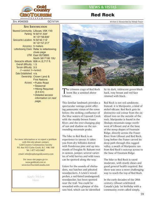
The crimson crags of Red Rock<br />
loom like a sentinel above<br />
Lillooet.<br />
This familiar landmark provides a<br />
spectacular vantage point offering<br />
panoramic vistas of the town<br />
below; the striking confluence of<br />
the blue waters of Cayoosh Creek<br />
with the muddy brown Fraser<br />
River; and the ever-changing play<br />
of sun and shadow on the surrounding<br />
mountain peaks.<br />
The hike to Red Rock is an<br />
experience to savour. It takes<br />
you from dry hillsides dotted<br />
with Ponderosa pine and up into<br />
stands of Douglas fir. Balsam root<br />
in season, juniper, several varieties<br />
of wild berries and wild roses<br />
can be spotted along the way.<br />
Listen for the sounds of chickadees,<br />
nut hatches and pileated<br />
woodpeckers. A Lewis’s woodpecker,<br />
a red-listed (endangered)<br />
woodpecker, has been spotted<br />
near the trail. You could be<br />
rewarded with a glimpse of this<br />
rare bird, which can be identified<br />
by its dark, iridescent green-black<br />
back, rosy breast and red face<br />
rimmed with black.<br />
Red Rock is not red sandstone.<br />
Instead, it is Mariposite, a kind of<br />
nickel silicate. Red Rock gets its<br />
distinctive red colour from the oxidized<br />
iron on the outside of the<br />
rock. Mariposite is found in the<br />
Shulaps mountain range northwest<br />
of Lillooet and at the base<br />
of the steep slopes of Fountain<br />
Ridge, directly across the Fraser<br />
River from Lillooet and Red Rock.<br />
Long before the Fraser carved its<br />
deep path through this rugged<br />
valley, a swath of Mariposite ran<br />
from Red Rock’s outcrop across to<br />
the base of Fountain Ridge.<br />
The hike to Red Rock is rated<br />
moderate, with sturdy shoes and<br />
good general health required. But<br />
there was once a more challenging<br />
way to reach the top of Red Rock.<br />
In the early decades of the 20th<br />
century, Lillooet celebrated<br />
Canada’s July 1st birthday with a<br />
community event called simply,<br />
59


