

E book Field Guide.indd - Gold Country
E book Field Guide.indd - Gold Country
E book Field Guide.indd - Gold Country

You also want an ePaper? Increase the reach of your titles
YUMPU automatically turns print PDFs into web optimized ePapers that Google loves.
SITE #070301<br />
GC1TTW0<br />
VIEWS & VISTAS<br />
Monck Provincial Park<br />
Written & Researched by Angela Wynton<br />
Nearest Community:<br />
Location/Parking:<br />
Geocache Location:<br />
Accuracy:<br />
Letterboxing Clues:<br />
SITE IDENTIFICATION<br />
UTM:<br />
Geocache altitude:<br />
Overall difficulty:<br />
Merritt, V1K 1B8<br />
N 50°10.585’<br />
W 120°32.271’<br />
N 50°10.614’<br />
W 120°32.414’<br />
6 meters<br />
Refer to letterboxing<br />
clues page<br />
East 0675627;<br />
North 5561197 10U<br />
730 m./2,395 ft.<br />
1.5<br />
2.5<br />
Terrain difficulty:<br />
(1=easiest; 5=hardest)<br />
Date Established: 1951<br />
Ownership: BC Provincial Park<br />
Access: • Public Road<br />
• Year-round<br />
• Vehicle accessible<br />
• Detailed access<br />
information on next<br />
page.<br />
For more information or to report a problem<br />
with this site please contact:<br />
<strong>Gold</strong> <strong>Country</strong> Communities Society<br />
P.O. Box 933 Cache Creek, B.C. V0K 1H0<br />
Tel: 1-877-453-9467<br />
email: info@exploregoldcountry.com<br />
For more site pages go to:<br />
www.goldtrail.com or<br />
www.GeoTourismCanada.com<br />
Apply Sticker<br />
Here<br />
onck Park offers an extraor-<br />
combination of First Mdinary<br />
Nations history and biodiversity.<br />
Amid the ponderosa pine, black<br />
cottonwood, douglas fir, tule and<br />
cattail, are remarkable Kikuli depressions<br />
and native petroglyphs.<br />
Originally part of one of the<br />
largest ranches of the last century,<br />
the land was bequeathed as a<br />
park and protected environment<br />
in 1919 by Charles Sydney ‘Major’<br />
<strong>Gold</strong>man and named after his son,<br />
Commander Victor Robert Penryn<br />
Monck of the Royal Navy. The<br />
provincial park was established in<br />
1951.<br />
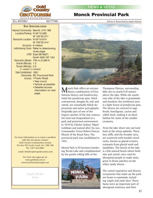
Monck Park is 92 hectares bordering<br />
Nicola Lake and complimented<br />
by the gentle rolling hills of the<br />
Thompson Plateau, surrounding<br />
hills rise to nearly 610 meters<br />
above the lake. While the southeast<br />
side of the lake is grasslands<br />
and meadow, the northwest area<br />
is a light forest of ponderosa pine.<br />
The shores are covered in sage<br />
brush, bunchgrass, cactus and<br />
rabbit bush, making it an ideal<br />
habitat for some of the smaller<br />
creatures.<br />
From the lake shore one can look<br />
back at the steep uplands. These<br />
lava cliffs, and the broader area,<br />
are scattered with boulder-sized<br />
rocks, known as glacial erratics,<br />
remnants from glacial wash and<br />
landslides. The bench of the lake<br />
is a flat natural beach where both<br />
tule and cattail, once used by<br />
aboriginal people to make mats,<br />
grow in dense patches on the<br />
white sandy shores.<br />
The varied vegetation and diverse<br />
ecosystems that make up the park<br />
are home to mammals, including<br />
wapiti and mule deer. These<br />
fauna were an important part of<br />
aboriginal existence and their<br />
87


