

Weeki Wachee River System Recommended Minimum Flows and ...
Weeki Wachee River System Recommended Minimum Flows and ...
Weeki Wachee River System Recommended Minimum Flows and ...

Create successful ePaper yourself
Turn your PDF publications into a flip-book with our unique Google optimized e-Paper software.
Lecanto 1 & 2<br />
#S<br />
Well Site Description<br />
#S Unconfined UFAS<br />
#S TR20-2<br />
#³ Semi-confined UFAS<br />
#Y Perched Water Table<br />
with confined UFAS<br />
Note: * Surficial S<strong>and</strong><br />
Unsaturated<br />
Engle Park<br />
#S<br />
Unconfined<br />
UFAS<br />
2W<br />
#S<br />
#³<br />
SR52W<br />
#Y<br />
Spring Hill<br />
98*<br />
#S<br />
2NW<br />
#S<br />
1N<br />
1NW #S #S<br />
#³ 1SW<br />
Locally Perched<br />
Water Table<br />
<strong>Weeki</strong> 11<br />
#Y<br />
2NE<br />
#S<br />
3E<br />
#³<br />
BR-2 #Y<br />
Brooksville<br />
East<br />
#Y<br />
#Y<br />
San Antonio<br />
Park<br />
99X* #S<br />
BR-3<br />
#Y<br />
LB-12<br />
#³<br />
#³<br />
Mascotte<br />
#Y<br />
SR 577<br />
Semi-confined<br />
UFAS<br />
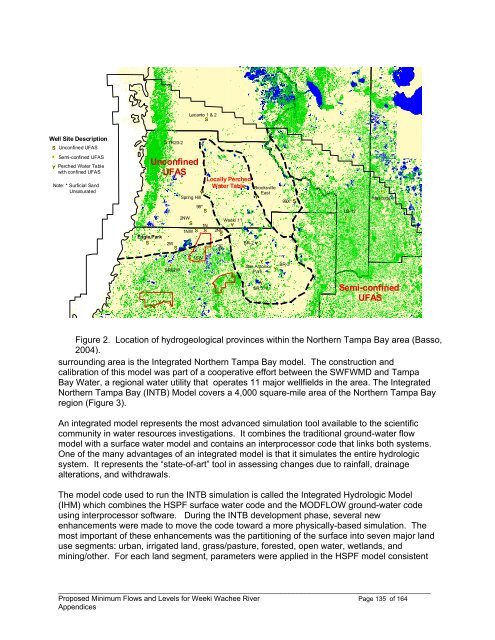
Figure 2. Location of hydrogeological provinces within the Northern Tampa Bay area (Basso,<br />
2004).<br />
surrounding area is the Integrated Northern Tampa Bay model. The construction <strong>and</strong><br />
calibration of this model was part of a cooperative effort between the SWFWMD <strong>and</strong> Tampa<br />
Bay Water, a regional water utility that operates 11 major wellfields in the area. The Integrated<br />
Northern Tampa Bay (INTB) Model covers a 4,000 square-mile area of the Northern Tampa Bay<br />
region (Figure 3).<br />
An integrated model represents the most advanced simulation tool available to the scientific<br />
community in water resources investigations. It combines the traditional ground-water flow<br />
model with a surface water model <strong>and</strong> contains an interprocessor code that links both systems.<br />
One of the many advantages of an integrated model is that it simulates the entire hydrologic<br />
system. It represents the “state-of-art” tool in assessing changes due to rainfall, drainage<br />
alterations, <strong>and</strong> withdrawals.<br />
The model code used to run the INTB simulation is called the Integrated Hydrologic Model<br />
(IHM) which combines the HSPF surface water code <strong>and</strong> the MODFLOW ground-water code<br />
using interprocessor software. During the INTB development phase, several new<br />
enhancements were made to move the code toward a more physically-based simulation. The<br />
most important of these enhancements was the partitioning of the surface into seven major l<strong>and</strong><br />
use segments: urban, irrigated l<strong>and</strong>, grass/pasture, forested, open water, wetl<strong>and</strong>s, <strong>and</strong><br />
mining/other. For each l<strong>and</strong> segment, parameters were applied in the HSPF model consistent<br />
____________________________________________________________________________________________<br />
Proposed <strong>Minimum</strong> <strong>Flows</strong> <strong>and</strong> Levels for <strong>Weeki</strong> <strong>Wachee</strong> <strong>River</strong> Page 135 of 164<br />
Appendices


