

Weeki Wachee River System Recommended Minimum Flows and ...
Weeki Wachee River System Recommended Minimum Flows and ...
Weeki Wachee River System Recommended Minimum Flows and ...

You also want an ePaper? Increase the reach of your titles
YUMPU automatically turns print PDFs into web optimized ePapers that Google loves.
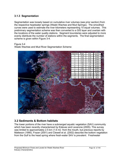
3.1.3 Segmentation<br />
Segmentation was loosely based on cumulative river volumes (see prior section) from<br />
the respective headwater springs (<strong>Weeki</strong> <strong>Wachee</strong> <strong>and</strong> Mud Springs). The smoothed<br />
curves were used to estimate the river kilometers representing 10 equal volumes. This<br />
preliminary segmentation scheme was then converted to a GIS layer <strong>and</strong> overlain with<br />
the locations of the water quality stations. Segment boundaries were adjusted to more<br />
evenly distribute the number of stations within the segments. The final segmentation<br />
scheme is given within Figure 3-4.<br />
Figure 3-4<br />
<strong>Weeki</strong> <strong>Wachee</strong> <strong>and</strong> Mud <strong>River</strong> Segmentation Scheme<br />
0<br />
1 2 3 4<br />
5<br />
10<br />
6<br />
11<br />
12<br />
7<br />
Segment Begin End <strong>System</strong><br />
0 -5.20 0.00 <strong>Weeki</strong><br />
1 0.00 0.35 <strong>Weeki</strong><br />
2 0.35 0.53 <strong>Weeki</strong><br />
3 0.35 0.82 <strong>Weeki</strong><br />
4 0.82 1.25 <strong>Weeki</strong><br />
5 1.25 1.91 <strong>Weeki</strong><br />
6 1.91 2.92 <strong>Weeki</strong><br />
7 2.92 4.46 <strong>Weeki</strong><br />
8 4.46 6.81 <strong>Weeki</strong><br />
9 6.81 >6.81 <strong>Weeki</strong><br />
10 1.42 2.28 Mud<br />
11 2.28 3.15 Mud<br />
12 3.15 >3.15 Mud<br />
8<br />
9<br />
3.2 Sediments & Bottom habitats<br />
The lower portions of the river have a submerged aquatic vegetation (SAV) community<br />
which has been recently characterized by Estevez <strong>and</strong> Leverone (2005). This survey<br />
was limited to approximately 2.5 km (1.6 mi) from the mouth, but previous reports by<br />
Matteson (1995), Frazer (2001) <strong>and</strong> Clewell et al. (2002) describe the bottom vegetation<br />
from the Gulf to the head spring where fresh-water SAV is prevalent. Freshwater<br />
____________________________________________________________________________________________<br />
Proposed <strong>Minimum</strong> <strong>Flows</strong> <strong>and</strong> Levels for <strong>Weeki</strong> <strong>Wachee</strong> <strong>River</strong> Page 42 of 164<br />
Estuary Characteristics


