

Weeki Wachee River System Recommended Minimum Flows and ...
Weeki Wachee River System Recommended Minimum Flows and ...
Weeki Wachee River System Recommended Minimum Flows and ...

Create successful ePaper yourself
Turn your PDF publications into a flip-book with our unique Google optimized e-Paper software.
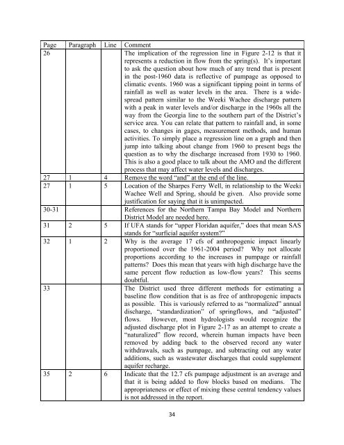
Page Paragraph Line Comment<br />
26 The implication of the regression line in Figure 2-12 is that it<br />
represents a reduction in flow from the spring(s). It’s important<br />
to ask the question about how much of any trend that is present<br />
in the post-1960 data is reflective of pumpage as opposed to<br />
climatic events. 1960 was a significant tipping point in terms of<br />
rainfall as well as water levels in the area. There is a widespread<br />
pattern similar to the <strong>Weeki</strong> <strong>Wachee</strong> discharge pattern<br />
with a peak in water levels <strong>and</strong>/or discharge in the 1960s all the<br />
way from the Georgia line to the southern part of the District’s<br />
service area. You can relate that pattern to rainfall <strong>and</strong>, in some<br />
cases, to changes in gages, measurement methods, <strong>and</strong> human<br />
activities. To simply place a regression line on a graph <strong>and</strong> then<br />
jump into talking about change from 1960 to present begs the<br />
question as to why the discharge increased from 1930 to 1960.<br />
This is also a good place to talk about the AMO <strong>and</strong> the different<br />
process that may affect water levels <strong>and</strong> discharges.<br />
27 1 4 Remove the word “<strong>and</strong>” at the end of the line.<br />
27 1 5 Location of the Sharpes Ferry Well, in relationship to the <strong>Weeki</strong><br />
<strong>Wachee</strong> Well <strong>and</strong> Spring, should be given. Also provide some<br />
justification for saying that it is unimpacted.<br />
30-31 References for the Northern Tampa Bay Model <strong>and</strong> Northern<br />
District Model are needed here.<br />
31 2 5 If UFA st<strong>and</strong>s for “upper Floridan aquifer,” does that mean SAS<br />
st<strong>and</strong>s for “surficial aquifer system?”<br />
32 1 2 Why is the average 17 cfs of anthropogenic impact linearly<br />
proportioned over the 1961-2004 period? Why not allocate<br />
proportions according to the increases in pumpage or rainfall<br />
patterns? Does this mean that years with high discharge have the<br />
same percent flow reduction as low-flow years? This seems<br />
doubtful.<br />
33 The District used three different methods for estimating a<br />
baseline flow condition that is as free of anthropogenic impacts<br />
as possible. This is variously referred to as “normalized” annual<br />
discharge, “st<strong>and</strong>ardization” of springflows, <strong>and</strong> “adjusted”<br />
flows. However, most hydrologists would recognize the<br />
adjusted discharge plot in Figure 2-17 as an attempt to create a<br />
“naturalized” flow record, wherein human impacts have been<br />
removed by adding back to the observed record any water<br />
withdrawals, such as pumpage, <strong>and</strong> subtracting out any water<br />
additions, such as wastewater discharges that could supplement<br />
aquifer recharge.<br />
35 2 6 Indicate that the 12.7 cfs pumpage adjustment is an average <strong>and</strong><br />
that it is being added to flow blocks based on medians. The<br />
appropriateness or effect of mixing these central tendency values<br />
is not addressed in the report.<br />
34


