

Weeki Wachee River System Recommended Minimum Flows and ...
Weeki Wachee River System Recommended Minimum Flows and ...
Weeki Wachee River System Recommended Minimum Flows and ...

Create successful ePaper yourself
Turn your PDF publications into a flip-book with our unique Google optimized e-Paper software.
#<br />
#<br />
#<br />
Surface waters in this stretch of the coast are also affected by several forcing functions<br />
(Wolfe 1990) not exerted on inl<strong>and</strong> waters. Winds play a major role in setting up<br />
circulation on the shallow coast, resulting in a net long-term movement of coastal waters<br />
north <strong>and</strong> west during late spring, summer <strong>and</strong> early fall. In contrast during the winter<br />
months a net circulation to the south <strong>and</strong> east results from the winds associated with<br />
passage of cold fronts. Short-term convective on-shore /off-shore forcing functions<br />
characterize the summer months.<br />
3.1.2 Area / Volume<br />
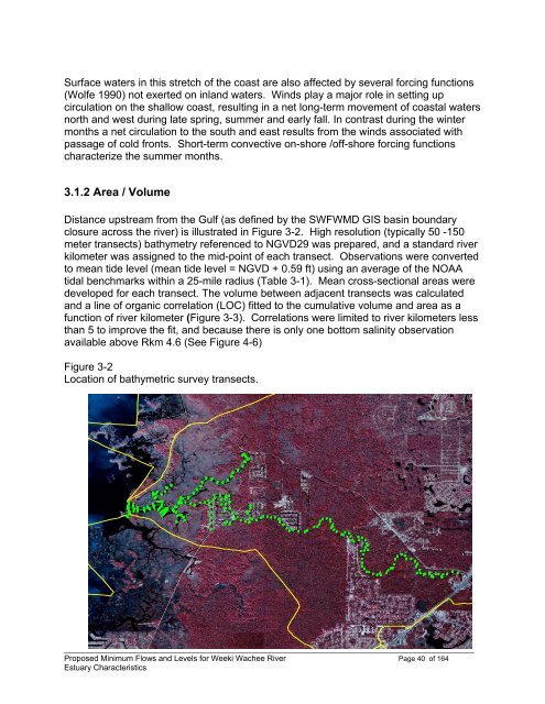
Distance upstream from the Gulf (as defined by the SWFWMD GIS basin boundary<br />
closure across the river) is illustrated in Figure 3-2. High resolution (typically 50 -150<br />
meter transects) bathymetry referenced to NGVD29 was prepared, <strong>and</strong> a st<strong>and</strong>ard river<br />
kilometer was assigned to the mid-point of each transect. Observations were converted<br />
to mean tide level (mean tide level = NGVD + 0.59 ft) using an average of the NOAA<br />
tidal benchmarks within a 25-mile radius (Table 3-1). Mean cross-sectional areas were<br />
developed for each transect. The volume between adjacent transects was calculated<br />
<strong>and</strong> a line of organic correlation (LOC) fitted to the cumulative volume <strong>and</strong> area as a<br />
function of river kilometer (Figure 3-3). Correlations were limited to river kilometers less<br />
than 5 to improve the fit, <strong>and</strong> because there is only one bottom salinity observation<br />
available above Rkm 4.6 (See Figure 4-6)<br />
Figure 3-2<br />
Location of bathymetric survey transects.<br />
#<br />
#<br />
#<br />
#<br />
#<br />
#<br />
#<br />
#<br />
#<br />
#<br />
# #<br />
##<br />
#<br />
#<br />
#<br />
#<br />
#<br />
#<br />
#<br />
#<br />
#<br />
#<br />
#<br />
#<br />
#<br />
# #<br />
#<br />
#<br />
#<br />
#<br />
#<br />
#<br />
#<br />
#<br />
#<br />
#<br />
#<br />
#<br />
#<br />
#<br />
# #<br />
#<br />
#<br />
#<br />
#<br />
# #<br />
#<br />
#<br />
#<br />
#<br />
#<br />
#<br />
#<br />
#<br />
#<br />
#<br />
#<br />
# #<br />
#<br />
#<br />
#<br />
#<br />
#<br />
#<br />
#<br />
# #<br />
#<br />
#<br />
#<br />
#<br />
#<br />
#<br />
#<br />
#<br />
# # # # # #<br />
# # # #<br />
# #<br />
#<br />
#<br />
#<br />
# #<br />
# # #<br />
# # # #<br />
#<br />
#<br />
# ##<br />
# #<br />
#<br />
#<br />
#<br />
# # #<br />
#<br />
# #<br />
# #<br />
# #<br />
#<br />
#<br />
# ##<br />
#<br />
#<br />
#<br />
#<br />
#<br />
#<br />
# # # # # #<br />
# # #<br />
#<br />
#<br />
## # ## #<br />
#<br />
#<br />
#<br />
#<br />
# # # #<br />
##<br />
# #<br />
# # #<br />
#<br />
#<br />
____________________________________________________________________________________________<br />
Proposed <strong>Minimum</strong> <strong>Flows</strong> <strong>and</strong> Levels for <strong>Weeki</strong> <strong>Wachee</strong> <strong>River</strong> Page 40 of 164<br />
Estuary Characteristics


