

Watershed Management Plan - Mason County
Watershed Management Plan - Mason County
Watershed Management Plan - Mason County

You also want an ePaper? Increase the reach of your titles
YUMPU automatically turns print PDFs into web optimized ePapers that Google loves.
Sub-basin Summaries<br />
Appendix<br />
A<br />
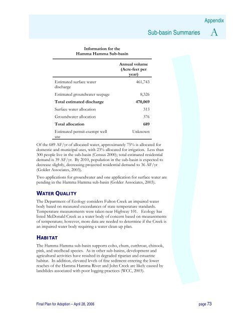
Estimated surface water<br />
discharge<br />
Information for the<br />
Hamma Hamma Sub-basin<br />
Annual volume<br />
(Acre-feet per<br />
year)<br />
461,743<br />
Estimated groundwater seepage 8,326<br />
Total estimated discharge 470,069<br />
Surface water allocation 313<br />
Groundwater allocation 376<br />
Total allocation 689<br />
Estimated permit-exempt well<br />
Unknown<br />
use<br />
Of the 689 AF/yr of allocated water, approximately 75% is allocated for<br />
domestic and municipal uses, with 23% allocated for irrigation. Less than<br />
300 people live in the sub-basin (Census 2000); total estimated residential<br />
demand is 39 AF/yr. By 2010, population in the sub-basin is expected to<br />
decrease slightly, decreasing projected residential demand to 36 AF/yr<br />
(Golder Associates, 2003).<br />
Two applications for groundwater and one application for surface water are<br />
pending in the Hamma Hamma sub-basin (Golder Associates, 2003).<br />
WATER QUALITY<br />
The Department of Ecology considers Fulton Creek an impaired water<br />
body based on measured exceedances of state temperature standards.<br />
Temperature measurements were taken near Highway 101. Ecology has<br />
listed McDonald Creek as a water body of concern based on measurements<br />
of temperature; however, more data are needed to determine if the Creek is<br />
an impaired water body requiring a water clean-up plan.<br />
HABITAT<br />
The Hamma Hamma sub-basin supports coho, chum, cutthroat, chinook,<br />
pink, and steelhead species. As in other sub-basins, development and<br />
agricultural activities have resulted in degraded riparian and estuarine<br />
habitat. In addition, elevated levels of fine sediment entering the lower<br />
reaches of the Hamma Hamma River and John Creek are likely caused by<br />
landslides associated with poor logging practices (WCC, 2003).<br />
Final <strong>Plan</strong> for Adoption – April 28, 2006 page 73


