IMProVe 2011 - Proceedings
IMProVe 2011 - Proceedings
IMProVe 2011 - Proceedings

You also want an ePaper? Increase the reach of your titles
YUMPU automatically turns print PDFs into web optimized ePapers that Google loves.
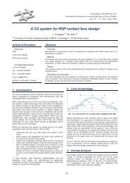
Surveying, Mapping and GIS Techniques<br />
This work is framed within a reuse project of traditional underground cellars.<br />
Underground wine cellars are singular elements of the architectonic and cultural Spanish<br />
heritage. The goal is to have for the reuse and intervention analysis valid documents<br />
which represent the reality of the object being studied as closely as possible,<br />
understanding the level of abstraction of the graphic representation.<br />
Method:<br />
To establish the proposed reuse and intervention measures the mapping of the cellars is<br />
necessary. First of all it was necessary to clean and recondition the cellars. Then a<br />
topographical survey of the cellars was carried out. Given the irregular geometry and<br />
characteristics of the constructions under study, the conducted survey data have required<br />
a graphic interpretation, completing these data with the information obtained in<br />
subsequent visits to the cellars.<br />
Result:<br />
The result plans are as complete as possible to understand the shape, interior volume and<br />
state of the cellars: location, framework, details and singular points, pathologies, cross<br />
sections, longitudinal sections, images, necessary intervention measures and reuse<br />
proposal.<br />
Discussion & Conclusion:<br />
We propose a methodology for conducting the mapping of underground constructions,<br />
through a topographic survey and graphic interpretation of the results. The result plans<br />
offers a geometric definition of the wine cellars, being the support for the analysis and<br />
diagnosis of the conservation state. The plans are instrument to know with acceptable<br />
error the real surface, geometry and length of the cellars. This methodology based on<br />
total stations could be a reference for similar studies.<br />
Keywords: topographic survey, graphic interpretation, cellar, underground<br />
Corresponding Author: Fernando R. Mazarrón<br />
Tel.:+34913365767<br />
Fax.:+34913363688<br />
e-mail: f.ruiz@upm.es<br />
Address:E.T.S.I.Agrónomos. Departamento de Construcción y Vías Rurales. Avenida Complutense<br />
s/n. 28040 Madrid.<br />
June 15 th – 17 th , <strong>2011</strong>, Venice, Italy<br />
144<br />
<strong>IMProVe</strong> <strong>2011</strong> - <strong>Proceedings</strong>