Where am I? Sensors and Methods for Mobile Robot Positioning
Where am I? Sensors and Methods for Mobile Robot Positioning
Where am I? Sensors and Methods for Mobile Robot Positioning

Create successful ePaper yourself
Turn your PDF publications into a flip-book with our unique Google optimized e-Paper software.
Chapter 3: Active Beacons 75<br />
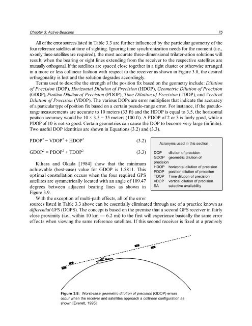
All of the error sources listed in Table 3.3 are further influenced by the particular geometry of the<br />
four reference satellites at time of sighting. Ignoring time synchronization needs <strong>for</strong> the moment (i.e.,<br />
so only three satellites are required), the most accurate three-dimensional trilater-ation solutions will<br />
result when the bearing or sight lines extending from the receiver to the respective satellites are<br />
mutually orthogonal. If the satellites are spaced close together in a tight cluster or otherwise arranged<br />
in a more or less collinear fashion with respect to the receiver as shown in Figure 3.8, the desired<br />
orthogonality is lost <strong>and</strong> the solution degrades accordingly.<br />
Terms used to describe the strength of the position fix based on the geometry include: Dilution<br />
of Precision (DOP), Horizontal Dilution of Precision (HDOP), Geometric Dilution of Precision<br />
(GDOP), Position Dilution of Precision (PDOP), Time Dilution of Precision (TDOP), <strong>and</strong> Vertical<br />
Dilution of Precision (VDOP). The various DOPs are error multipliers that indicate the accuracy<br />
of a particular type of position fix based on a certain pseudo-range error. For instance, if the pseudorange<br />
measurements are accurate to 10 meters (33 ft) <strong>and</strong> the HDOP is equal to 3.5, the horizontal<br />
position accuracy would be 10 × 3.5 = 35 meters (100 ft). A PDOP of 2 or 3 is fairly good, while a<br />
PDOP of 10 is not so good. Certain geometries can cause the DOP to become very large (infinite).<br />
Two useful DOP identities are shown in Equations (3.2) <strong>and</strong> (3.3).<br />
2 2 2<br />
PDOP = VDOP + HDOP (3.2)<br />
Acronyms used in this section<br />
2 2 2<br />
GDOP = PDOP + TDOP (3.3)<br />
Kihara <strong>and</strong> Okada [1984] show that the minimum<br />
achievable (best-case) value <strong>for</strong> GDOP is 1.5811. This<br />
optimal constellation occurs when the four required GPS<br />
satellites are symmetrically located with an angle of 109.47<br />
degrees between adjacent bearing lines as shown in<br />
Figure 3.9.<br />
With the exception of multi-path effects, all of the error<br />
DOP dilution of precision<br />
GDOP geometric dilution of<br />
precision<br />
HDOP horizontal dilution of precision<br />
PDOP position dilution of precision<br />
TDOP Time dilution of precision<br />
VDOP vertical dilution of precision<br />
SA selective availability<br />
sources listed in Table 3.3 above can be essentially eliminated through use of a practice known as<br />
differential GPS (DGPS). The concept is based on the premise that a second GPS receiver in fairly<br />
close proximity (i.e., within 10 km — 6.2 mi) to the first will experience basically the s<strong>am</strong>e error<br />
effects when viewing the s<strong>am</strong>e reference satellites. If this second receiver is fixed at a precisely<br />
Figure 3.8: Worst-case geometric dilution of precision (GDOP) errors<br />
occur when the receiver <strong>and</strong> satellites approach a collinear configuration as<br />
shown [Everett, 1995].