tivity on the carmel faul
tivity on the carmel faul
tivity on the carmel faul

You also want an ePaper? Increase the reach of your titles
YUMPU automatically turns print PDFs into web optimized ePapers that Google loves.
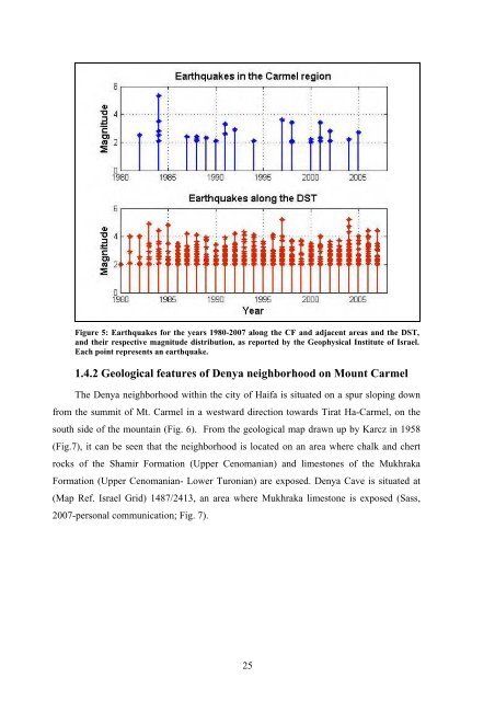
Figure 5: Earthquakes for <strong>the</strong> years 1980-2007 al<strong>on</strong>g <strong>the</strong> CF and adjacent areas and <strong>the</strong> DST,<br />
and <strong>the</strong>ir respective magnitude distributi<strong>on</strong>, as reported by <strong>the</strong> Geophysical Institute of Israel.<br />
Each point represents an earthquake.<br />
1.4.2 Geological features of Denya neighborhood <strong>on</strong> Mount Carmel<br />
The Denya neighborhood within <strong>the</strong> city of Haifa is situated <strong>on</strong> a spur sloping down<br />
from <strong>the</strong> summit of Mt. Carmel in a westward directi<strong>on</strong> towards Tirat Ha-Carmel, <strong>on</strong> <strong>the</strong><br />
south side of <strong>the</strong> mountain (Fig. 6). From <strong>the</strong> geological map drawn up by Karcz in 1958<br />
(Fig.7), it can be seen that <strong>the</strong> neighborhood is located <strong>on</strong> an area where chalk and chert<br />
rocks of <strong>the</strong> Shamir Formati<strong>on</strong> (Upper Cenomanian) and limest<strong>on</strong>es of <strong>the</strong> Mukhraka<br />
Formati<strong>on</strong> (Upper Cenomanian- Lower Tur<strong>on</strong>ian) are exposed. Denya Cave is situated at<br />
(Map Ref. Israel Grid) 1487/2413, an area where Mukhraka limest<strong>on</strong>e is exposed (Sass,<br />
2007-pers<strong>on</strong>al communicati<strong>on</strong>; Fig. 7).<br />
25