

Vegetation Classification and Mapping Project Report - the USGS
Vegetation Classification and Mapping Project Report - the USGS
Vegetation Classification and Mapping Project Report - the USGS

Create successful ePaper yourself
Turn your PDF publications into a flip-book with our unique Google optimized e-Paper software.
tsugae), large numbers of Park visitors, arson/accidental forest fires <strong>and</strong> exotic diseases (e.g.,<br />
chestnut blight, dogwood anthracnose, beech bark disease, butternut canker <strong>and</strong>, potentially,<br />
sudden oak death), Park managers needed analysis tools to assist <strong>the</strong>m in <strong>the</strong> preservation of<br />
valuable resources. Consequently, in 1999, <strong>the</strong> Center for Remote Sensing <strong>and</strong> <strong>Mapping</strong> Science<br />
at The University of Georgia entered into a Cooperative Agreement with <strong>the</strong> NPS to create a<br />
detailed digital database for GRSM that includes both overstory <strong>and</strong> understory vegetation <strong>and</strong><br />
an analysis of fuels that can cause forest fires in <strong>the</strong> Park.<br />
Methodology<br />
The main requirement for <strong>the</strong> project was to produce a vegetation database <strong>and</strong> associated<br />
maps in vector format that contained polygons for over 150 overstory <strong>and</strong> understory plant<br />
communities plotted to within approximately + 5 to + 10 m of <strong>the</strong>ir true ground locations.<br />
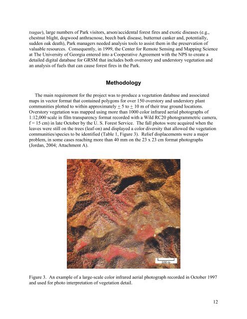
Overstory vegetation was mapped using more than 1000 color infrared aerial photographs of<br />
1:12,000 scale in film transparency format recorded with a Wild RC20 photogrammetric camera,<br />
f = 15 cm) in late October by <strong>the</strong> U. S. Forest Service. The fall photos were acquired when <strong>the</strong><br />
leaves were still on <strong>the</strong> trees (leaf-on) <strong>and</strong> displayed a color diversity that allowed <strong>the</strong> vegetation<br />
communities/species to be identified (Table 1, Figure 3). Relief displacements were a major<br />
problem, in some cases reaching more than 40 mm on <strong>the</strong> 23 x 23 cm format photographs<br />
(Jordan, 2004; Attachment A).<br />
Figure 3. An example of a large-scale color infrared aerial photograph recorded in October 1997<br />
<strong>and</strong> used for photo interpretation of vegetation detail.<br />
12


