- Page 1 and 2: Digital Vegetation Maps for the Gre
- Page 3 and 4: Table of Contents Page List of Figu
- Page 5 and 6: List of Figures (Continued) Figure
- Page 7 and 8: List of Attachments Attachment Atta
- Page 9 and 10: and animals in the world. It has be
- Page 11 and 12: logged or burned (Walker, 1991). Th
- Page 13 and 14: The understory vegetation was mappe
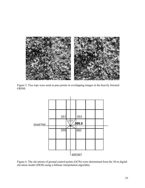
- Page 15: Photogrammetric Operations The main
- Page 19 and 20: The term “overstory vegetation”
- Page 21 and 22: provided in Attachment D, and furth
- Page 23 and 24: Figure 11. Hardcopy vegetation maps
- Page 25 and 26: to the terrain. Applications of the
- Page 27 and 28: Figure 13. Total area (hectares) of
- Page 29 and 30: Modeling Applications In addition t
- Page 31 and 32: Fuel Class 1 Short Grass Fuel Class
- Page 33 and 34: understory type and density, was th
- Page 35 and 36: Figure 17. A sample of the fire fue
- Page 37 and 38: The fuel class and percent canopy d
- Page 39 and 40: interfaced to auxiliary data system
- Page 41 and 42: References Albini, F. A., 1976. Est
- Page 43 and 44: Moore, H.L.A., 1988. A Roadside Gui
- Page 45 and 46: Control Extension and Orthorectific
- Page 47 and 48: Figure 2. The vegetation map produc
- Page 49 and 50: Table 2. Results of different image
- Page 51 and 52: Attachment B Attachment B Vegetatio
- Page 53 and 54: Attachment B Sub-Alpine Woodland 6.
- Page 55 and 56: Attachment B c. S. Appalachian Cove
- Page 57 and 58: Attachment B 10. White Oak-Red Mapl
- Page 59 and 60: Attachment B E. Southern Blue Ridge
- Page 61 and 62: Attachment B :G Graminoid spp. :Ht
- Page 63 and 64: Attachment C Photointerpreters from
- Page 65 and 66: Attachment C Our ecologically based
- Page 67 and 68:
Attachment C Mesic Oak-Hardwoods (l
- Page 69 and 70:
Attachment C Mixed (Virginia-Pitch-
- Page 71 and 72:
Attachment C prints for greatest di
- Page 73 and 74:
Attachment C the inhospitable smila
- Page 75 and 76:
Attachment C An NVCS association (a
- Page 77 and 78:
Attachment C only in protected cove
- Page 79 and 80:
Attachment C MOr/R-K (CEGL 7299) an
- Page 81 and 82:
Attachment C everything”: Fraser
- Page 83 and 84:
Attachment C 30. NHx:Bol, Southern
- Page 85 and 86:
Attachment C elevation, the hemlock
- Page 87 and 88:
Attachment C the surrounding tree c
- Page 89 and 90:
Attachment C Tom Govus should be al
- Page 91 and 92:
Attachment C Madden, M., 2003. Visu
- Page 93 and 94:
Attachment D species and it is beli
- Page 95 and 96:
Attachment D Hemlock understory wit
- Page 97 and 98:
Attachment D Spruce with heath bald
- Page 99 and 100:
Attachment E Attachment E Notes on
- Page 101 and 102:
Attachment E Springs, Wear Cove and
- Page 103 and 104:
Attachment E number of leaves are n
- Page 105 and 106:
Attachment F HxL 1403 4.9 0.0 141.1
- Page 107 and 108:
Attachment F R/T 26 2.4 0.4 6.8 62.
- Page 109 and 110:
Attachment G Attachment G Summary o
- Page 111 and 112:
Attachment G PIsu/Rm 1 11.0 11.0 11
- Page 113 and 114:
Attachment G T/PIs/Ri 53 6.6 0.7 31
- Page 115 and 116:
Attachment H Vegetation Modeling, A
- Page 117 and 118:
Attachment H Department of Agricult
- Page 119 and 120:
Attachment H isolated from the over
- Page 121:
Attachment H 8