

Vegetation Classification and Mapping Project Report - the USGS
Vegetation Classification and Mapping Project Report - the USGS
Vegetation Classification and Mapping Project Report - the USGS

Create successful ePaper yourself
Turn your PDF publications into a flip-book with our unique Google optimized e-Paper software.
In order to accommodate <strong>the</strong> complex vegetation patterns found in GRSM <strong>and</strong> generally<br />
maintain a minimum mapping unit of 0.5 ha, a three-tiered scheme was developed for attributing<br />
vegetation polygons, similar to that developed for an earlier project in <strong>the</strong> Everglades of south<br />
Florida (Madden et al. 1999). The three-tiered scheme allowed photointerpreters to annotate<br />
each polygon in <strong>the</strong> database with a primary or dominant vegetation class accounting for more<br />
than 50 percent of <strong>the</strong> vegetation in <strong>the</strong> polygon. Where appropriate, secondary <strong>and</strong> tertiary<br />
vegetation classes are added to describe mixed-plant communities within <strong>the</strong> polygon. Secondary<br />
<strong>and</strong> tertiary classes were especially useful for describing ecotones, <strong>and</strong> for polygons with a<br />
patchwork of communities below <strong>the</strong> minimum mapping unit size. See Attachment C for fur<strong>the</strong>r<br />
explanation of <strong>the</strong> three-tiered polygon attribution procedure.<br />
A separate classification system containing over 196 unique association-level classes was<br />
developed by CRMS photointerpreters in consultation with NPS resource managers to map <strong>the</strong><br />
understory vegetation (Table 3).<br />
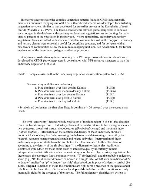
Table 3. Sample classes within <strong>the</strong> understory vegetation classification system for GRSM.<br />
_______________________________________________________________________<br />
Pine overstory with Kalmia understory<br />
a. Pine dominant over high density Kalmia (PI/Kh)<br />
b. Pine dominant over medium density Kalmia (PI/Km)<br />
c. Pine dominant over low density Kalmia (PI/Kl)<br />
d. Pine dominant over possible Kalmia (PI/Kp)<br />
e. Pine dominant over implied Kalmia (PI/Ki)<br />
* Symbols: (/) designates <strong>the</strong> first class listed is dominate (> 50 percent) over <strong>the</strong> second class<br />
listed.<br />
The term “understory” denotes woody vegetation of medium height (3 to 5 m) that does not<br />
reach <strong>the</strong> forest canopy level. Understory classes of particular interest to fire managers included<br />
two evergreen, broad-leaf shrubs: rhododendron (Rhododendron spp.) <strong>and</strong> mountain laurel<br />
(Kalmia latifolia). Information on <strong>the</strong> location <strong>and</strong> density of <strong>the</strong>se understory shrubs is<br />
important for modeling fire fuels, assessing fire behavior <strong>and</strong> determining accessibility for<br />
research, resource management <strong>and</strong> search <strong>and</strong> rescue activities. Interpretation of <strong>the</strong>se<br />
understory vegetation strata from <strong>the</strong> air photos, <strong>the</strong>refore, included fur<strong>the</strong>r classification<br />
according to <strong>the</strong> density of <strong>the</strong> shrub as light (l), medium (m) or heavy (h). Additional<br />
subclasses were added for <strong>the</strong>se shrub areas of interest to qualify uncertainty in <strong>the</strong>ir<br />
interpretation <strong>and</strong> identification when <strong>the</strong> understory was obscured by overstory vegetation. In<br />
<strong>the</strong>se cases, <strong>the</strong> evergreen forest community (e.g., “T” for hemlock) <strong>and</strong> <strong>the</strong> probable understory<br />
shrub (e.g., “R” for rhododendron) are combined in a single label of T/R with an indicator of “i”<br />
to denote “implied” or “p” to denote “possible” rhododendron, in place of a density symbol (i.e.,<br />
T/Ri). Implied is defined to mean <strong>the</strong> conditions are right for <strong>the</strong> presence of <strong>the</strong> species <strong>and</strong> it<br />
is believed to be found <strong>the</strong>re. On <strong>the</strong> o<strong>the</strong>r h<strong>and</strong>, possible is defined as <strong>the</strong> conditions are only<br />
marginally right for <strong>the</strong> presence of <strong>the</strong> species. The full understory classification system is<br />
20


