

Vegetation Classification and Mapping Project Report - the USGS
Vegetation Classification and Mapping Project Report - the USGS
Vegetation Classification and Mapping Project Report - the USGS

You also want an ePaper? Increase the reach of your titles
YUMPU automatically turns print PDFs into web optimized ePapers that Google loves.
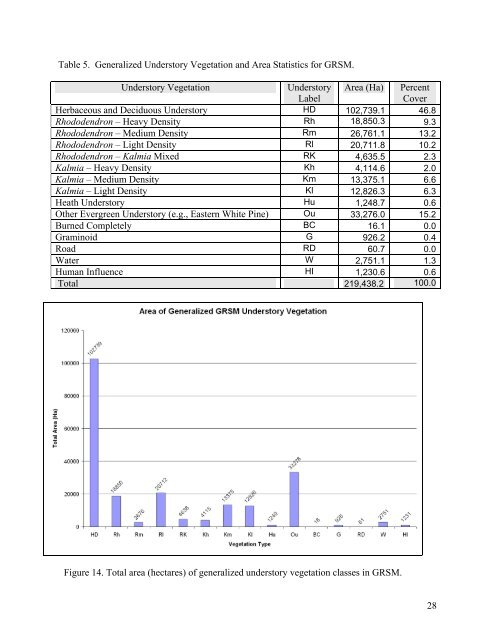
Table 5. Generalized Understory <strong>Vegetation</strong> <strong>and</strong> Area Statistics for GRSM.<br />
Understory <strong>Vegetation</strong><br />
Understory<br />
Label<br />
Area (Ha) Percent<br />
Cover<br />
Herbaceous <strong>and</strong> Deciduous Understory HD 102,739.1 46.8<br />
Rhododendron – Heavy Density Rh 18,850.3 9.3<br />
Rhododendron – Medium Density Rm 26,761.1 13.2<br />
Rhododendron – Light Density Rl 20,711.8 10.2<br />
Rhododendron – Kalmia Mixed RK 4,635.5 2.3<br />
Kalmia – Heavy Density Kh 4,114.6 2.0<br />
Kalmia – Medium Density Km 13,375.1 6.6<br />
Kalmia – Light Density Kl 12,826.3 6.3<br />
Heath Understory Hu 1,248.7 0.6<br />
O<strong>the</strong>r Evergreen Understory (e.g., Eastern White Pine) Ou 33,276.0 15.2<br />
Burned Completely BC 16.1 0.0<br />
Graminoid G 926.2 0.4<br />
Road RD 60.7 0.0<br />
Water W 2,751.1 1.3<br />
Human Influence HI 1,230.6 0.6<br />
Total 219,438.2 100.0<br />
Figure 14. Total area (hectares) of generalized understory vegetation classes in GRSM.<br />
28


