

Vegetation Classification and Mapping Project Report - the USGS
Vegetation Classification and Mapping Project Report - the USGS
Vegetation Classification and Mapping Project Report - the USGS

You also want an ePaper? Increase the reach of your titles
YUMPU automatically turns print PDFs into web optimized ePapers that Google loves.
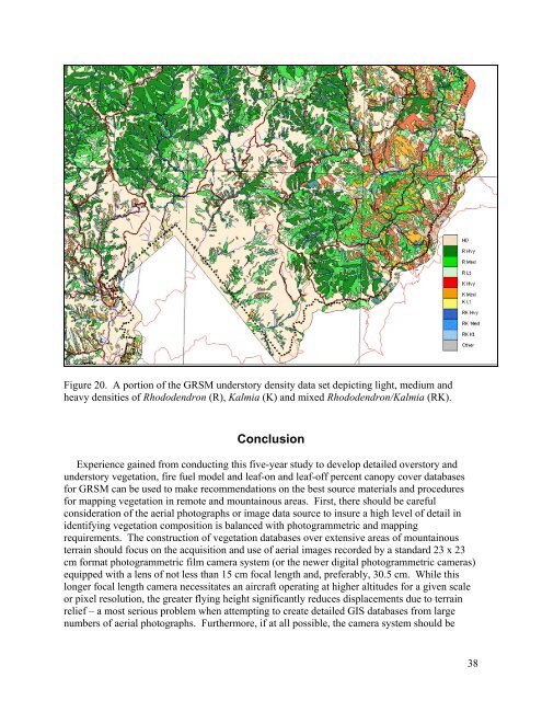
Figure 20. A portion of <strong>the</strong> GRSM understory density data set depicting light, medium <strong>and</strong><br />
heavy densities of Rhododendron (R), Kalmia (K) <strong>and</strong> mixed Rhododendron/Kalmia (RK).<br />
Conclusion<br />
Experience gained from conducting this five-year study to develop detailed overstory <strong>and</strong><br />
understory vegetation, fire fuel model <strong>and</strong> leaf-on <strong>and</strong> leaf-off percent canopy cover databases<br />
for GRSM can be used to make recommendations on <strong>the</strong> best source materials <strong>and</strong> procedures<br />
for mapping vegetation in remote <strong>and</strong> mountainous areas. First, <strong>the</strong>re should be careful<br />
consideration of <strong>the</strong> aerial photographs or image data source to insure a high level of detail in<br />
identifying vegetation composition is balanced with photogrammetric <strong>and</strong> mapping<br />
requirements. The construction of vegetation databases over extensive areas of mountainous<br />
terrain should focus on <strong>the</strong> acquisition <strong>and</strong> use of aerial images recorded by a st<strong>and</strong>ard 23 x 23<br />
cm format photogrammetric film camera system (or <strong>the</strong> newer digital photogrammetric cameras)<br />
equipped with a lens of not less than 15 cm focal length <strong>and</strong>, preferably, 30.5 cm. While this<br />
longer focal length camera necessitates an aircraft operating at higher altitudes for a given scale<br />
or pixel resolution, <strong>the</strong> greater flying height significantly reduces displacements due to terrain<br />
relief – a most serious problem when attempting to create detailed GIS databases from large<br />
numbers of aerial photographs. Fur<strong>the</strong>rmore, if at all possible, <strong>the</strong> camera system should be<br />
38


