

Vegetation Classification and Mapping Project Report - the USGS
Vegetation Classification and Mapping Project Report - the USGS
Vegetation Classification and Mapping Project Report - the USGS

Create successful ePaper yourself
Turn your PDF publications into a flip-book with our unique Google optimized e-Paper software.
Overstory <strong>and</strong> Understory <strong>Vegetation</strong> Database <strong>and</strong> Map Products<br />
Upon differential rectification of <strong>the</strong> scanned raster overlay files, <strong>the</strong>se files are converted to<br />
vector format with <strong>the</strong> software package R2V by Able Software Company (Cambridge,<br />
Massachusetts) <strong>and</strong> saved in ArcInfo line format. Vector files from approximately 45<br />
photographs must be edited, edgematched <strong>and</strong> incorporated into a single ArcInfo coverage to<br />
produce one vegetation map corresponding to <strong>the</strong> area covered by a single <strong>USGS</strong> topographic<br />
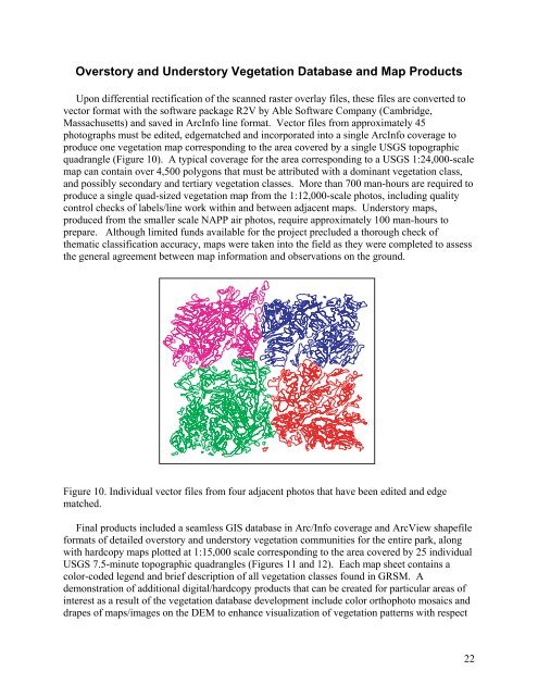
quadrangle (Figure 10). A typical coverage for <strong>the</strong> area corresponding to a <strong>USGS</strong> 1:24,000-scale<br />
map can contain over 4,500 polygons that must be attributed with a dominant vegetation class,<br />
<strong>and</strong> possibly secondary <strong>and</strong> tertiary vegetation classes. More than 700 man-hours are required to<br />
produce a single quad-sized vegetation map from <strong>the</strong> 1:12,000-scale photos, including quality<br />
control checks of labels/line work within <strong>and</strong> between adjacent maps. Understory maps,<br />
produced from <strong>the</strong> smaller scale NAPP air photos, require approximately 100 man-hours to<br />
prepare. Although limited funds available for <strong>the</strong> project precluded a thorough check of<br />
<strong>the</strong>matic classification accuracy, maps were taken into <strong>the</strong> field as <strong>the</strong>y were completed to assess<br />
<strong>the</strong> general agreement between map information <strong>and</strong> observations on <strong>the</strong> ground.<br />
Figure 10. Individual vector files from four adjacent photos that have been edited <strong>and</strong> edge<br />
matched.<br />
Final products included a seamless GIS database in Arc/Info coverage <strong>and</strong> ArcView shapefile<br />
formats of detailed overstory <strong>and</strong> understory vegetation communities for <strong>the</strong> entire park, along<br />
with hardcopy maps plotted at 1:15,000 scale corresponding to <strong>the</strong> area covered by 25 individual<br />
<strong>USGS</strong> 7.5-minute topographic quadrangles (Figures 11 <strong>and</strong> 12). Each map sheet contains a<br />
color-coded legend <strong>and</strong> brief description of all vegetation classes found in GRSM. A<br />
demonstration of additional digital/hardcopy products that can be created for particular areas of<br />
interest as a result of <strong>the</strong> vegetation database development include color orthophoto mosaics <strong>and</strong><br />
drapes of maps/images on <strong>the</strong> DEM to enhance visualization of vegetation patterns with respect<br />
22


