

Vegetation Classification and Mapping Project Report - the USGS
Vegetation Classification and Mapping Project Report - the USGS
Vegetation Classification and Mapping Project Report - the USGS

Create successful ePaper yourself
Turn your PDF publications into a flip-book with our unique Google optimized e-Paper software.
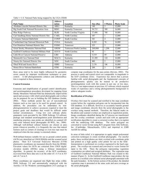
Table 1: U.S. National Parks being mapped by <strong>the</strong> UGA-CRMS<br />
Abbreviation<br />
Park Name<br />
Location Size (Ha) # Photos Photo Scale<br />
Abraham Lincoln National Historic Site ABLI Kentucky 140 3 12,000<br />
Big South Fork National Recreation Area BISO Kentucky/Tennessee 50,733 309 16,000<br />
Blue Ridge Parkway BLRI North Carolina/Virginia 37,408 768 16,000<br />
Carl S<strong>and</strong>burg Home National Historic Site CARL North Carolina 107 1 12,000<br />
Cowpens National Battlefield COWP South Carolina 341 4 12,000<br />
Cumberl<strong>and</strong> Gap National Historical Park CUGA Kentucky 8,285 76 16,000<br />
Fort Donelson National Historic Site FODO Tennessee 223 3 12,000<br />
Great Smoky Mountains National Park GRSM Tennessee/North Carolina 209,000 1,200 12,000<br />
Guilford Courthouse National Military Park GUCO North Carolina 93 1 12,000<br />
Little River Canyon National Preserve LIRI Alabama 5,519 89 12,000<br />
Mammoth Cave National Park MACA Kentucky 21,389 124 16,000<br />
Ninety-Six National Historic Site NISI South Carolina 400 2 12,000<br />
Obed Wild <strong>and</strong> Scenic River<br />
OBRI Tennessee 2,156 106 16,000<br />
Stones River National Battlefield<br />
STRI Kentucky 288 3 12,000<br />
<strong>the</strong>se areas tend to be more highly influenced by geometric<br />
errors caused by improper rectification techniques or poor<br />
control. A full photogrammetric solutio n <strong>and</strong> orthorectification<br />
is required in <strong>the</strong>se instances.<br />
Control Extension<br />
Extension <strong>and</strong> simplification of ground control identification<br />
<strong>and</strong> aerotriangulation procedures developed for mapping Great<br />
Smoky Mountains National Park has dramatically improved <strong>the</strong><br />
speed <strong>and</strong> accuracy with which aerial photographs <strong>and</strong> overlays<br />
can be prepared for use in building <strong>the</strong> GIS database (Jordan,<br />
2002). These methods permit <strong>the</strong> use of non-traditional<br />
features such as tree tops to be used for ground control. In<br />
addition, <strong>the</strong> procedures can be undertaken by nonphotogrammetrists<br />
to achieve accuracies required to meet <strong>the</strong><br />
project goals <strong>and</strong> deadlines that would be difficult under<br />
normal circumstances. Using low cost softcopy photogrammetry<br />
tools provided by <strong>the</strong> DMS Softcopy 5.0 software<br />
package <strong>and</strong> st<strong>and</strong>ard aerotriangulation point distribution <strong>and</strong><br />
numbering practises, pass points are identified on scanned (42<br />
µm) color infrared aerial photographs (R-WEL, Inc., 2004).<br />
Although well-defined cultural features are chosen as pass<br />
points whenever possible, it is frequently <strong>the</strong> case that natural<br />
features such as corners of clearings or even tree tops must be<br />
employed when <strong>the</strong> tree canopy is extremely dense.<br />
Well-defined features suitable for use as ground control points<br />
(GCPs) are identified on <strong>USGS</strong> DOQQs <strong>and</strong> <strong>the</strong> scanned aerial<br />
photos. Their X,Y Universal Transverse Mercator (UTM)<br />
planimetric coordinates are measured directly from <strong>the</strong> DOQQ.<br />
Elevation values for GCPs are extracted from <strong>USGS</strong> digital<br />
elevation models (DEMs) using a bilinear interpolation<br />
algorithm. In general, <strong>the</strong> accuracy of <strong>the</strong> GCP coordinates<br />
recovered from <strong>the</strong>se data sets is on <strong>the</strong> order of ± 3-5 m in XY<br />
<strong>and</strong> ±4-7 m in Z.<br />
Photo coordinates are organized into flight line strips within<br />
DMS Softcopy 5.0 <strong>and</strong> automatically employed with <strong>the</strong><br />
AeroSys 5.0 for Windows aerotriangulation (AT) package to<br />
compute map coordinates for <strong>the</strong> pass points (Stevens, 2002). The<br />
process is quick <strong>and</strong> typical errors are comparable in magnitude to<br />
<strong>the</strong> GCP coordinate errors. Experience has shown that a person<br />
familiar with aerial photographs <strong>and</strong> <strong>the</strong> fundamental concepts of<br />
photogrammetry quickly can be trained to do productive<br />
aerotriangulation work with this system in just one or two days.<br />
This is a vast improvement on previous AT software which required<br />
weeks of experience <strong>and</strong> a strong photogrammetric background to<br />
achieve adequate results.<br />
Rectification of Overlays<br />
Overlays first must be scanned <strong>and</strong> rectified to <strong>the</strong> map coordinate<br />
system before <strong>the</strong> vegetation polygons can be incorporated into <strong>the</strong><br />
GIS database. It is difficult, however, to accurately transfer ground<br />
<strong>and</strong> image coordinates directly from <strong>the</strong> aerial photographs to <strong>the</strong><br />
overlays using manual methods. Therefore, <strong>the</strong> fiducial marks on<br />
<strong>the</strong> photos <strong>and</strong> scanned overlays are employed as registration points.<br />
Image coordinates identified during <strong>the</strong> AT process are transformed<br />
into <strong>the</strong> overlay coordinate system <strong>and</strong> used with an appropriate<br />
rectification algorithm to create a corrected overlay that is in register<br />
with <strong>the</strong> underlying GIS database. The raster polygons are<br />
converted to vector for mat using R2V program from Able Software,<br />
Inc. (Cambridge, Massachusetts, USA) <strong>and</strong> imported to ESRI<br />
ArcGIS for editing.<br />
In areas of little relief, it is appropriate to apply simple polynomial<br />
correction techniques to create rectified photographs. For sma ller<br />
parks, <strong>the</strong>se rectified photos are tiled, overlaid with coordinate grids<br />
<strong>and</strong> printed on a high quality color printer for use in <strong>the</strong> field.<br />
Interpretation is performed on overlays registered to <strong>the</strong> hard copy<br />
prints. The overlays are scanned <strong>and</strong> converted to vector format for<br />
input to <strong>the</strong> GIS. There <strong>the</strong> polygons representing vegetation<br />
communities are edited <strong>and</strong> assigned attributes. The vegetation map<br />
of Guilford Courthouse National Military Park was created in this<br />
manner (Figure 2). In <strong>the</strong> Guilford Courthouse map product, <strong>the</strong> top<br />
portion in a rectified color infrared aerial photograph annotated with<br />
<strong>the</strong> park boundary. In <strong>the</strong> bottom section of <strong>the</strong> product, <strong>the</strong> detailed<br />
vegetation map is presented at <strong>the</strong> same scale <strong>and</strong> area coverage as<br />
<strong>the</strong> aerial photograph.


