

Vegetation Classification and Mapping Project Report - the USGS
Vegetation Classification and Mapping Project Report - the USGS
Vegetation Classification and Mapping Project Report - the USGS

You also want an ePaper? Increase the reach of your titles
YUMPU automatically turns print PDFs into web optimized ePapers that Google loves.
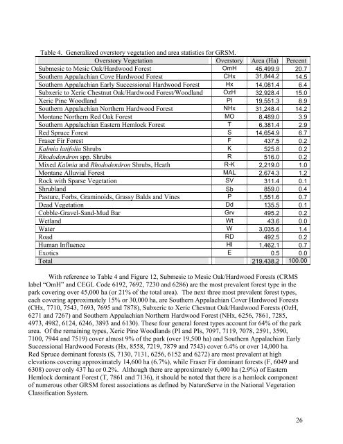
Table 4. Generalized overstory vegetation <strong>and</strong> area statistics for GRSM.<br />
Overstory <strong>Vegetation</strong> Overstory Area (Ha) Percent<br />
Submesic to Mesic Oak/Hardwood Forest OmH 45,499.9 20.7<br />
Sou<strong>the</strong>rn Appalachian Cove Hardwood Forest CHx 31,844.2 14.5<br />
Sou<strong>the</strong>rn Appalachian Early Successional Hardwood Forest Hx 14,081.4 6.4<br />
Subxeric to Xeric Chestnut Oak/Hardwood Forest/Woodl<strong>and</strong> OzH 32,928.4 15.0<br />
Xeric Pine Woodl<strong>and</strong> PI 19,551.3 8.9<br />
Sou<strong>the</strong>rn Appalachian Nor<strong>the</strong>rn Hardwood Forest NHx 31,248.4 14.2<br />
Montane Nor<strong>the</strong>rn Red Oak Forest MO 8,489.0 3.9<br />
Sou<strong>the</strong>rn Appalachian Eastern Hemlock Forest T 6,381.4 2.9<br />
Red Spruce Forest S 14,654.9 6.7<br />
Fraser Fir Forest F 437.5 0.2<br />
Kalmia latifolia Shrubs K 525.8 0.2<br />
Rhododendron spp. Shrubs R 516.0 0.2<br />
Mixed Kalmia <strong>and</strong> Rhododendron Shrubs, Heath R-K 2,219.0 1.0<br />
Montane Alluvial Forest MAL 2,674.3 1.2<br />
Rock with Sparse <strong>Vegetation</strong> SV 311.4 0.1<br />
Shrubl<strong>and</strong> Sb 859.0 0.4<br />
Pasture, Forbs, Graminoids, Grassy Balds <strong>and</strong> Vines P 1,551.6 0.7<br />
Dead <strong>Vegetation</strong> Dd 135.5 0.1<br />
Cobble-Gravel-S<strong>and</strong>-Mud Bar Grv 495.2 0.2<br />
Wetl<strong>and</strong> Wt 43.6 0.0<br />
Water W 3,035.6 1.4<br />
Road RD 492.5 0.2<br />
Human Influence HI 1,462.1 0.7<br />
Exotics E 0.5 0.0<br />
Total 219,438.2 100.00<br />
With reference to Table 4 <strong>and</strong> Figure 12, Submesic to Mesic Oak/Hardwood Forests (CRMS<br />
label “OmH” <strong>and</strong> CEGL Code 6192, 7692, 7230 <strong>and</strong> 6286) are <strong>the</strong> most prevalent forest type in <strong>the</strong><br />
park covering over 45,000 ha (or 21% of <strong>the</strong> total area). The next three most prevalent forest types,<br />
each covering approximately 15% or 30,000 ha, are Sou<strong>the</strong>rn Appalachian Cover Hardwood Forests<br />
(CHx, 7710, 7543, 7693, 7695 <strong>and</strong> 7878), Subxeric to Xeric Chestnut Oak/Hardwood Forests (OzH,<br />
6271 <strong>and</strong> 7267) <strong>and</strong> Sou<strong>the</strong>rn Appalachian Nor<strong>the</strong>rn Hardwood Forest (NHx, 6256, 7861, 7285,<br />
4973, 4982, 6124, 6246, 3893 <strong>and</strong> 6130). These four general forest types account for 64% of <strong>the</strong> park<br />
area. Of <strong>the</strong> remaining types, Xeric Pine Woodl<strong>and</strong>s (PI <strong>and</strong> PIs, 7097, 7119, 7078, 2591, 3590,<br />
7100, 7944 <strong>and</strong> 7519) cover almost 9% of <strong>the</strong> park (over 19,500 ha) <strong>and</strong> Sou<strong>the</strong>rn Appalachian Early<br />
Successional Hardwood Forests (Hx, 8558, 7219, 7879 <strong>and</strong> 7543) cover 6.4% or over 14,000 ha.<br />
Red Spruce dominant forests (S, 7130, 7131, 6256, 6152 <strong>and</strong> 6272) are most prevalent at high<br />
elevations covering approximately 14,600 ha (6.7%), while Fraser Fir dominant forests (F, 6049 <strong>and</strong><br />
6308) cover only 437 ha or 0.2%. Although <strong>the</strong>re are approximately 6,400 ha (2.9%) of Eastern<br />
Hemlock dominant Forest (T, 7861 <strong>and</strong> 7136), it should be noted that <strong>the</strong>re is a hemlock component<br />
of numerous o<strong>the</strong>r GRSM forest associations as defined by NatureServe in <strong>the</strong> National <strong>Vegetation</strong><br />
<strong>Classification</strong> System.<br />
26


