

Fremantle Port Inner Harbour and Channel ... - Fremantle Ports
Fremantle Port Inner Harbour and Channel ... - Fremantle Ports
Fremantle Port Inner Harbour and Channel ... - Fremantle Ports
- No tags were found...

Create successful ePaper yourself
Turn your PDF publications into a flip-book with our unique Google optimized e-Paper software.
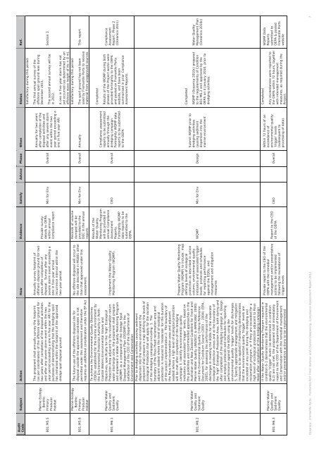
AuditCodeSubject Action How Evidence Satisfy Advice Phase When Status Ref.Satisfactory during this period.801:M5.5801:M5.6801:M6.1801:M6.2801:M6.3Marine Ecology– BenthicPrimaryProducerHabitatMarine Ecology– BenthicPrimaryProducerHabitatMarine WaterQuality <strong>and</strong>SedimentQualityMarine WaterQuality <strong>and</strong>SedimentQualityMarine WaterQuality <strong>and</strong>SedimentQualityThe proponent shall annually survey the footprint(as per coordinates) of the offshore spoil ground fortwo years after completion of the disposal activities<strong>and</strong> after any severe storm event within the twoyear period exceeding a one in five year ARI for thepurposes of demonstrating that the dredging spoilhas remained within the footprint of the approveddredge spoil disposal groundThe future use of the offshore disposal site fordisposal outside the approved coordinates is notpermitted under this assessment <strong>and</strong> thereforerequires an additional consideration under the EP ActTo achieve the Environmental Quality Objectives(EQOs) established for the marine environment bythe Environmental Protection Authority in PerthCoastal Waters Environmental Values <strong>and</strong>Objectives, specifically for the ‘high’ EcologicalProtection Area adjacent to the reclamation returnwater discharge zone, the proponent shall prepare<strong>and</strong> implement a Water Quality Monitoring Program(WQMP) as a component of the Dredge SpoilDisposal Management Plan (DSDMP) to thesatisfaction of the CEO of the Department ofEnvironment <strong>and</strong> ConservationPrior to dredging activities causing sedimentdispersion into the marine environment theproponent shall prepare a map defining the levels ofEcological Protection that will apply for the durationof the dredging campaign including: 1. Theboundary of the Rous Head reclamation area <strong>and</strong>adjacent seabed where the level of ecologicalprotection is reduced to ‘moderate’ for the durationof the project implementation 2. The boundary ofthe Rous Head reclamation area <strong>and</strong> adjacentseabed where a high level of ecological protectionwill be met after completion of the dredgingcampaign 3. Identify environmental qualityindicators <strong>and</strong> associated ‘trigger’ levels, based onthe guidelines <strong>and</strong> recommended approaches in theAustralian <strong>and</strong> New Zeal<strong>and</strong> Guideline for Fresh <strong>and</strong>Marine Water Quality (ANZECC & ARMCANZ, 2000)<strong>and</strong> the Environmental Quality Criteria ReferenceDocument for Cockburn Sound (2003 – 2004) (EPA,2005), for assessing the performance of thedischarges in meeting the EQOs for the moderateecological protection areas <strong>and</strong> at the boundary ofthe ‘high’ Ecological Protection Area, both during <strong>and</strong>after completion of the dredging campaign 4. Design<strong>and</strong> employ protocols <strong>and</strong> schedules for reportingperformance against the EQOs using theenvironmental quality ‘trigger’ levels for discharges5. Specify appropriate management <strong>and</strong> mitigationmeasures to be applied if monitoring demonstratesthat the environmental quality ‘trigger’ levels areexceeded at any point during the dredging <strong>and</strong>reclamation program, or if they are exceeded for ahigh level of ecological protection adjacent to RousHead after completion of the dredging campaignIf the Water Quality Monitoring Program required incondition 6-1 demonstrates that the environmentalquality ‘trigger’ levels (as determined in condition6.2) are not met, the proponent shall immediatelyreport to the CEO of the Department of Environment<strong>and</strong> Conservation with the remedial management<strong>and</strong>/or preventative actions to be implementedAnnually survey footprint ofoffshore disposal ground for twoyears after completion ofdisposal. Survey after anysevere storm event exceeding aone in five-year annualrecurrence interval within thetwo-year period.No offshore disposal will occur tothe site described in MS801 otherthan that approved under thisassessment.Implement the Water QualityMonitoring Program (WQMP).Prepare Water Quality MonitoringProgram (WQMP) to include: mapdefining levels of ecologicalprotection as described in actioncolumn; environmental qualityindicators <strong>and</strong> associated triggerlevels; protocols <strong>and</strong> schedulesfor reporting performanceagainst the EQOs; <strong>and</strong>management <strong>and</strong> mitigationmeasuresProvide report to the CEO of theOEPA with the remedialmanagement <strong>and</strong>/or preventativeactions to be implementedfollowing the exceedance oftrigger levelsProvide surveydetails to OEPAwithin annualcompliance reportRecords of volumedumped will beprovided to theDEC in the annualreportsResults of theWater QualityMonitoring Programwill be provided inannual ComplianceAssessmentReports.Fortnightly WQMPdata reports to besubmitted to theOEPA.Min for Env OverallMin for Env Overall AnnuallyCEO OverallWQMP Min for Env DesignReport to the CEOof the OEPACEO OverallAnnually for two yearsafter completion of thedisposal activities <strong>and</strong>after any severe stormevent within the twoyear period exceeding aone in five year ARICompliance assessmentreports to be submittedannually through thedredging campaign.Fortnightly WQMP datareports to be submittedto the OEPASubmit WQMP prior todredging activitiescausing sedimentdispersion into themarine environmentWithin 72 hours of anexceedance ofenvironmental quality‘trigger’ levels(subsequent toprocessing of data).The first annual survey of theoffshore spoil ground was duringDecember 2011.The second annual survey will bein 2012.A one in five-year storm has notyet occurred (as determined by anoffshore wave height of Hs > 8 m).Satisfactory during this periodThe spoil ground has not beenused by <strong>Fremantle</strong> <strong>Port</strong>s to receivematerial from unapproved sources.CompletedResults of the WQMP during bothphases of the Project works wereprovided fortnightly to the OEPA<strong>and</strong> posted on <strong>Fremantle</strong> <strong>Port</strong>swebsite, <strong>and</strong> have beensummarised in prior ComplianceAssessment Reports.CompletedWQMP (Oceanica 2010c) preparedto the requirements of Condition801:M6.2 <strong>and</strong> approved by theOEPA on 4 January 2010, prior todredging activities.CompletedAny exceedances were reported tothe OEPA within 72 hours, togetherwith intended managementmeasures, as required during theProject.Section 3This reportComplianceAssessmentReport: Phase 2(Oceanica 2011)Water QualityManagement Plan(Oceanica 2010c)WQMP DataReportssubmitted toOEPA & posted<strong>Fremantle</strong> <strong>Port</strong>swebsiteOceanica: <strong>Fremantle</strong> <strong>Port</strong>s: <strong>Fremantle</strong> <strong>Port</strong> <strong>Inner</strong> <strong>Harbour</strong> <strong>and</strong> <strong>Channel</strong> Deepening, Compliance Assessment Report 2012 7


