Download full document - MiDA Ghana
Download full document - MiDA Ghana
Download full document - MiDA Ghana

Create successful ePaper yourself
Turn your PDF publications into a flip-book with our unique Google optimized e-Paper software.
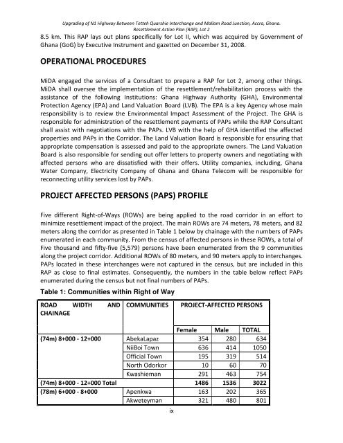
Upgrading of N1 Highway Between Tetteh Quarshie Interchange and Mallam Road Junction, Accra, <strong>Ghana</strong>.Resettlement Action Plan (RAP), Lot 28.5 km. This RAP lays out plans specifically for Lot II, which was acquired by Government of<strong>Ghana</strong> (GoG) by Executive Instrument and gazetted on December 31, 2008.OPERATIONAL PROCEDURES<strong>MiDA</strong> engaged the services of a Consultant to prepare a RAP for Lot 2, among other things.<strong>MiDA</strong> shall oversee the implementation of the resettlement/rehabilitation process with theassistance of the following Institutions: <strong>Ghana</strong> Highway Authority (GHA), EnvironmentalProtection Agency (EPA) and Land Valuation Board (LVB). The EPA is a key Agency whose mainresponsibility is to review the Environmental Impact Assessment of the Project. The GHA isresponsible for administration of the resettlement payments of PAPs while the RAP Consultantshall assist with negotiations with the PAPs. LVB with the help of GHA identified the affectedproperties and PAPs in the Corridor. The Land Valuation Board is responsible for ensuring thatappropriate compensation is assessed and paid to the appropriate owners. The Land ValuationBoard is also responsible for sending out offer letters to property owners and negotiating withaffected persons who are dissatisfied with their offers. Utility companies, including, <strong>Ghana</strong>Water Company, Electricity Company of <strong>Ghana</strong> and <strong>Ghana</strong> Telecom will be responsible forreconnecting utility services lost by PAPs.PROJECT AFFECTED PERSONS (PAPS) PROFILEFive different Right-of-Ways (ROWs) are being applied to the road corridor in an effort tominimize resettlement impact of the project. The main ROWs are 74 meters, 78 meters, and 82meters along the corridor as presented in Table 1 below by chainage with the numbers of PAPsenumerated in each community. From the census of affected persons in these ROWs, a total ofFive thousand and fifty-five (5,579) persons have been enumerated from the 9 communitiesalong the project corridor. Additional ROWs of 80 meters, and 90 meters apply to interchanges.PAPs located in these interchanges were not captured in the census, but are included in thisRAP as close to final estimates. Consequently, the numbers in the table below reflect PAPsenumerated during the census but not final numbers of PAPs.Table 1: Communities within Right of WayROAD WIDTH ANDCHAINAGECOMMUNITIESPROJECT-AFFECTED PERSONSFemale Male TOTAL(74m) 8+000 - 12+000 AbekaLapaz 354 280 634NiiBoi Town 636 414 1050Official Town 195 319 514North Odorkor 10 60 70Kwashieman 291 463 754(74m) 8+000 - 12+000 Total 1486 1536 3022(78m) 6+000 - 8+000 Apenkwa 163 202 365Akweteyman 321 480 801ix