World Air Ops | NAT | Doc 007 MNPS Guidance
World Air Ops | NAT | Doc 007 MNPS Guidance
World Air Ops | NAT | Doc 007 MNPS Guidance

Create successful ePaper yourself
Turn your PDF publications into a flip-book with our unique Google optimized e-Paper software.
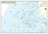
<strong>Guidance</strong> concerning <strong>Air</strong> Navigation in and above the <strong>NAT</strong> <strong>MNPS</strong>A CHAPTER 16Special non-compliance routings16.2.5 <strong>Air</strong>craft not equipped with two functioning Long Range Navigation Systems may only flythrough <strong>NAT</strong> <strong>MNPS</strong> <strong>Air</strong>space via special designated routes. This is discussed in Chapter 1 at paragraph 1.4.Details of these special routes are contained in Chapter 11 at paragraph 11.2.2.16.2.6 <strong>Air</strong>craft not approved for <strong>MNPS</strong>/RVSM operations may climb and descend through <strong>NAT</strong><strong>MNPS</strong>/RVSM <strong>Air</strong>space and in very limited, specified circumstances an <strong>MNPS</strong> Approved aircraft that is notApproved for RVSM operations may be granted permission to flight plan and operate through <strong>MNPS</strong><strong>Air</strong>space at RVSM levels. (See Chapter 1 at 1.5 and 1.6).16.2.7 Routings that may be flight planned and operated through <strong>NAT</strong> <strong>MNPS</strong> <strong>Air</strong>space by aircraftwithout functioning HF Communications equipment may be limited by the State of Registry of the operatoror by the ATC Provider. This is discussed above in more detail at paragraph 4.2.12.16.3 Route PlanningLateral separation minima & resulting route definition conventions16.3.1 In the North Atlantic <strong>MNPS</strong> <strong>Air</strong>space the lateral separation standard is 60 NM. Since60 NM is equivalent to one degree of latitude along any meridian and given that the vast majority of flightsthrough this airspace are generally eastbound or westbound, this standard is deemed to be met by tracksseparated by one degree of latitude at common meridians.16.3.2 Radar/ADS-B data is only available in very limited areas of the North Atlantic Region.Therefore, ATC must depend upon aircraft supplied position reports for flight progress information. In orderto provide separation assurance, ATC requires updates on the progress of flights at no more than hourlyintervals. It has been determined that this criteria is met over a wide range of ground speeds if eastbound orwestbound <strong>NAT</strong> flights report on passing each ten degrees of longitude. The criteria is also met bynorthbound or southbound flights reporting on passing each five degrees of latitude. In consequence, allflights which will generally route in an eastbound or westbound direction should normally be flight plannedby specifying significant points at whole degrees of latitude at each crossed ten degrees of longitude (20°W,30°W, 40°W etc.); and all generally northbound or southbound flights should normally be flight planned sothat specified parallels of latitude spaced at five degree intervals (65°N, 60°N, 55°N etc.) are crossed atwhole degrees of longitude. (N.B. North of 70°N the east/west distance between successive ten degreelongitudes is less than 200 NM, or approximately 25 mins flight time. Consequently, eastbound/westbound<strong>NAT</strong> routings north of 70°N need only be defined by significant points at each twenty degrees of longitude(i.e at 0°W, 20°W, 40°W, 60°W)).OTS – Rationale, Structure, CDM & Track Message16.3.3 As a result of passenger demand, time zone differences and airport noise restrictions, muchof the North Atlantic (<strong>NAT</strong>) air traffic contributes to two major alternating flows: a westbound flowdeparting Europe in the morning, and an eastbound flow departing North America in the evening. The effectof these flows is to concentrate most of the traffic unidirectionally, with peak westbound traffic crossing the30W longitude between 1130 UTC and 1900 UTC and peak eastbound traffic crossing the 30W longitudebetween 0100 UTC and 0800 UTC.16.3.4 The <strong>NAT</strong> <strong>MNPS</strong> <strong>Air</strong>space is consequently congested at peak hours and in order to providethe best service to the bulk of the traffic, a system of organised tracks is constructed to accommodate asmany flights as possible within the major flows, on or close to their minimum time tracks and altitudeprofiles. Due to the energetic nature of the <strong>NAT</strong> weather patterns, including the presence of jet streams,<strong>NAT</strong> <strong>Doc</strong> <strong>007</strong> 92 Edition 2010