Public Open Space Guidelines 2.17 Mb - Devonport City Council
Public Open Space Guidelines 2.17 Mb - Devonport City Council
Public Open Space Guidelines 2.17 Mb - Devonport City Council

Create successful ePaper yourself
Turn your PDF publications into a flip-book with our unique Google optimized e-Paper software.
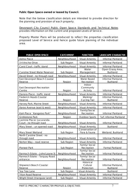
<strong>Public</strong> <strong>Open</strong> <strong>Space</strong> owned or leased by <strong>Council</strong>.Note that the below classification details are intended to provide direction forthe planning and provision of each property.<strong>Devonport</strong> <strong>City</strong> <strong>Council</strong> <strong>Public</strong> <strong>Open</strong> <strong>Space</strong> Standards and Technical Notesprovides information on the current and proposed Levels of Service.Property Master Plans will be produced to reflect the properties classificationproposed Level of Service and hence guide future planning of the individualarea.PUBLIC OPEN SPACE CATCHMENT FUNCTION LANSCAPE CHARACTERAdina Place Neighbourhood Visual Amenity Informal Parkland3-4 Anchor Drive Sub Region Visual Amenity Informal ParklandCarol Court - traffic island Neighbourhood Visual Amenity Informal ParklandCaroline Street Water Reservoir Sub RegionWaterManagement<strong>Open</strong> Grassy Area,BushlandDavid Street - no through road Neighbourhood Visual Amenity Informal ParklandEast <strong>Devonport</strong> Beach CoastalReserveRegionWater BasedRecreationInformal Parkland,BushlandEast <strong>Devonport</strong> RecreationCentreRegionIndoorCommunityActivityInformal ParklandElanora Place - traffic island Neighbourhood Visual Amenity Informal ParklandFrederick Heads CoastalReserveRegionWalking/Cycling TrailInformal Parkland,BushlandHarvey Park, Marine Street Neighbourhood Visual Amenity Informal ParklandIllaroo Avenue (east & west) Neighbourhood Visual Amenity Informal ParklandKiah Place ‘ Kangaloo Park” NeighbourhoodFamily/SocialRecreation Informal ParklandGirdlestone Park Region Outdoor Sports Turf, Informal ParklandJasmine Place/ JacarandaCourt - no through road Neighbourhood Visual Amenity Informal ParklandMary Street – un opened road Neighbourhood Visual Amenity BushlandMary Street WetlandSub RegionConservation ofFlora & Fauna Wetland, BushlandNorth Caroline Street - nothrough road Neighbourhood Visual Amenity Informal ParklandNorton Way – road reserve Sub Region Visual Amenity Informal ParklandPioneer ParkSub RegionFamily/ SocialRecreation Formal ParklandRannoch Estate – John/Loane St NeighbourhoodFamily/ SocialRecreation Informal ParklandRannoch Estate – Torquay RoadentranceNeighbourhoodFamily/ SocialRecreation Informal ParklandShipwreck Beach CoastalReserveRegionHistoricalCulturalProtectionInformal Parkland,BushlandTea Tree Lane Sub Region Visual Amenity BushlandTriton Road Reserve Neighbourhood Visual Amenity Informal ParklandWright Street (triangular land) Sub Region Visual Amenity Informal ParklandPART D: PRECINCT CHARACTER PROFILES & OBJECTIVES 7