<strong>North</strong> Walsham Conservation Area Character Appraisal and Management Planpoint for the weekly market, and as a meeting point for the local community. Market Streetis a short wide road which appears very much as a continuation of the Market Place, with asimilar architectural character. The ground slopes up to the east, so that Market Street risesto meet Market Place which is in turn inclined so that the east end is higher than the west.These subtle slopes add visual interest to the townscape.The church is screened from Market Street by a narrow row of houses, although its partlyruined tower is highly visible in the town. The church porch can also be glimpsed down apassageway opposite the Market Cross. The churchyard is a shallow rectangular grassmound, almost featureless apart from a few street lights, as all the gravestones have beenremoved to the south side. It serves as a small informal park although lacks facilities,particularly seating.On the north east side of the churchyard is St Nicholas Court, a mid 20th century shoppingarcade centred around a paved courtyard. The architecture is undistinguished and a poorinterruption to the historic core. Little of the Court is visible from the central streets; it isconnected to them by narrow lanes leading from the Market Place and Market Street.The roads leading off from the Market Place and Market Street contain a higher proportionof late Victorian buildings than the centre. As the roads pass outside the Conservation Area,the townscape is generally of lower visual quality.To the south of the Market Place, older buildings have been cleared away to create a carpark and space for a large store, Roys of Wroxham. There are historic buildings nearby,such as at the entrance to the Market Place, but their positive character is diluted by themodern encroachments. There is a similar situation at the rear of the Mitre Tavern Yard,where early buildings mix with the back of the modern shopping arcade and a scruffy areaused as a car park.The Paston Sixth Form College occupies a considerable part of the Conservation Area tothe south of the Market Place. While it contains a good deal of open space and some finebuildings, these have relatively little impact on the streetscape. Apart from a tree bedeckedentrance on Grammar School Road, and an inter-war block fronting King’s Arms Street,much is hidden from public view.Leaving aside the St Nicholas Court shopping arcade and car parking areas to the south,the historic character of the Market Place and the smaller side roads within the ConservationArea is largely intact. There are no other large scale developments from the Victorian orlater periods. Late 19th and 20th century additions to the town have followed a roughlyconcentric rather than linear plan, radiating away from the historic core. Larger facilities,which might have been expected within the Conservation Area, such as the Post Office,Town Hall and Library, are all located on the periphery.3.3 Landscape setting<strong>North</strong> Walsham is surrounded by relatively flat arable land, with a mixture of rich loam andsandy soils. The landscape has a generally homogenous character, comprising fields withhedgerows and isolated trees, and the occasional house or farm building. On the north eastside a gentle slope leads down to the river Ant. To the east is the former <strong>North</strong> Walshamand Dilham canal, although only part of the watercourse now survives. There are also smallareas of woodland to the east. No commons survive; three commons belonging to the townare known to have been enclosed c.1830 and were subsequently built upon.8<strong>North</strong> <strong>Norfolk</strong> <strong>District</strong> <strong>Council</strong>
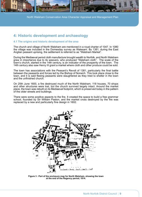
<strong>North</strong> Walsham Conservation Area Character Appraisal and Management Plan4: Historic development and archaeology4.1 The origins and historic development of the areaThe church and village of <strong>North</strong> Walsham are mentioned in a royal charter of 1047. In 1080the village was included in the Domesday survey as Walesam. By 1381, during the EastAnglian peasant uprising, the settlement is referred to as “Walsham Market”.During the Mediaeval period cloth manufacture brought wealth to <strong>Norfolk</strong>, and <strong>North</strong> Walshamgrew in importance due to its weavers, who produced “Walsham cloth”. The scale of thetown’s church, started in the 14th century, is an indicator of the prosperity of the town. The14th century also saw Henry III grant a market where cloth and other produce could be sold.The town has associations with the Peasant’s Revolt of 1381, particularly the final battlebetween the peasants and forces led by the Bishop of Norwich. This took place close to thetown, and it is said fleeing peasants were slaughtered as they tried to shelter in the townand the unfinished church.On 25th June 1600, a fire destroyed much of the <strong>North</strong> Walsham. 118 houses, 70 shopsand other structures were lost, but the church survived largely intact. Around the marketplace, the town was rebuilt on its Mediaeval footprint, which is preserved today in the patternof the older streets and buildings.There were some positive aspects to the fire. It created the space to build a free grammarschool, founded by Sir William Paston, and the market cross destroyed by the fire wasreplaced by a new and particularly fine design in 1602.Figure 3 : Part of the enclosure map for <strong>North</strong> Walsham, showing the townat the end of the Regency period, 1814.<strong>North</strong> <strong>Norfolk</strong> <strong>District</strong> <strong>Council</strong>9