

NW CA cover:Layout 1 - North Norfolk District Council
NW CA cover:Layout 1 - North Norfolk District Council
NW CA cover:Layout 1 - North Norfolk District Council
- No tags were found...

You also want an ePaper? Increase the reach of your titles
YUMPU automatically turns print PDFs into web optimized ePapers that Google loves.
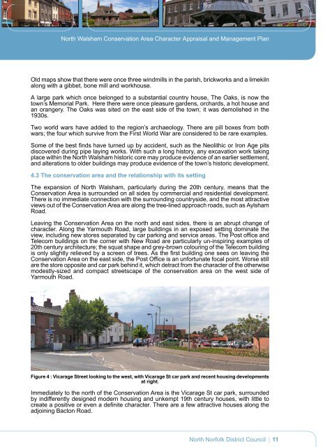
<strong>North</strong> Walsham Conservation Area Character Appraisal and Management PlanOld maps show that there were once three windmills in the parish, brickworks and a limekilnalong with a gibbet, bone mill and workhouse.A large park which once belonged to a substantial country house, The Oaks, is now thetown’s Memorial Park. Here there were once pleasure gardens, orchards, a hot house andan orangery. The Oaks was sited on the east side of the town; it was demolished in the1930s.Two world wars have added to the region’s archaeology. There are pill boxes from bothwars; the four which survive from the First World War are considered to be rare examples.Some of the best finds have turned up by accident, such as the Neolithic or Iron Age pitsdis<strong>cover</strong>ed during pipe laying works. With such a long history, any excavation work takingplace within the <strong>North</strong> Walsham historic core may produce evidence of an earlier settlement,and alterations to older buildings may produce evidence of the town’s historic development.4.3 The conservation area and the relationship with its settingThe expansion of <strong>North</strong> Walsham, particularly during the 20th century, means that theConservation Area is surrounded on all sides by commercial and residential development.There is no immediate connection with the surrounding countryside, and the most attractiveviews out of the Conservation Area are along the tree-lined approach roads, such as AylshamRoad.Leaving the Conservation Area on the north and east sides, there is an abrupt change ofcharacter. Along the Yarmouth Road, large buildings in an exposed setting dominate theview, including new stores separated by car parking and service areas. The Post office andTelecom buildings on the corner with New Road are particularly un-inspiring examples of20th century architecture; the squat shape and grey-brown colouring of the Telecom buildingis only slightly relieved by a screen of trees. As the first building one sees on leaving theConservation Area on the east side, the Post Office is an unfortunate focal point. Worse stillare the store opposite and car park behind it, which detract from the character of the otherwisemodestly-sized and compact streetscape of the conservation area on the west side ofYarmouth Road.Figure 4 : Vicarage Street looking to the west, with Vicarage St car park and recent housing developmentsat right.Immediately to the north of the Conservation Area is the Vicarage St car park, surroundedby indifferently designed modern housing and unkempt 19th century houses, with little tocreate a positive or even a definite character. There are a few attractive houses along theadjoining Bacton Road.<strong>North</strong> <strong>Norfolk</strong> <strong>District</strong> <strong>Council</strong>11


