

NW CA cover:Layout 1 - North Norfolk District Council
NW CA cover:Layout 1 - North Norfolk District Council
NW CA cover:Layout 1 - North Norfolk District Council
- No tags were found...

Create successful ePaper yourself
Turn your PDF publications into a flip-book with our unique Google optimized e-Paper software.
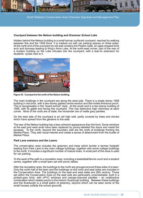
<strong>North</strong> Walsham Conservation Area Character Appraisal and Management PlanCourtyard between the Nelson building and Grammar School LokeHidden behind the Nelson building is a small tarmac surfaced courtyard, reached by walkingbetween this and the 1928 block. It is marked out with car parking spaces on three sides.At the north end of the courtyard an old wall contains the Paston Gate, an ogee-shaped brickarch and doorway leading to King’s Arms Loke. At the north-east corner, part of the rear ofa modern building on the Loke intrudes into the courtyard, with a lean-to extension forstudents’ cycles next to it.Figure 35 : Courtyard to the north of the Nelson building.The main buildings in the courtyard are along the west side. There is a single storey 1908building in red brick, with a two-storey gabled centre section and flat-roofed entrance porch.This is recognisably in the “board school” style. At the south end is a two-storey building of1906, with its gable end facing the courtyard. This has distinctive high chimneys at eachcorner. Most of the roofs are of slate; the remainder are of matte grey pantiles.On the east side of the courtyard is an old high wall, partly <strong>cover</strong>ed by trees and shrubswhich have spread from the gardens to the east.The rear of the Nelson building has a less coherent appearance than the front. Some windowsat the east and west ends have been replaced by poorly-detailed fire doors and metal fireescapes. To the north, beyond the boundary wall are the roofs of buildings fronting theMarket Place. They add visual interest and create a sense of detachment from the bustle ofMarket Place.Park Lane entrance and the LawnsThe conservation area includes the greenery and trees which border a tarmac footpathleading from Park Lane to the main college buildings, together with some college buildingsto the north. It includes a significant number of mature trees. A small part of this area is usedfor car parking.To the west of the path is a recreation area, including a basketball/tennis court and a studentcentre, together with a small lawn set with picnic tables.After the recreation area, the buildings to the north are grouped around three sides of a lawn.Only the north half of the lawn and the buildings on the north and east sides are included inthe Conservation Area. The buildings on the east and west sides are 20th century. Thoseset within the Conservation Area on the east side are particularly unremarkable, built in apinkish-grey brick, with uPVC windows and orange-coloured pantiles – an unattractivecombination which relates poorly to the historic Scarburgh building. Between these buildingsand the Scarburgh is a small patch of greenery, beyond which can be seen some of thesmall houses outside the school grounds.<strong>North</strong> <strong>Norfolk</strong> <strong>District</strong> <strong>Council</strong>39


