Climate risks and adaptation in Asian coastal megacities: A synthesis
Climate risks and adaptation in Asian coastal megacities: A synthesis
Climate risks and adaptation in Asian coastal megacities: A synthesis
- No tags were found...

You also want an ePaper? Increase the reach of your titles
YUMPU automatically turns print PDFs into web optimized ePapers that Google loves.
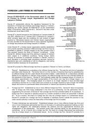
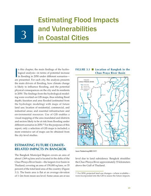
3Estimat<strong>in</strong>g Flood Impacts<strong>and</strong> Vulnerabilities<strong>in</strong> Coastal CitiesIn this chapter, the ma<strong>in</strong> f<strong>in</strong>d<strong>in</strong>gs of the hydrologicalanalysis—<strong>in</strong> terms of potential <strong>in</strong>crease<strong>in</strong> flood<strong>in</strong>g <strong>in</strong> 2050 under different scenarios—are presented. For each city, the analysis presentsthe ma<strong>in</strong> drivers of flood<strong>in</strong>g, how climate changeis likely to <strong>in</strong>fluence flood<strong>in</strong>g, <strong>and</strong> the potentialphysical consequences on the city <strong>and</strong> its residents<strong>in</strong> 2050. The f<strong>in</strong>d<strong>in</strong>gs from the hydrological model<strong>in</strong>gwere overlaid on GIS maps, thus relat<strong>in</strong>g flooddepth/duration <strong>and</strong> area flooded (estimated fromthe hydrologic model<strong>in</strong>g) with maps of futurel<strong>and</strong> use; location of residential, commercial, <strong>and</strong><strong>in</strong>dustrial areas; <strong>and</strong> essential <strong>in</strong>frastructure <strong>and</strong>environmental resources. Use of GIS enables avisual mapp<strong>in</strong>g of the area <strong>in</strong>undated <strong>and</strong> districts<strong>and</strong> sectors likely to be at risk from flood<strong>in</strong>g underdifferent scenarios <strong>in</strong> 2050. 29 For the purposes of thisreport, only a selection of GIS maps is <strong>in</strong>cluded; amore extensive set of maps can be obta<strong>in</strong>ed fromthe city-level studies.Estimat<strong>in</strong>g Future <strong>Climate</strong>relatedImpacts <strong>in</strong> BangkokThe Bangkok Municipal Region covers an area ofabout 1,569 sq kms <strong>and</strong> is located <strong>in</strong> the delta of theChao Phraya River bas<strong>in</strong>—the largest river bas<strong>in</strong> <strong>in</strong>Thail<strong>and</strong>, cover<strong>in</strong>g an area of 159,000 sq kms, or 35percent of the total l<strong>and</strong> area of the country (Figure3.1). The bas<strong>in</strong> area is flat at an average elevationof 1–2m from mean sea level. Some areas are at seaFigure 3.1 ■ Location of Bangkok <strong>in</strong> theChao Praya River Bas<strong>in</strong>THAILANDCHAO PHRAYA RIVER18°M YA N M A RAndamanSea0 100KILOMETERSPROJECT RIVERSELECTED CITIESNATIONAL CAPITALINTERNATIONALBOUNDARYThis map was produced by the Map Design Unit of The World Bank.The boundaries, colors, denom<strong>in</strong>ations <strong>and</strong> any other <strong>in</strong>formationshown on this map do not imply, on the part of The World BankGroup, any judgment on the legal status of any territory, or anyendorsement or acceptance of such boundaries.MYANMARNAYPYIDAW15°NArea ofMapAndamanSea15°N15°NLAOP.D.R.VIENTIANETHAILANDBANGKOKGulf ofThail<strong>and</strong>PHNOMPENH100°E MALAYSIA 105°EHANOIVIETNAMCAMBODIASource: Thail<strong>and</strong> map IBRD 37477.14°Chiang MaiTakPathum ThaniNonthaburiBangkokSamut PrakanRatchaburi SamutSakhonGulf ofThail<strong>and</strong>100°level due to l<strong>and</strong> subsidence. Bangkok straddlesthe Chao Phraya River approximately 33 kilometersabove the Gulf of Thail<strong>and</strong>.29For 2050, projected l<strong>and</strong> use changes—where available—were <strong>in</strong>corporated <strong>in</strong>to the GIS to assess the future impacts.YomKamphaengPhetP<strong>in</strong>g100°Nakhon SawanUthai ThaniSupham BuriTha Ch<strong>in</strong>PhraeUttaraditPhichitNanCha<strong>in</strong>atChao PhrayaNanT H A I L A N DS<strong>in</strong>g BuriThahanbok Lop BuriAng ThongL A OP. D . R .Phra Nakhon Si AyutthayaIBRD 37477102°102°20°18°16°14°JANUARY 201023